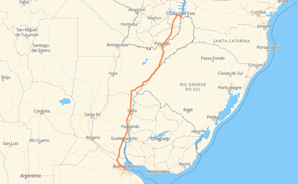
Distance between Buenos Aires and Puerto Iguazú
The distance from Buenos Aires to Puerto Iguazú is 807 miles by road including 40 miles on motorways. Road takes approximately 13 hours and 37 minutes and goes through Vicente López, Zárate, Alvear, Posadas, Encarnacion, Minga Guazú and Ciudad del Este.
| Shortest distance by air | 663 mi ✈️ |
| Car route length | 806.5 mi 🚗 |
| Driving time | 13 h 37 min |
| Fuel amount | 100.8 gal |
| Fuel cost | 103.8 USD |
| Point | Distance | Time | Fuel | |
| Buenos Aires | 0 mi | 00 min | 0.0 gal | |
|
8 mi, 12 min
|
||||
| Vicente López | 8 mi | 12 min | 0.9 gal | |
|
RN9 50 mi, 42 min
|
||||
| Zárate | 59 mi | 55 min | 6.2 gal | |
|
RN12 RN14 411 mi, 6 h 03 min
|
||||
| Alvear | 470 mi | 6 h 58 min | 58.5 gal | |
|
RN14 146 mi, 2 h 48 min
|
||||
| Posadas | 616 mi | 9 h 46 min | 76.8 gal | |
|
RN105 6 mi, 07 min
|
||||
| Encarnacion | 621 mi | 9 h 54 min | 77.4 gal | |
|
PY01 PY06 158 mi, 3 h 05 min
|
||||
| Minga Guazú | 779 mi | 12 h 59 min | 96.0 gal | |
|
PY02 14 mi, 18 min
|
||||
| Ciudad del Este | 793 mi | 13 h 18 min | 98.8 gal | |
|
PY02 BR-277 5 mi, 08 min
|
||||
| Foz do Iguaçu | 798 mi | 13 h 26 min | 99.6 gal | |
|
9 mi, 10 min
|
||||
| Puerto Iguazú | 808 mi | 13 h 37 min | 100.6 gal | |
Hotels of Puerto Iguazú
Frequently Asked Questions
How much does it cost to drive from Buenos Aires to Puerto Iguazú?
Fuel cost: 103.8 USD
This fuel cost is calculated as: (Route length 806.5 mi) / (Fuel consumption 8.00 mpg) * (Fuel price 1.03 USD / gal)
You can adjust fuel consumption and fuel price here.
How long is a car ride from Buenos Aires to Puerto Iguazú?
Driving time: 13 h 37 min
This time is calculated for driving at the maximum permitted speed, taking into account traffic rules restrictions.
- 23 mi with a maximum speed 81 mph = 17 min
- 173 mi with a maximum speed 75 mph = 2 h 19 min
- 144 mi with a maximum speed 68 mph = 2 h 6 min
- 245 mi with a maximum speed 62 mph = 3 h 56 min
- 182 mi with a maximum speed 50 mph = 3 h 39 min
- 25 mi with a maximum speed 37 mph = 40 min
- 1 mi with a maximum speed 31 mph = 2 min
- 13 mi with a maximum speed 25 mph = 30 min
- 1 mi with a maximum speed 19 mph = 1 min
- 1 mi with a maximum speed 12 mph = 3 min
The calculated driving time does not take into account intermediate stops and traffic jams.
How far is Buenos Aires to Puerto Iguazú by land?
The distance between Buenos Aires and Puerto Iguazú is 806.5 mi by road including 39.8 mi on motorways.
Precise satellite coordinates of highways were used for this calculation. The start and finish points are the centers of Buenos Aires and Puerto Iguazú respectively.
How far is Buenos Aires to Puerto Iguazú by plane?
The shortest distance (air line, as the crow flies) between Buenos Aires and Puerto Iguazú is 663 mi.
This distance is calculated using the Haversine formula as a great-circle distance between two points on the surface of a sphere. The start and finish points are the centers of Buenos Aires and Puerto Iguazú respectively. Actual distance between airports may be different.
How many hours is Buenos Aires from Puerto Iguazú by plane?
Boeing 737 airliner needs 1 h 20 min to cover the distance of 663 mi at a cruising speed of 497 mph.
Small plane "Cessna 172" needs 4 h 51 min to flight this distance at average speed of 136 mph.
This time is approximate and do not take into account takeoff and landing times, airport location and other real world factors.
How long is a helicopter ride from Buenos Aires to Puerto Iguazú?
Fast helicopter "Eurocopter AS350" or "Hughes OH-6 Cayuse" need 4 h 26 min to cover the distance of 663 mi at a cruising speed of 149 mph.
Popular "Robinson R44" needs 5 h 4 min to flight this distance at average speed of 130 mph.
This time is approximate and do not take into account takeoff and landing times, aerodrome location and other real world factors.
What city is halfway between Buenos Aires and Puerto Iguazú?
The halfway point between Buenos Aires and Puerto Iguazú is Alvear. It is located about 67 mi from the exact midpoint by road.
The distance from Alvear to Buenos Aires is 470 mi and driving will take about 6 h 58 min. The road between Alvear and Puerto Iguazú has length 336 mi and will take approximately 6 h 39 min.
The other cities located close to halfway point:
Where is Buenos Aires in relation to Puerto Iguazú?
Buenos Aires is located 663 mi south-west of Puerto Iguazú.
Buenos Aires has geographic coordinates: latitude -34.60756, longitude -58.43708.
Puerto Iguazú has geographic coordinates: latitude -25.61268, longitude -54.57434.
Which highway goes from Buenos Aires to Puerto Iguazú?
The route from Buenos Aires to Puerto Iguazú follows RN14, PY06.
Other minor sections pass along the road:
- RN12: 48 mi
- RN9: 40 mi
- RN105: 30 mi
- PY02: 17 mi
- RP6: 5 mi
- PY01: 4 mi
- PY18: 1 mi