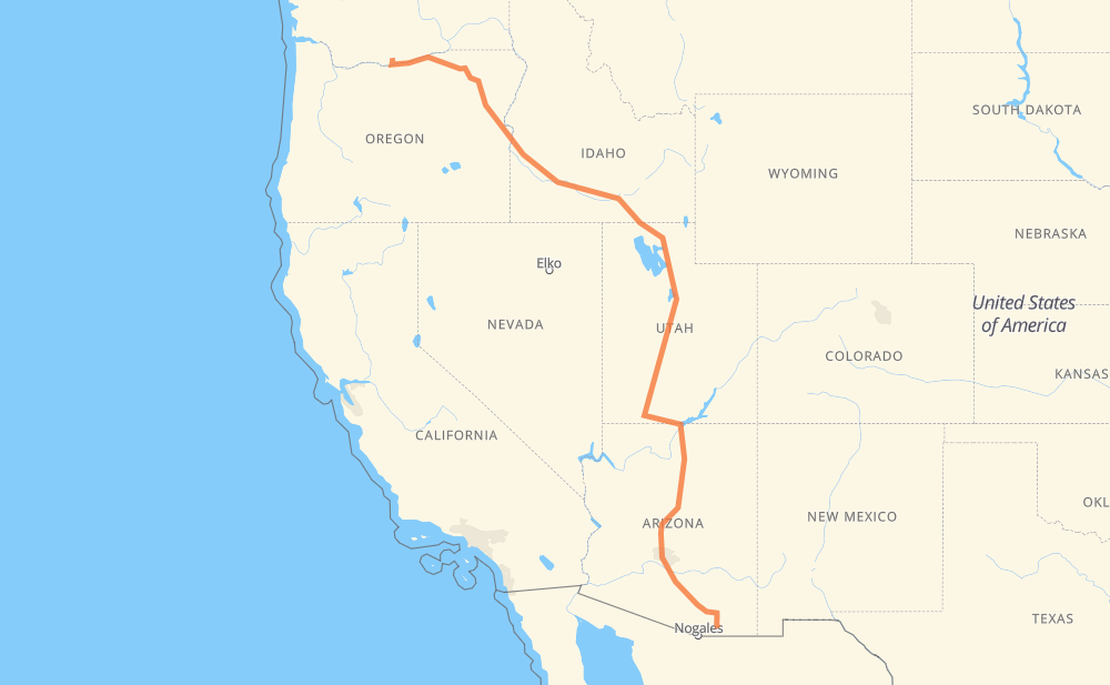
Distance between Goldendale WA and Sierra Vista AZ
The distance from Goldendale to Sierra Vista is 2,449 kilometers by road including 1,898 kilometers on motorways. Road takes approximately 24 hours and 33 minutes and goes through Ogden, Salt Lake City, Provo, Flagstaff, Phoenix, Chandler and Tucson.
How much does it cost to drive from Goldendale to Sierra Vista?
Fuel cost:
197.9 USD
This fuel cost is calculated as: (Route length 2,449 km / 100 km) * (Fuel consumption 8.00 L/100 km) * (Fuel price 1.04 USD / L)
You can adjust fuel consumption and fuel price here.
How long is a car ride from Goldendale to Sierra Vista?
Driving time:
24 h 33 min
This time is calculated for driving at the maximum permitted speed, taking into account traffic rules restrictions.
1,345 km with a maximum speed 109 km/h = 12 h 20 min
160 km with a maximum speed 105 km/h = 1 h 31 min
204 km with a maximum speed 100 km/h = 2 h 2 min
7 km with a maximum speed 97 km/h = 4 min
456 km with a maximum speed 90 km/h = 5 h 3 min
56 km with a maximum speed 89 km/h = 37 min
8 km with a maximum speed 80 km/h = 6 min
177 km with a maximum speed 80 km/h = 2 h 13 min
19 km with a maximum speed 72 km/h = 15 min
4 km with a maximum speed 64 km/h = 4 min
9 km with a maximum speed 56 km/h = 9 min
2 km with a maximum speed 50 km/h = 2 min
1 km with a maximum speed 40 km/h = 1 min
The calculated driving time does not take into account intermediate stops and traffic jams.
How far is Goldendale to Sierra Vista by land?
The distance between Goldendale and Sierra Vista is 2,449 km by road including 1,898 km on motorways.
Precise satellite coordinates of highways were used for this calculation. The start and finish points are the centers of Goldendale and Sierra Vista respectively.
How far is Goldendale to Sierra Vista by plane?
The shortest distance (air line, as the crow flies) between Goldendale and Sierra Vista is 1,827 km.
This distance is calculated using the Haversine formula as a great-circle distance between two points on the surface of a sphere. The start and finish points are the centers of Goldendale and Sierra Vista respectively. Actual distance between airports may be different.
How many hours is Goldendale from Sierra Vista by plane?
Boeing 737 airliner needs 2 h 17 min to cover the distance of 1,827 km at a cruising speed of 800 km/h.
Small plane "Cessna 172" needs 8 h 18 min to flight this distance at average speed of 220 km/h.
This time is approximate and do not take into account takeoff and landing times, airport location and other real world factors.
How long is a helicopter ride from Goldendale to Sierra Vista?
Fast helicopter "Eurocopter AS350" or "Hughes OH-6 Cayuse" need 7 h 36 min to cover the distance of 1,827 km at a cruising speed of 240 km/h.
Popular "Robinson R44" needs 8 h 42 min to flight this distance at average speed of 210 km/h.
This time is approximate and do not take into account takeoff and landing times, aerodrome location and other real world factors.
What city is halfway between Goldendale and Sierra Vista?
The halfway point between Goldendale and Sierra Vista is Nephi. It is located about 7 km from the exact midpoint by road.
The distance from Nephi to Goldendale is 1,217 km and driving will take about 11 h 52 min. The road between Nephi and Sierra Vista has length 1,232 km and will take approximately 12 h 41 min.
The other cities located close to halfway point:
Payson is in 1,180 km from Goldendale and 1,269 km from Sierra Vista
Spanish Fork is in 1,170 km from Goldendale and 1,279 km from Sierra Vista
Provo is in 1,159 km from Goldendale and 1,291 km from Sierra Vista
Where is Goldendale in relation to Sierra Vista?
Goldendale is located 1,827 km north-west of Sierra Vista.
Goldendale has geographic coordinates: latitude 45.82068, longitude -120.82173.
Sierra Vista has geographic coordinates: latitude 31.55454, longitude -110.30369.
Which highway goes from Goldendale to Sierra Vista?
The route from Goldendale to Sierra Vista follows I 84, US 30, US 89, I 15, I 10, I 17, US 26.