Distance between São Pedro da Afurada and Rio Mau
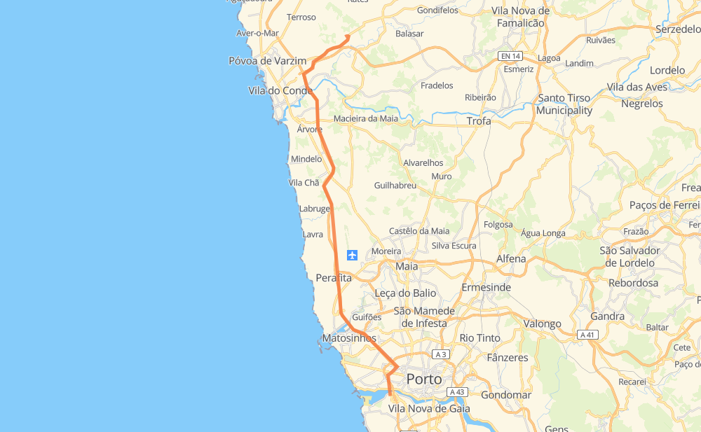
The distance from São Pedro da Afurada to Rio Mau is 22 miles by road including 19 miles on motorways. Road takes approximately 24 minutes and goes through Lordelo do Ouro, Senhora da Hora, Matosinhos, Leça da Palmeira, Aveleda, Retorta and Árvore.
| Shortest distance by air | 18 mi ✈️ |
| Car route length | 22.4 mi 🚗 |
| Driving time | 24 min |
| Fuel amount | 0.6 gal |
| Fuel cost | 3 USD |
| Point | Distance | Time | Fuel | |
| São Pedro da Afurada | 0 mi | 00 min | 0.0 gal | |
|
A 1 2 mi, 02 min
|
||||
| Lordelo do Ouro | 2 mi | 02 min | 0.0 gal | |
|
IC 23 A 28 2 mi, 03 min
|
||||
| Senhora da Hora | 4 mi | 05 min | 0.1 gal | |
|
A 28 1 mi, 01 min
|
||||
| Matosinhos | 6 mi | 06 min | 0.1 gal | |
|
A 28 1 mi, 01 min
|
||||
| Leça da Palmeira | 6 mi | 07 min | 0.2 gal | |
|
A 28 4 mi, 03 min
|
||||
| Aveleda | 11 mi | 11 min | 0.2 gal | |
|
A 28 7 mi, 05 min
|
||||
| Retorta | 17 mi | 17 min | 0.4 gal | |
|
A 28 2 mi, 02 min
|
||||
| Touguinha | 19 mi | 19 min | 0.5 gal | |
|
A 28 1 mi, 01 min
|
||||
| Touguinhó | 21 mi | 21 min | 0.6 gal | |
|
EN 206 2 mi, 02 min
|
||||
| Rio Mau | 22 mi | 23 min | 0.6 gal | |
Frequently Asked Questions
How much does it cost to drive from São Pedro da Afurada to Rio Mau?
Fuel cost: 3 USD
This fuel cost is calculated as: (Route length 22.4 mi) / (Fuel consumption 35.31 mpg) * (Fuel price 4.72 USD / gal)
You can adjust fuel consumption and fuel price here.
How long is a car ride from São Pedro da Afurada to Rio Mau?
Driving time: 24 min
This time is calculated for driving at the maximum permitted speed, taking into account traffic rules restrictions.
- 9 mi with a maximum speed 68 mph = 7 min
- 6 mi with a maximum speed 62 mph = 5 min
- 6 mi with a maximum speed 50 mph = 6 min
- 1 mi with a maximum speed 43 mph = 1 min
- 1 mi with a maximum speed 25 mph = 1 min
The calculated driving time does not take into account intermediate stops and traffic jams.
How far is São Pedro da Afurada to Rio Mau by land?
The distance between São Pedro da Afurada and Rio Mau is 22.4 mi by road including 19.3 mi on motorways.
Precise satellite coordinates of highways were used for this calculation. The start and finish points are the centers of São Pedro da Afurada and Rio Mau respectively.
What city is halfway between São Pedro da Afurada and Rio Mau?
The halfway point between São Pedro da Afurada and Rio Mau is Aveleda. It is located about 1 mi from the exact midpoint by road.
The distance from Aveleda to São Pedro da Afurada is 11 mi and driving will take about 11 min. The road between Aveleda and Rio Mau has length 12 mi and will take approximately 12 min.
The other cities located close to halfway point:
Where is São Pedro da Afurada in relation to Rio Mau?
São Pedro da Afurada is located 18 mi south of Rio Mau.
São Pedro da Afurada has geographic coordinates: latitude 41.14298, longitude -8.64282.
Rio Mau has geographic coordinates: latitude 41.39947, longitude -8.68547.
Which highway goes from São Pedro da Afurada to Rio Mau?
The route from São Pedro da Afurada to Rio Mau follows A 28.
Other minor sections pass along the road:
- EN 206: 2 mi