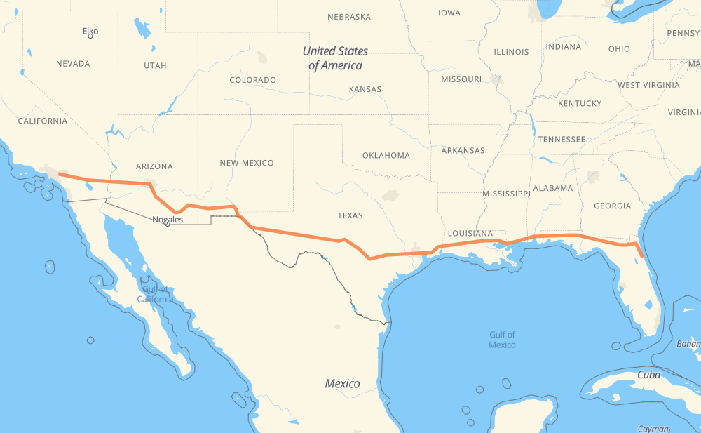
The distance from Palm Coast to Chino Hills is 3,942 kilometers by road including 3,922 kilometers on motorways. Road takes approximately 37 hours and 29 minutes and goes through Jacksonville, Tallahassee, Pensacola, Mobile, Biloxi, Gulfport and Denham Springs.
How much does it cost to drive from Palm Coast to Chino Hills?
Fuel cost:
317.8 USD
This fuel cost is calculated as: (Route length 3,942 km / 100 km) * (Fuel consumption 8.000496031746 L/100 km) * (Fuel price 1.03819596 USD / L)
You can adjust fuel consumption and fuel price here.
How long is a car ride from Palm Coast to Chino Hills?
Driving time:
37 h 29 min
This time is calculated for driving at the maximum permitted speed, taking into account traffic rules restrictions.
2,856 km with a maximum speed 109 km/h = 26 h 5 min
322 km with a maximum speed 105 km/h = 3 h 4 min
370 km with a maximum speed 100 km/h = 3 h 41 min
120 km with a maximum speed 97 km/h = 1 h 14 min
14 km with a maximum speed 90 km/h = 9 min
37 km with a maximum speed 89 km/h = 24 min
3 km with a maximum speed 80 km/h = 2 min
217 km with a maximum speed 80 km/h = 2 h 42 min
2 km with a maximum speed 72 km/h = 1 min
The calculated driving time does not take into account intermediate stops and traffic jams.
How far is Palm Coast to Chino Hills by land?
The distance between Palm Coast and Chino Hills is 3,942 km by road including 3,922 km on motorways.
Precise satellite coordinates of highways were used for this calculation. The start and finish points are the centers of Palm Coast and Chino Hills respectively.
How far is Palm Coast to Chino Hills by plane?
The shortest distance (air line, as the crow flies) between Palm Coast and Chino Hills is 3,472 km.
This distance is calculated using the Haversine formula as a great-circle distance between two points on the surface of a sphere. The start and finish points are the centers of Palm Coast and Chino Hills respectively. Actual distance between airports may be different.
How many hours is Palm Coast from Chino Hills by plane?
Boeing 737 airliner needs 4 h 20 min to cover the distance of 3,472 km at a cruising speed of 800 km/h.
Small plane "Cessna 172" needs 15 h 46 min to flight this distance at average speed of 220 km/h.
This time is approximate and do not take into account takeoff and landing times, airport location and other real world factors.
How long is a helicopter ride from Palm Coast to Chino Hills?
Fast helicopter "Eurocopter AS350" or "Hughes OH-6 Cayuse" need 14 h 28 min to cover the distance of 3,472 km at a cruising speed of 240 km/h.
Popular "Robinson R44" needs 16 h 32 min to flight this distance at average speed of 210 km/h.
This time is approximate and do not take into account takeoff and landing times, aerodrome location and other real world factors.
What city is halfway between Palm Coast and Chino Hills?
The halfway point between Palm Coast and Chino Hills is Segovia. It is located about 6 km from the exact midpoint by road.
The distance from Segovia to Palm Coast is 1,976 km and driving will take about 18 h 32 min. The road between Segovia and Chino Hills has length 1,965 km and will take approximately 18 h 56 min.
The other cities located close to halfway point:
Buck Hollow is in 2,015 km from Palm Coast and 1,926 km from Chino Hills
Kerrville is in 1,902 km from Palm Coast and 2,039 km from Chino Hills
Comfort is in 1,882 km from Palm Coast and 2,059 km from Chino Hills
Where is Palm Coast in relation to Chino Hills?
Palm Coast is located 3,472 km east of Chino Hills.
Palm Coast has geographic coordinates: latitude 29.55414, longitude -81.22077.
Chino Hills has geographic coordinates: latitude 33.99268, longitude -117.76006.
Which highway goes from Palm Coast to Chino Hills?
The route from Palm Coast to Chino Hills follows I 10, US 70, US 180, US 90, I 12.