Distance between Piripiri and Patrocínio
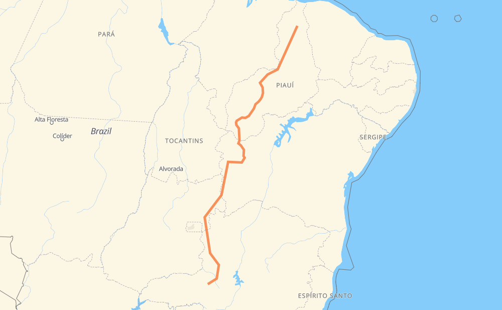
The distance from Piripiri to Patrocínio is 1,394 miles by road. Road takes approximately 25 hours and 30 minutes and goes through Agua Branca, Residencial São Francisco, Loteamento Ondas Ville, Cerradão, Condominio Rural Recanto Pache, Novo Paraná and Distrito de JK.
| Shortest distance by air | 1,073 mi ✈️ |
| Car route length | 1,393.7 mi 🚗 |
| Driving time | 25 h 30 min |
| Fuel amount | 47.4 gal |
| Fuel cost | 184.9 USD |
| Point | Distance | Time | Fuel | |
| -4.27323, -41.77852 | 0 mi | 00 min | 0.0 gal | |
|
BR-343 157 mi, 2 h 58 min
|
||||
| Agua Branca | 157 mi | 2 h 58 min | 10.5 gal | |
|
BR-343 BR-135 598 mi, 10 h 44 min
|
||||
| Residencial São Francisco | 754 mi | 13 h 42 min | 30.8 gal | |
|
BR-020 14 mi, 16 min
|
||||
| Loteamento Ondas Ville | 769 mi | 13 h 59 min | 31.1 gal | |
|
BR-020 23 mi, 27 min
|
||||
| Cerradão | 792 mi | 14 h 27 min | 31.7 gal | |
|
BR-020 27 mi, 32 min
|
||||
| Condominio Rural Recanto Pache | 819 mi | 14 h 59 min | 33.0 gal | |
|
BR-020 10 mi, 11 min
|
||||
| Novo Paraná | 829 mi | 15 h 11 min | 33.3 gal | |
|
BR-020 236 mi, 4 h 16 min
|
||||
| Distrito de JK | 1,066 mi | 19 h 27 min | 41.2 gal | |
|
BR-020 16 mi, 19 min
|
||||
| Distrito do Bezerra | 1,081 mi | 19 h 46 min | 41.7 gal | |
|
BR-020 GO-346 73 mi, 1 h 21 min
|
||||
| Santa Clara | 1,154 mi | 21 h 07 min | 44.3 gal | |
|
MG-188 175 mi, 3 h 09 min
|
||||
| Presidente Olegário | 1,329 mi | 24 h 17 min | 50.2 gal | |
|
BR-354 BR-365 65 mi, 1 h 12 min
|
||||
| -18.94083, -46.99266 | 1,394 mi | 25 h 30 min | 52.6 gal | |
Hotels of Patrocínio
Frequently Asked Questions
How much does it cost to drive from Piripiri to Patrocínio?
Fuel cost: 184.9 USD
This fuel cost is calculated as: (Route length 1,393.7 mi) / (Fuel consumption 29.4 mpg) * (Fuel price 3.9 USD / gal)
You can adjust fuel consumption and fuel price here.
How long is a car ride from Piripiri to Patrocínio?
Driving time: 25 h 30 min
This time is calculated for driving at the maximum permitted speed, taking into account traffic rules restrictions.
- 1,136 mi with a maximum speed 56 mph = 20 h 17 min
- 255 mi with a maximum speed 50 mph = 5 h 7 min
- 2 mi with a maximum speed 37 mph = 4 min
The calculated driving time does not take into account intermediate stops and traffic jams.
How far is Piripiri to Patrocínio by land?
The distance between Piripiri and Patrocínio is 1,393.7 mi by road.
Precise satellite coordinates of highways were used for this calculation. The start and finish points are the centers of Piripiri and Patrocínio respectively.
How far is Piripiri to Patrocínio by plane?
The shortest distance (air line, as the crow flies) between Piripiri and Patrocínio is 1,073.1 mi.
This distance is calculated using the Haversine formula as a great-circle distance between two points on the surface of a sphere. The start and finish points are the centers of Piripiri and Patrocínio respectively. Actual distance between airports may be different.
How many hours is Piripiri from Patrocínio by plane?
Boeing 737 airliner needs 2 h 9 min to cover the distance of 1,073 mi at a cruising speed of 497 mph.
Small plane "Cessna 172" needs 7 h 51 min to flight this distance at average speed of 136 mph.
This time is approximate and do not take into account takeoff and landing times, airport location and other real world factors.
How long is a helicopter ride from Piripiri to Patrocínio?
Fast helicopter "Eurocopter AS350" or "Hughes OH-6 Cayuse" need 7 h 11 min to cover the distance of 1,073 mi at a cruising speed of 149 mph.
Popular "Robinson R44" needs 8 h 13 min to flight this distance at average speed of 130 mph.
This time is approximate and do not take into account takeoff and landing times, aerodrome location and other real world factors.
What city is halfway between Piripiri and Patrocínio?
The halfway point between Piripiri and Patrocínio is Residencial São Francisco. It is located about 57 mi from the exact midpoint by road.
The distance from Residencial São Francisco to Piripiri is 754 mi and driving will take about 13 h 42 min. The road between Residencial São Francisco and Patrocínio has length 639 mi and will take approximately 11 h 47 min.
The other cities located close to halfway point:
Where is Piripiri in relation to Patrocínio?
Piripiri is located 1,073 mi north-east of Patrocínio.
Piripiri has geographic coordinates: latitude -4.27323, longitude -41.77852.
Patrocínio has geographic coordinates: latitude -18.94083, longitude -46.99266.
Which highway goes from Piripiri to Patrocínio?
The route from Piripiri to Patrocínio follows BR-135, BR-020, BR-343, PI-250, MG-188.
Other minor sections pass along the road:
- BR-242: 55 mi
- MG-410: 49 mi
- BR-040: 47 mi
- BR-365: 41 mi
- BR-316: 40 mi
- BR-354: 29 mi
- GO-346: 26 mi
- BR-251: 17 mi
- PI-368: 17 mi
- GO-108: 9 mi
- BR-479: 9 mi
- GO-591: 7 mi
- BR-230: 5 mi
- MGC-354: 4 mi
- PI-394: 4 mi
- BR-226: 1 mi
- PI-140: 1 mi