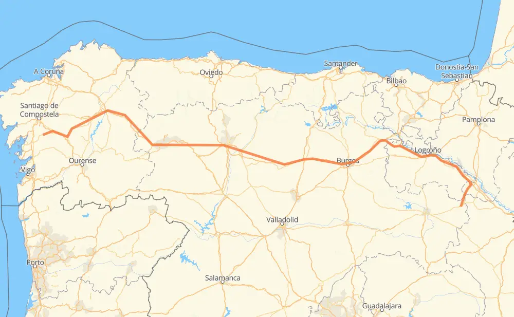
The distance from Ágreda to A Estrada is 452 miles by road including 364 miles on motorways. Road takes approximately 7 hours and 5 minutes and goes through Valverde, Cintruénigo, Calahorra, Haro, Briviesca, Carrión de los Condes and Sahagún.
You can adjust fuel consumption and fuel price here.
How long is a car ride from Ágreda to A Estrada?
Driving time:
7 h 5 min
This time is calculated for driving at the maximum permitted speed, taking into account traffic rules restrictions.
345 mi with a maximum speed 68 mph = 5 h 4 min
14 mi with a maximum speed 62 mph = 13 min
22 mi with a maximum speed 56 mph = 23 min
35 mi with a maximum speed 56 mph = 37 min
32 mi with a maximum speed 50 mph = 38 min
2 mi with a maximum speed 31 mph = 4 min
1 mi with a maximum speed 25 mph = 2 min
The calculated driving time does not take into account intermediate stops and traffic jams.
How far is Ágreda to A Estrada by land?
The distance between Ágreda and A Estrada is 451.7 mi by road including 364.1 mi on motorways.
Precise satellite coordinates of highways were used for this calculation. The start and finish points are the centers of Ágreda and A Estrada respectively.
How far is Ágreda to A Estrada by plane?
The shortest distance (air line, as the crow flies) between Ágreda and A Estrada is 340.5 mi.
This distance is calculated using the Haversine formula as a great-circle distance between two points on the surface of a sphere. The start and finish points are the centers of Ágreda and A Estrada respectively. Actual distance between airports may be different.
How many hours is Ágreda from A Estrada by plane?
Boeing 737 airliner needs 41 min to cover the distance of 341 mi at a cruising speed of 497 mph.
Small plane "Cessna 172" needs 2 h 29 min to flight this distance at average speed of 136 mph.
This time is approximate and do not take into account takeoff and landing times, airport location and other real world factors.
How long is a helicopter ride from Ágreda to A Estrada?
Fast helicopter "Eurocopter AS350" or "Hughes OH-6 Cayuse" need 2 h 17 min to cover the distance of 341 mi at a cruising speed of 149 mph.
Popular "Robinson R44" needs 2 h 36 min to flight this distance at average speed of 130 mph.
This time is approximate and do not take into account takeoff and landing times, aerodrome location and other real world factors.
What city is halfway between Ágreda and A Estrada?
The halfway point between Ágreda and A Estrada is Bercianos del Real Camino. It is located about 2 mi from the exact midpoint by road.
The distance from Bercianos del Real Camino to Ágreda is 227 mi and driving will take about 3 h 30 min. The road between Bercianos del Real Camino and A Estrada has length 224 mi and will take approximately 3 h 34 min.
The other cities located close to halfway point:
Sahagún is in 222 mi from Ágreda and 231 mi from A Estrada
Villamarco is in 234 mi from Ágreda and 219 mi from A Estrada
Moratinos is in 214 mi from Ágreda and 238 mi from A Estrada
Where is Ágreda in relation to A Estrada?
Ágreda is located 341 mi east of A Estrada.
Ágreda has geographic coordinates: latitude 41.85485, longitude -1.92146.
A Estrada has geographic coordinates: latitude 42.68801, longitude -8.49071.
Which highway goes from Ágreda to A Estrada?
The route from Ágreda to A Estrada follows A-6, A-231, AP-68.