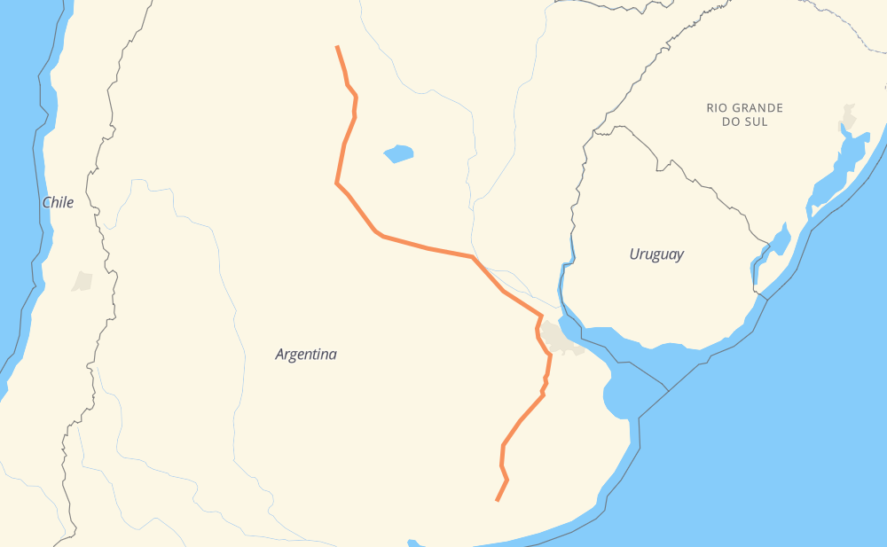
Distance between Adolfo Gonzales Chaves and Loreto
The distance from Adolfo Gonzales Chaves to Loreto is 923 miles by road including 385 miles on motorways. Road takes approximately 15 hours and 57 minutes and goes through Rosario, Córdoba, Las Flores, San Miguel del Monte, Cañuelas, Parque Sakura and Campana.
| Shortest distance by air | 713 mi ✈️ |
| Car route length | 922.7 mi 🚗 |
| Driving time | 15 h 57 min |
| Fuel amount | 31.4 gal |
| Fuel cost | 123.3 USD |
| Point | Distance | Time | Fuel | |
| Adolfo Gonzales Chaves | 0 mi | 00 min | 0.0 gal | |
|
RN3 165 mi, 3 h 03 min
|
||||
| Las Flores | 165 mi | 3 h 03 min | 5.6 gal | |
|
RN3 47 mi, 51 min
|
||||
| San Miguel del Monte | 212 mi | 3 h 55 min | 7.1 gal | |
|
RN3 29 mi, 32 min
|
||||
| Cañuelas | 240 mi | 4 h 28 min | 8.1 gal | |
|
RN3 RP6 52 mi, 58 min
|
||||
| Parque Sakura | 293 mi | 5 h 26 min | 9.9 gal | |
|
RP6 17 mi, 19 min
|
||||
| Campana | 309 mi | 5 h 45 min | 10.5 gal | |
|
RP6 RN9 135 mi, 2 h 00 min
|
||||
| Rosario | 446 mi | 7 h 46 min | 15.0 gal | |
|
RNA008 RN9 9 mi, 08 min
|
||||
| Funes | 455 mi | 7 h 55 min | 15.4 gal | |
|
RN9 235 mi, 3 h 29 min
|
||||
| Córdoba | 690 mi | 11 h 24 min | 23.0 gal | |
|
RN9 233 mi, 4 h 33 min
|
||||
| Loreto | 923 mi | 15 h 57 min | 29.9 gal | |
Frequently Asked Questions
How much does it cost to drive from Adolfo Gonzales Chaves to Loreto?
Fuel cost: 123.3 USD
This fuel cost is calculated as: (Route length 922.7 mi) / (Fuel consumption 29.4 mpg) * (Fuel price 3.93 USD / gal)
You can adjust fuel consumption and fuel price here.
How long is a car ride from Adolfo Gonzales Chaves to Loreto?
Driving time: 15 h 57 min
This time is calculated for driving at the maximum permitted speed, taking into account traffic rules restrictions.
- 377 mi with a maximum speed 68 mph = 5 h 32 min
- 6 mi with a maximum speed 62 mph = 5 min
- 311 mi with a maximum speed 56 mph = 5 h 33 min
- 209 mi with a maximum speed 50 mph = 4 h 11 min
- 16 mi with a maximum speed 37 mph = 26 min
- 3 mi with a maximum speed 25 mph = 7 min
The calculated driving time does not take into account intermediate stops and traffic jams.
How far is Adolfo Gonzales Chaves to Loreto by land?
The distance between Adolfo Gonzales Chaves and Loreto is 922.7 mi by road including 385.3 mi on motorways.
Precise satellite coordinates of highways were used for this calculation. The start and finish points are the centers of Adolfo Gonzales Chaves and Loreto respectively.
How far is Adolfo Gonzales Chaves to Loreto by plane?
The shortest distance (air line, as the crow flies) between Adolfo Gonzales Chaves and Loreto is 712.7 mi.
This distance is calculated using the Haversine formula as a great-circle distance between two points on the surface of a sphere. The start and finish points are the centers of Adolfo Gonzales Chaves and Loreto respectively. Actual distance between airports may be different.
How many hours is Adolfo Gonzales Chaves from Loreto by plane?
Boeing 737 airliner needs 1 h 26 min to cover the distance of 713 mi at a cruising speed of 497 mph.
Small plane "Cessna 172" needs 5 h 12 min to flight this distance at average speed of 136 mph.
This time is approximate and do not take into account takeoff and landing times, airport location and other real world factors.
How long is a helicopter ride from Adolfo Gonzales Chaves to Loreto?
Fast helicopter "Eurocopter AS350" or "Hughes OH-6 Cayuse" need 4 h 46 min to cover the distance of 713 mi at a cruising speed of 149 mph.
Popular "Robinson R44" needs 5 h 27 min to flight this distance at average speed of 130 mph.
This time is approximate and do not take into account takeoff and landing times, aerodrome location and other real world factors.
What city is halfway between Adolfo Gonzales Chaves and Loreto?
The halfway point between Adolfo Gonzales Chaves and Loreto is Funes. It is located about 7 mi from the exact midpoint by road.
The distance from Funes to Adolfo Gonzales Chaves is 455 mi and driving will take about 7 h 55 min. The road between Funes and Loreto has length 468 mi and will take approximately 8 h 2 min.
The other cities located close to halfway point:
Where is Adolfo Gonzales Chaves in relation to Loreto?
Adolfo Gonzales Chaves is located 713 mi south-east of Loreto.
Adolfo Gonzales Chaves has geographic coordinates: latitude -38.03308, longitude -60.09997.
Loreto has geographic coordinates: latitude -28.30096, longitude -64.18419.
Which highway goes from Adolfo Gonzales Chaves to Loreto?
The route from Adolfo Gonzales Chaves to Loreto follows RN9, RN3, RP6.
Other minor sections pass along the road:
- RN2V9: 9 mi
- RNA019: 7 mi
- RNA008: 6 mi
- RP40: 1 mi
- RP75: 1 mi