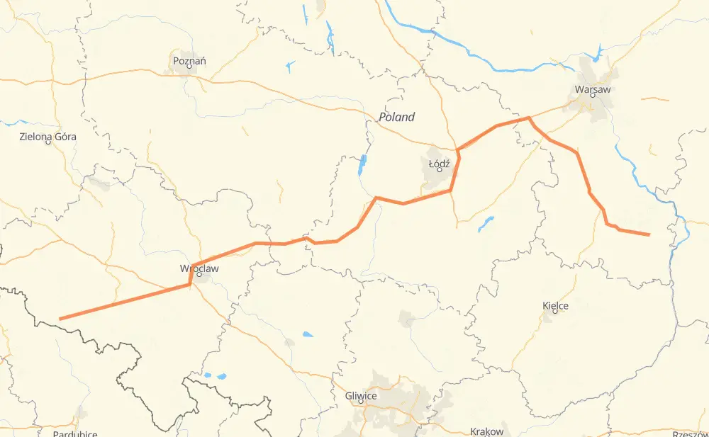
The distance from Agnetendorf to Zwoleń is 347 miles by road including 84 miles on motorways. Road takes approximately 6 hours and 25 minutes and goes through Hirschberg, Hermsdorf unterm Kynast, Grabary, Bolkenhain, Striegau, Kanth and Groß Wartenberg.
You can adjust fuel consumption and fuel price here.
How long is a car ride from Agnetendorf to Zwoleń?
Driving time:
6 h 25 min
This time is calculated for driving at the maximum permitted speed, taking into account traffic rules restrictions.
80 mi with a maximum speed 68 mph = 1 h 10 min
158 mi with a maximum speed 56 mph = 2 h 49 min
60 mi with a maximum speed 56 mph = 1 h 4 min
9 mi with a maximum speed 50 mph = 10 min
11 mi with a maximum speed 43 mph = 15 min
2 mi with a maximum speed 37 mph = 2 min
25 mi with a maximum speed 31 mph = 49 min
2 mi with a maximum speed 25 mph = 3 min
The calculated driving time does not take into account intermediate stops and traffic jams.
How far is Agnetendorf to Zwoleń by land?
The distance between Agnetendorf and Zwoleń is 346.7 mi by road including 83.9 mi on motorways.
Precise satellite coordinates of highways were used for this calculation. The start and finish points are the centers of Agnetendorf and Zwoleń respectively.
How far is Agnetendorf to Zwoleń by plane?
The shortest distance (air line, as the crow flies) between Agnetendorf and Zwoleń is 261.6 mi.
This distance is calculated using the Haversine formula as a great-circle distance between two points on the surface of a sphere. The start and finish points are the centers of Agnetendorf and Zwoleń respectively. Actual distance between airports may be different.
How many hours is Agnetendorf from Zwoleń by plane?
Boeing 737 airliner needs 31 min to cover the distance of 262 mi at a cruising speed of 497 mph.
Small plane "Cessna 172" needs 1 h 54 min to flight this distance at average speed of 136 mph.
This time is approximate and do not take into account takeoff and landing times, airport location and other real world factors.
How long is a helicopter ride from Agnetendorf to Zwoleń?
Fast helicopter "Eurocopter AS350" or "Hughes OH-6 Cayuse" need 1 h 45 min to cover the distance of 262 mi at a cruising speed of 149 mph.
Popular "Robinson R44" needs 2 h to flight this distance at average speed of 130 mph.
This time is approximate and do not take into account takeoff and landing times, aerodrome location and other real world factors.
What city is halfway between Agnetendorf and Zwoleń?
The halfway point between Agnetendorf and Zwoleń is Wiechutki. It is located about 1 mi from the exact midpoint by road.
The distance from Wiechutki to Agnetendorf is 173 mi and driving will take about 3 h 16 min. The road between Wiechutki and Zwoleń has length 174 mi and will take approximately 3 h 9 min.
The other cities located close to halfway point:
Kaźmierzec is in 177 mi from Agnetendorf and 169 mi from Zwoleń
Poręby is in 180 mi from Agnetendorf and 167 mi from Zwoleń
Ruszków is in 166 mi from Agnetendorf and 180 mi from Zwoleń
Where is Agnetendorf in relation to Zwoleń?
Agnetendorf is located 262 mi west of Zwoleń.
Agnetendorf has geographic coordinates: latitude 50.82204, longitude 15.61713.
Zwoleń has geographic coordinates: latitude 51.35647, longitude 21.58447.