Distance between Alterosa and Cotriguaçu
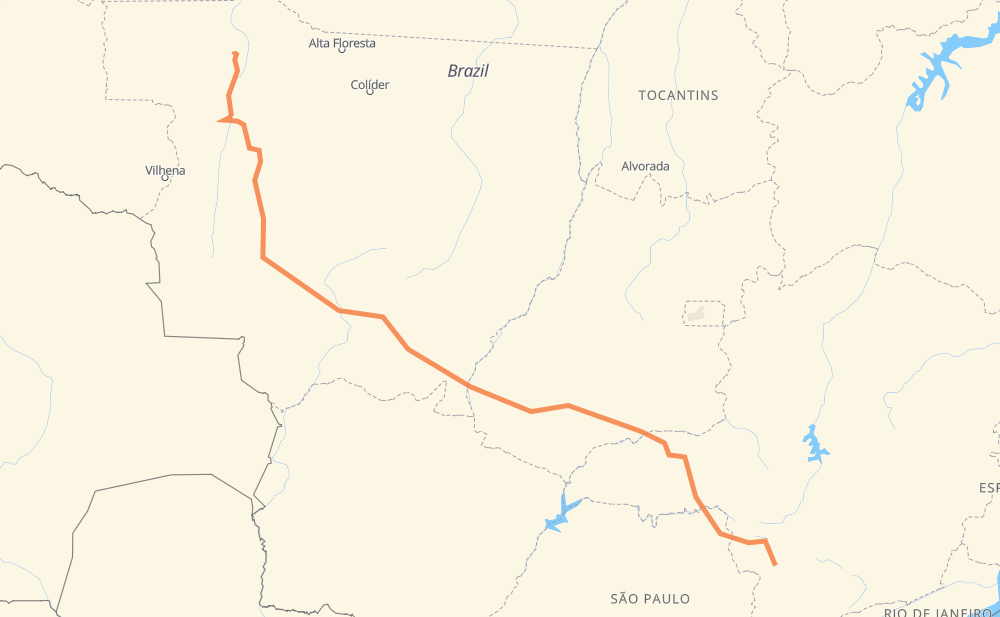
The distance from Alterosa to Cotriguaçu is 1,506 miles by road including 203 miles on motorways. Road takes approximately 27 hours and 38 minutes and goes through Carmo do Rio Claro, Alpinópolis, Itaú de Minas, São José, Jardim Vera Cruz III, Jardim Itália and São Cristóvão.
| Shortest distance by air | 1,138 mi ✈️ |
| Car route length | 1,505.6 mi 🚗 |
| Driving time | 27 h 38 min |
| Fuel amount | 51.2 gal |
| Fuel cost | 199.7 USD |
| Point | Distance | Time | Fuel | |
| Alterosa | 0 mi | 00 min | 0.0 gal | |
|
MG-184 22 mi, 26 min
|
||||
| Carmo do Rio Claro | 22 mi | 26 min | 0.7 gal | |
|
MG-184 BR-265 19 mi, 23 min
|
||||
| Alpinópolis | 40 mi | 50 min | 1.1 gal | |
|
MG-446 MG-050 37 mi, 41 min
|
||||
| Itaú de Minas | 76 mi | 1 h 31 min | 2.4 gal | |
|
MG-050 MG-344 20 mi, 22 min
|
||||
| São José | 97 mi | 1 h 54 min | 3.2 gal | |
|
MG-444 SP-345 40 mi, 42 min
|
||||
| Jardim Vera Cruz III | 137 mi | 2 h 37 min | 4.5 gal | |
|
SP-334 BR-050 66 mi, 1 h 10 min
|
||||
| Jardim Itália | 203 mi | 3 h 47 min | 6.8 gal | |
|
BR-050 3 mi, 03 min
|
||||
| São Cristóvão | 206 mi | 3 h 50 min | 7.0 gal | |
|
BR-050 80 mi, 1 h 14 min
|
||||
| Tocantins | 286 mi | 5 h 05 min | 9.5 gal | |
|
BR-365 MG-452 30 mi, 31 min
|
||||
| Tupaciguara | 316 mi | 5 h 36 min | 10.4 gal | |
|
BR-452 BR-364 1,192 mi, 22 h 01 min
|
||||
| -9.90347, -58.56588 | 1,508 mi | 27 h 38 min | 51.3 gal | |
Frequently Asked Questions
How much does it cost to drive from Alterosa to Cotriguaçu?
Fuel cost: 199.7 USD
This fuel cost is calculated as: (Route length 1,505.6 mi) / (Fuel consumption 29.4 mpg) * (Fuel price 3.9 USD / gal)
You can adjust fuel consumption and fuel price here.
How long is a car ride from Alterosa to Cotriguaçu?
Driving time: 27 h 38 min
This time is calculated for driving at the maximum permitted speed, taking into account traffic rules restrictions.
- 74 mi with a maximum speed 68 mph = 1 h 5 min
- 111 mi with a maximum speed 62 mph = 1 h 47 min
- 880 mi with a maximum speed 56 mph = 15 h 43 min
- 429 mi with a maximum speed 50 mph = 8 h 38 min
- 7 mi with a maximum speed 37 mph = 11 min
- 2 mi with a maximum speed 31 mph = 4 min
- 4 mi with a maximum speed 25 mph = 8 min
The calculated driving time does not take into account intermediate stops and traffic jams.
How far is Alterosa to Cotriguaçu by land?
The distance between Alterosa and Cotriguaçu is 1,505.6 mi by road including 202.6 mi on motorways.
Precise satellite coordinates of highways were used for this calculation. The start and finish points are the centers of Alterosa and Cotriguaçu respectively.
How far is Alterosa to Cotriguaçu by plane?
The shortest distance (air line, as the crow flies) between Alterosa and Cotriguaçu is 1,138.4 mi.
This distance is calculated using the Haversine formula as a great-circle distance between two points on the surface of a sphere. The start and finish points are the centers of Alterosa and Cotriguaçu respectively. Actual distance between airports may be different.
How many hours is Alterosa from Cotriguaçu by plane?
Boeing 737 airliner needs 2 h 17 min to cover the distance of 1,138 mi at a cruising speed of 497 mph.
Small plane "Cessna 172" needs 8 h 19 min to flight this distance at average speed of 136 mph.
This time is approximate and do not take into account takeoff and landing times, airport location and other real world factors.
How long is a helicopter ride from Alterosa to Cotriguaçu?
Fast helicopter "Eurocopter AS350" or "Hughes OH-6 Cayuse" need 7 h 38 min to cover the distance of 1,138 mi at a cruising speed of 149 mph.
Popular "Robinson R44" needs 8 h 43 min to flight this distance at average speed of 130 mph.
This time is approximate and do not take into account takeoff and landing times, aerodrome location and other real world factors.
What city is halfway between Alterosa and Cotriguaçu?
The halfway point between Alterosa and Cotriguaçu is Vila Goulart. It is located about 34 mi from the exact midpoint by road.
The distance from Vila Goulart to Alterosa is 786 mi and driving will take about 14 h 16 min. The road between Vila Goulart and Cotriguaçu has length 719 mi and will take approximately 13 h 22 min.
The other cities located close to halfway point:
Where is Alterosa in relation to Cotriguaçu?
Alterosa is located 1,138 mi south-east of Cotriguaçu.
Alterosa has geographic coordinates: latitude -21.24917, longitude -46.14306.
Cotriguaçu has geographic coordinates: latitude -9.90347, longitude -58.56588.
Which highway goes from Alterosa to Cotriguaçu?
The route from Alterosa to Cotriguaçu follows BR-364, MT-170, BR-452, BR-163, BR-050, MT-358.
Other minor sections pass along the road:
- BR-060: 60 mi
- BR-070: 54 mi
- MT-246: 50 mi
- MG-452: 45 mi
- MG-184: 27 mi
- MG-050: 25 mi
- BR-365: 22 mi
- SP-345: 22 mi
- MG-344: 16 mi
- SP-334: 16 mi
- MT-343: 15 mi
- MG-444: 15 mi
- MT-344: 14 mi
- MG-446: 13 mi
- BTZ-030: 13 mi
- BR-265: 12 mi
- MGC-265: 11 mi
- MT-407: 10 mi
- SP-330: 6 mi
- BR-153: 4 mi
- MT-100: 4 mi
- BR-158: 3 mi
- BR-262: 3 mi
- MGC-452: 1 mi