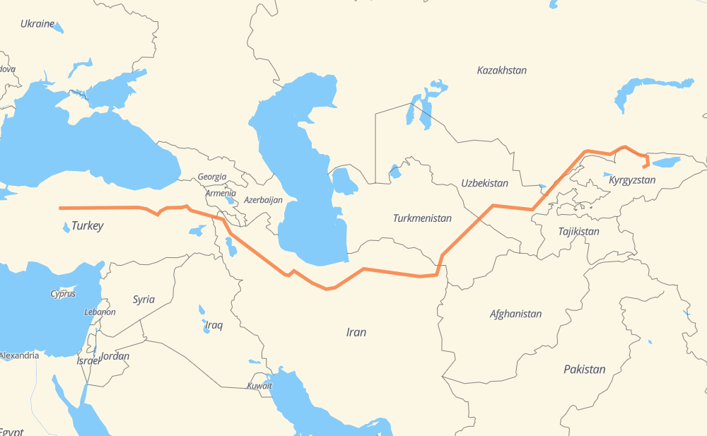
Distance between Ancara and Tuz
The distance from Ancara to Tuz is 3,155 miles by road including 390 miles on motorways. Road takes approximately 60 hours and 1 minute and goes through Yozgat, Erzincan, Ağrı, Tabriz, Zanjan, Qazvin and Karaj.
| Shortest distance by air | 2,205 mi ✈️ |
| Car route length | 3,154.7 mi 🚗 |
| Driving time | 60 h 1 min |
| Fuel amount | 107.3 gal |
| Fuel cost | 418.5 USD |
| Point | Distance | Time | Fuel | |
| Ancara | 0 mi | 00 min | 0.0 gal | |
|
D200 131 mi, 2 h 34 min
|
||||
| Yozgat | 131 mi | 2 h 34 min | 4.4 gal | |
|
D200 298 mi, 5 h 49 min
|
||||
| Erzincan | 429 mi | 8 h 23 min | 14.5 gal | |
|
D100 232 mi, 4 h 20 min
|
||||
| Ağrı | 661 mi | 12 h 44 min | 22.4 gal | |
|
D 100 32 253 mi, 4 h 46 min
|
||||
| Tabriz | 914 mi | 17 h 30 min | 30.9 gal | |
|
2 182 mi, 2 h 59 min
|
||||
| Zanjan | 1,095 mi | 20 h 29 min | 37.1 gal | |
|
2 111 mi, 1 h 37 min
|
||||
| Qazvin | 1,206 mi | 22 h 07 min | 40.9 gal | |
|
2 66 mi, 1 h 00 min
|
||||
| Karaj | 1,272 mi | 23 h 08 min | 43.2 gal | |
|
2 21 mi, 21 min
|
||||
| Tehran | 1,292 mi | 23 h 29 min | 43.3 gal | |
|
2 44 418 mi, 7 h 40 min
|
||||
| Sabzevar | 1,711 mi | 31 h 10 min | 58.1 gal | |
|
44 68 mi, 1 h 14 min
|
||||
| Neyshabur | 1,779 mi | 32 h 24 min | 60.5 gal | |
|
44 22 290 mi, 5 h 36 min
|
||||
| Merv | 2,069 mi | 38 h 00 min | 70.2 gal | |
|
M37 19 mi, 29 min
|
||||
| Baýramaly | 2,088 mi | 38 h 30 min | 70.9 gal | |
|
P-25 M37 216 mi, 5 h 04 min
|
||||
| Bukhara | 2,303 mi | 43 h 34 min | 78.2 gal | |
|
M37 167 mi, 3 h 10 min
|
||||
| Samarkand | 2,470 mi | 46 h 45 min | 83.9 gal | |
|
4P45 M39 174 mi, 3 h 18 min
|
||||
| Tashkent | 2,644 mi | 50 h 03 min | 89.7 gal | |
|
M39 A-2 80 mi, 1 h 32 min
|
||||
| Shymkent | 2,724 mi | 51 h 36 min | 92.1 gal | |
|
A-2 446 mi, 8 h 25 min
|
||||
| Tuz | 3,170 mi | 60 h 01 min | 107.8 gal | |
Frequently Asked Questions
How much does it cost to drive from Ancara to Tuz?
Fuel cost: 418.5 USD
This fuel cost is calculated as: (Route length 3,154.7 mi) / (Fuel consumption 29.4 mpg) * (Fuel price 3.9 USD / gal)
You can adjust fuel consumption and fuel price here.
How long is a car ride from Ancara to Tuz?
Driving time: 60 h 1 min
This time is calculated for driving at the maximum permitted speed, taking into account traffic rules restrictions.
- 267 mi with a maximum speed 68 mph = 3 h 55 min
- 57 mi with a maximum speed 62 mph = 55 min
- 1,176 mi with a maximum speed 56 mph = 20 h 59 min
- 370 mi with a maximum speed 56 mph = 6 h 37 min
- 1,099 mi with a maximum speed 50 mph = 22 h 6 min
- 33 mi with a maximum speed 43 mph = 45 min
- 151 mi with a maximum speed 37 mph = 4 h 3 min
- 12 mi with a maximum speed 31 mph = 22 min
- 2 mi with a maximum speed 25 mph = 6 min
- 1 mi with a maximum speed 19 mph = 1 min
- 2 mi with a maximum speed 12 mph = 8 min
The calculated driving time does not take into account intermediate stops and traffic jams.
How far is Ancara to Tuz by land?
The distance between Ancara and Tuz is 3,154.7 mi by road including 389.6 mi on motorways.
Precise satellite coordinates of highways were used for this calculation. The start and finish points are the centers of Ancara and Tuz respectively.
How far is Ancara to Tuz by plane?
The shortest distance (air line, as the crow flies) between Ancara and Tuz is 2,205.2 mi.
This distance is calculated using the Haversine formula as a great-circle distance between two points on the surface of a sphere. The start and finish points are the centers of Ancara and Tuz respectively. Actual distance between airports may be different.
How many hours is Ancara from Tuz by plane?
Boeing 737 airliner needs 4 h 26 min to cover the distance of 2,205 mi at a cruising speed of 497 mph.
Small plane "Cessna 172" needs 16 h 7 min to flight this distance at average speed of 136 mph.
This time is approximate and do not take into account takeoff and landing times, airport location and other real world factors.
How long is a helicopter ride from Ancara to Tuz?
Fast helicopter "Eurocopter AS350" or "Hughes OH-6 Cayuse" need 14 h 47 min to cover the distance of 2,205 mi at a cruising speed of 149 mph.
Popular "Robinson R44" needs 16 h 53 min to flight this distance at average speed of 130 mph.
This time is approximate and do not take into account takeoff and landing times, aerodrome location and other real world factors.
What city is halfway between Ancara and Tuz?
The halfway point between Ancara and Tuz is Mayamey. It is located about 19 mi from the exact midpoint by road.
The distance from Mayamey to Ancara is 1,596 mi and driving will take about 29 h. The road between Mayamey and Tuz has length 1,558 mi and will take approximately 31 h 1 min.
The other cities located close to halfway point:
Where is Ancara in relation to Tuz?
Ancara is located 2,205 mi west of Tuz.
Ancara has geographic coordinates: latitude 39.92152, longitude 32.85378.
Tuz has geographic coordinates: latitude 42.15487, longitude 75.49981.
Which highway goes from Ancara to Tuz?
The route from Ancara to Tuz follows 44, M37, 2, D200, A-2, M39, 32, D100, D 100, 22, ЭМ-07, A359.
Other minor sections pass along the road:
- P-7: 49 mi
- 21: 34 mi
- D 100 / D 957: 29 mi
- D850: 29 mi
- D-200: 25 mi
- E 80 / D 100: 22 mi
- D885: 20 mi
- E88: 17 mi
- D052: 16 mi
- A-359: 16 mi
- 14: 14 mi
- 48: 12 mi
- ЭМ-16: 12 mi
- D 052: 8 mi
- P-47: 6 mi
- D 100 / D 975: 4 mi
- E40: 4 mi
- 4P45: 4 mi
- 4Р4-А: 4 mi
- 87: 3 mi
- M-026: 2 mi
- 4К705: 1 mi
- D765: 1 mi
- P-25: 1 mi