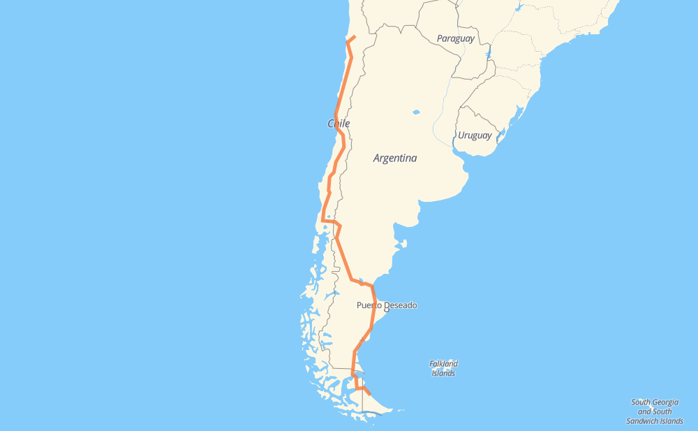
Distance between Araucana and Aeropuerto
The distance from Araucana to Aeropuerto is 2,874 miles by road including 1,141 miles on motorways. Road takes approximately 50 hours and 41 minutes and goes through Antofagasta, Copiapó, Vallenar, La Serena, Coquimbo, Ovalle and Colina.
| Shortest distance by air | 2,123 mi ✈️ |
| Car route length | 2,873.8 mi 🚗 |
| Driving time | 50 h 41 min |
| Fuel amount | 97.8 gal |
| Fuel cost | 381.3 USD |
| Point | Distance | Time | Fuel | |
| -23.08358, -69.44906 | 0 mi | 00 min | 0.0 gal | |
|
5 99 mi, 2 h 01 min
|
||||
| Antofagasta | 99 mi | 2 h 01 min | 3.1 gal | |
|
5 341 mi, 6 h 07 min
|
||||
| Copiapó | 439 mi | 8 h 08 min | 15.3 gal | |
|
5 89 mi, 1 h 29 min
|
||||
| Vallenar | 529 mi | 9 h 38 min | 17.7 gal | |
|
5 98 mi, 1 h 40 min
|
||||
| La Serena | 627 mi | 11 h 19 min | 22.5 gal | |
|
5 30 mi, 31 min
|
||||
| Coquimbo | 657 mi | 11 h 50 min | 23.2 gal | |
|
5 49 mi, 44 min
|
||||
| Ovalle | 706 mi | 12 h 35 min | 24.5 gal | |
|
5 232 mi, 3 h 31 min
|
||||
| San Bernardo | 939 mi | 16 h 06 min | 33.3 gal | |
|
5 40 mi, 36 min
|
||||
| Rancagua | 979 mi | 16 h 43 min | 34.7 gal | |
|
5 29 mi, 26 min
|
||||
| San Fernando | 1,008 mi | 17 h 09 min | 35.6 gal | |
|
5 34 mi, 31 min
|
||||
| Curicó | 1,043 mi | 17 h 41 min | 36.8 gal | |
|
5 40 mi, 35 min
|
||||
| Talca | 1,083 mi | 18 h 17 min | 38.2 gal | |
|
5 30 mi, 26 min
|
||||
| Linares | 1,113 mi | 18 h 43 min | 39.3 gal | |
|
5 62 mi, 55 min
|
||||
| Chillán | 1,176 mi | 19 h 39 min | 41.4 gal | |
|
5 65 mi, 57 min
|
||||
| Los Ángeles | 1,241 mi | 20 h 37 min | 43.2 gal | |
|
5 99 mi, 1 h 29 min
|
||||
| Temuco | 1,340 mi | 22 h 06 min | 47.1 gal | |
|
5 165 mi, 2 h 31 min
|
||||
| Osorno | 1,505 mi | 24 h 38 min | 52.4 gal | |
|
215-CH 147 mi, 2 h 56 min
|
||||
| San Carlos de Bariloche | 1,652 mi | 27 h 34 min | 57.6 gal | |
|
RP237 RN3 1,223 mi, 23 h 06 min
|
||||
| -53.78125, -67.75536 | 2,874 mi | 50 h 40 min | 99.3 gal | |
Frequently Asked Questions
How much does it cost to drive from Araucana to Aeropuerto?
Fuel cost: 381.3 USD
This fuel cost is calculated as: (Route length 2,873.8 mi) / (Fuel consumption 29.4 mpg) * (Fuel price 3.9 USD / gal)
You can adjust fuel consumption and fuel price here.
How long is a car ride from Araucana to Aeropuerto?
Driving time: 50 h 41 min
This time is calculated for driving at the maximum permitted speed, taking into account traffic rules restrictions.
- 841 mi with a maximum speed 68 mph = 12 h 22 min
- 232 mi with a maximum speed 62 mph = 3 h 44 min
- 1,156 mi with a maximum speed 56 mph = 20 h 39 min
- 2 mi with a maximum speed 56 mph = 2 min
- 579 mi with a maximum speed 50 mph = 11 h 39 min
- 4 mi with a maximum speed 43 mph = 5 min
- 39 mi with a maximum speed 37 mph = 1 h 3 min
- 7 mi with a maximum speed 31 mph = 12 min
- 3 mi with a maximum speed 25 mph = 6 min
- 9 mi with a maximum speed 12 mph = 44 min
The calculated driving time does not take into account intermediate stops and traffic jams.
How far is Araucana to Aeropuerto by land?
The distance between Araucana and Aeropuerto is 2,873.8 mi by road including 1,141.5 mi on motorways.
Precise satellite coordinates of highways were used for this calculation. The start and finish points are the centers of Araucana and Aeropuerto respectively.
How far is Araucana to Aeropuerto by plane?
The shortest distance (air line, as the crow flies) between Araucana and Aeropuerto is 2,123.2 mi.
This distance is calculated using the Haversine formula as a great-circle distance between two points on the surface of a sphere. The start and finish points are the centers of Araucana and Aeropuerto respectively. Actual distance between airports may be different.
How many hours is Araucana from Aeropuerto by plane?
Boeing 737 airliner needs 4 h 16 min to cover the distance of 2,123 mi at a cruising speed of 497 mph.
Small plane "Cessna 172" needs 15 h 31 min to flight this distance at average speed of 136 mph.
This time is approximate and do not take into account takeoff and landing times, airport location and other real world factors.
How long is a helicopter ride from Araucana to Aeropuerto?
Fast helicopter "Eurocopter AS350" or "Hughes OH-6 Cayuse" need 14 h 14 min to cover the distance of 2,123 mi at a cruising speed of 149 mph.
Popular "Robinson R44" needs 16 h 16 min to flight this distance at average speed of 130 mph.
This time is approximate and do not take into account takeoff and landing times, aerodrome location and other real world factors.
What city is halfway between Araucana and Aeropuerto?
The halfway point between Araucana and Aeropuerto is Los Lagos. It is located about 11 mi from the exact midpoint by road.
The distance from Los Lagos to Araucana is 1,448 mi and driving will take about 23 h 42 min. The road between Los Lagos and Aeropuerto has length 1,425 mi and will take approximately 26 h 58 min.
The other cities located close to halfway point:
Where is Araucana in relation to Aeropuerto?
Araucana is located 2,123 mi north of Aeropuerto.
Araucana has geographic coordinates: latitude -23.08358, longitude -69.44906.
Aeropuerto has geographic coordinates: latitude -53.78125, longitude -67.75536.
Which highway goes from Araucana to Aeropuerto?
The route from Araucana to Aeropuerto follows 5, RN3, RN40, RN26, 257-CH, 215-CH.
Other minor sections pass along the road:
- 255-CH: 24 mi
- RN231: 19 mi
- 25: 18 mi
- 74: 13 mi
- RP1: 7 mi
- RN288: 6 mi
- RN2V3: 6 mi
- Y-663: 5 mi
- RP237: 4 mi
- RP7: 3 mi
- RP5: 1 mi