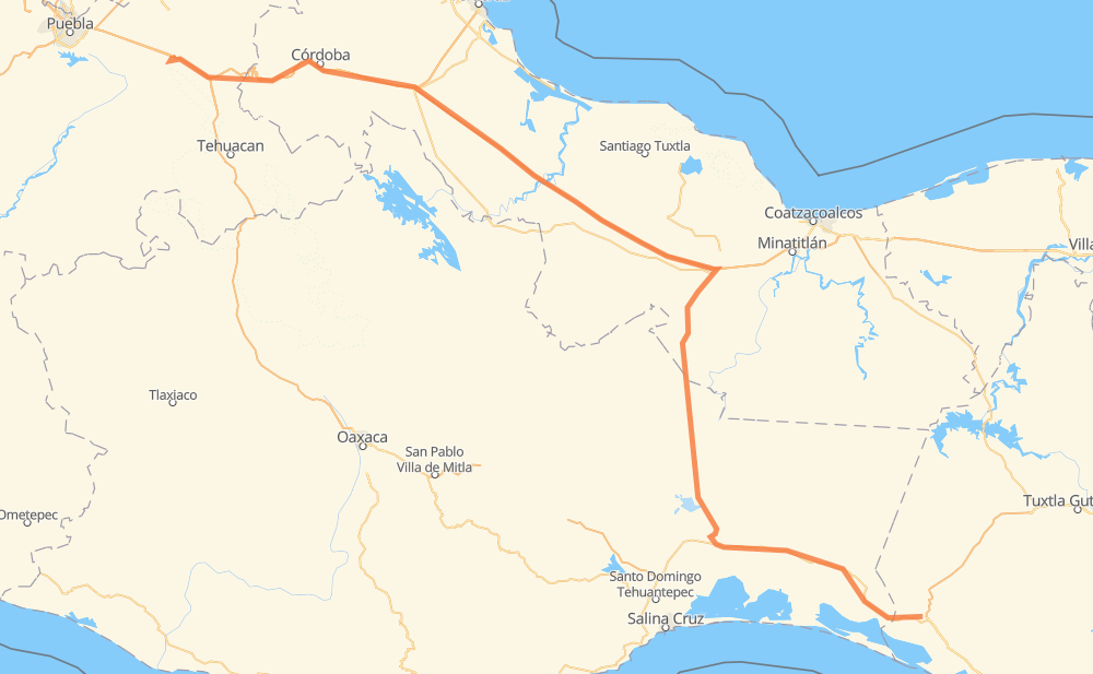
Distance between Arriaga and Francisco I. Madero
The distance from Arriaga to Francisco I. Madero is 414 miles by road including 218 miles on motorways. Road takes approximately 7 hours and 35 minutes and goes through Orizaba, San Pedro Tapanatepec, Santo Domingo Zanatepec, Santo Domingo Ingenio, Sayula de Alemán, Ixtaczoquitlán and Nogales.
| Shortest distance by air | 311 mi ✈️ |
| Car route length | 414.5 mi 🚗 |
| Driving time | 7 h 35 min |
| Fuel amount | 14.1 gal |
| Fuel cost | 54.9 USD |
| Toll roads cost | 516 + ? MXN |
| Point | Distance | Time | Fuel | |
| Arriaga | 0 mi | 00 min | 0.0 gal | |
|
MEX 200 27 mi, 30 min
|
||||
| San Pedro Tapanatepec | 27 mi | 30 min | 0.8 gal | |
|
MEX 200 MEX 190 15 mi, 17 min
|
||||
| Santo Domingo Zanatepec | 42 mi | 47 min | 1.3 gal | |
|
MEX 190 29 mi, 31 min
|
||||
| Santo Domingo Ingenio | 70 mi | 1 h 19 min | 2.3 gal | |
|
MEX 190 MEX 185 116 mi, 2 h 22 min
|
||||
| Sayula de Alemán | 187 mi | 3 h 41 min | 6.3 gal | |
|
MEX 185 MEX 145D 164 mi, 2 h 37 min
|
||||
| Ixtaczoquitlán | 350 mi | 6 h 19 min | 11.9 gal | |
|
MEX 150D 3 mi, 03 min
|
||||
| Orizaba | 354 mi | 6 h 23 min | 11.9 gal | |
|
MEX 150D 4 mi, 05 min
|
||||
| Nogales | 359 mi | 6 h 28 min | 12.1 gal | |
|
MEX 150D 40 mi, 48 min
|
||||
| Cuacnopalan | 399 mi | 7 h 16 min | 13.4 gal | |
|
MEX 150D 16 mi, 18 min
|
||||
| Francisco I. Madero | 414 mi | 7 h 35 min | 14.1 gal | |
Frequently Asked Questions
How many toll booths are there from Arriaga to Francisco I. Madero?
There are 5 toll booths between Arriaga and Francisco I. Madero: Fortín, Cuitláhuac, Cosamaloapan, Acayucan and Esperanza 27.
How much does the toll booths cost from Arriaga to Francisco I. Madero?
Toll roads cost: Acayucan (?) + Cosamaloapan (229 MXN) + Cuitláhuac (114 MXN) + Fortín (33 MXN) + Esperanza 27 (140 MXN) = 516 + ? MXN
How much does it cost to drive from Arriaga to Francisco I. Madero?
Fuel cost: 54.9 USD
This fuel cost is calculated as: (Route length 414.5 mi) / (Fuel consumption 29.4 mpg) * (Fuel price 3.9 USD / gal)
You can adjust fuel consumption and fuel price here.
Toll roads cost: 516 + ? MXN
How long is a car ride from Arriaga to Francisco I. Madero?
Driving time: 7 h 35 min
This time is calculated for driving at the maximum permitted speed, taking into account traffic rules restrictions.
- 38 mi with a maximum speed 68 mph = 33 min
- 118 mi with a maximum speed 62 mph = 1 h 54 min
- 51 mi with a maximum speed 56 mph = 54 min
- 190 mi with a maximum speed 50 mph = 3 h 49 min
- 17 mi with a maximum speed 43 mph = 23 min
The calculated driving time does not take into account intermediate stops and traffic jams.
How far is Arriaga to Francisco I. Madero by land?
The distance between Arriaga and Francisco I. Madero is 414.5 mi by road including 218.1 mi on motorways.
Precise satellite coordinates of highways were used for this calculation. The start and finish points are the centers of Arriaga and Francisco I. Madero respectively.
How far is Arriaga to Francisco I. Madero by plane?
The shortest distance (air line, as the crow flies) between Arriaga and Francisco I. Madero is 311.3 mi.
This distance is calculated using the Haversine formula as a great-circle distance between two points on the surface of a sphere. The start and finish points are the centers of Arriaga and Francisco I. Madero respectively. Actual distance between airports may be different.
How many hours is Arriaga from Francisco I. Madero by plane?
Boeing 737 airliner needs 37 min to cover the distance of 311 mi at a cruising speed of 497 mph.
Small plane "Cessna 172" needs 2 h 16 min to flight this distance at average speed of 136 mph.
This time is approximate and do not take into account takeoff and landing times, airport location and other real world factors.
How long is a helicopter ride from Arriaga to Francisco I. Madero?
Fast helicopter "Eurocopter AS350" or "Hughes OH-6 Cayuse" need 2 h 5 min to cover the distance of 311 mi at a cruising speed of 149 mph.
Popular "Robinson R44" needs 2 h 23 min to flight this distance at average speed of 130 mph.
This time is approximate and do not take into account takeoff and landing times, aerodrome location and other real world factors.
What city is halfway between Arriaga and Francisco I. Madero?
The halfway point between Arriaga and Francisco I. Madero is Sayula de Alemán. It is located about 21 mi from the exact midpoint by road.
The distance from Sayula de Alemán to Arriaga is 187 mi and driving will take about 3 h 41 min. The road between Sayula de Alemán and Francisco I. Madero has length 227 mi and will take approximately 3 h 53 min.
The other cities located close to halfway point:
Where is Arriaga in relation to Francisco I. Madero?
Arriaga is located 311 mi south-east of Francisco I. Madero.
Arriaga has geographic coordinates: latitude 16.23527, longitude -93.89969.
Francisco I. Madero has geographic coordinates: latitude 18.93, longitude -97.68333.
Which highway goes from Arriaga to Francisco I. Madero?
The route from Arriaga to Francisco I. Madero follows MEX 145D, MEX 185, MEX 150D.
Other minor sections pass along the road:
- MEX 190: 50 mi
- MEX 200: 29 mi
- MEX 185D: 4 mi
- PUE 714: 2 mi