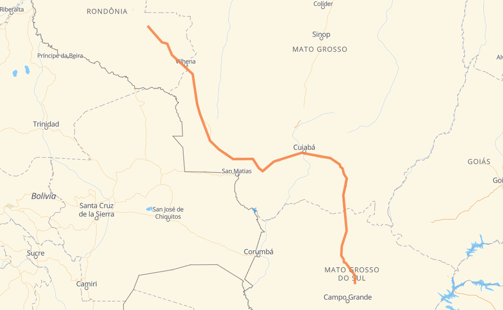
Distance between Bandeirantes and Cacoal
The distance from Bandeirantes to Cacoal is 1,004 miles by road including 74 miles on motorways. Road takes approximately 18 hours and 53 minutes and goes through São Gabriel do Oeste, Rio Verde de Mato Grosso, Coxim, Vila Goulart, Jaciara, Novo Mundo and Vilhena.
| Shortest distance by air | 752 mi ✈️ |
| Car route length | 1,003.5 mi 🚗 |
| Driving time | 18 h 53 min |
| Fuel amount | 34.1 gal |
| Fuel cost | 134.1 USD |
| Point | Distance | Time | Fuel | |
| Bandeirantes | 0 mi | 00 min | 0.0 gal | |
|
BR-163 42 mi, 47 min
|
||||
| São Gabriel do Oeste | 42 mi | 47 min | 1.3 gal | |
|
BR-163 41 mi, 45 min
|
||||
| Rio Verde de Mato Grosso | 82 mi | 1 h 32 min | 2.6 gal | |
|
BR-163 42 mi, 47 min
|
||||
| Coxim | 124 mi | 2 h 20 min | 3.8 gal | |
|
BR-163 128 mi, 2 h 14 min
|
||||
| Vila Goulart | 252 mi | 4 h 35 min | 8.3 gal | |
|
BR-163 66 mi, 1 h 15 min
|
||||
| Jaciara | 318 mi | 5 h 51 min | 10.4 gal | |
|
BR-163 88 mi, 1 h 37 min
|
||||
| Novo Mundo | 406 mi | 7 h 28 min | 13.6 gal | |
|
BR-070 BR-174 461 mi, 8 h 44 min
|
||||
| Vilhena | 867 mi | 16 h 13 min | 29.3 gal | |
|
BR-364 92 mi, 1 h 47 min
|
||||
| Pimenta Bueno | 959 mi | 18 h 01 min | 31.9 gal | |
|
BR-364 44 mi, 51 min
|
||||
| Cacoal | 1,004 mi | 18 h 52 min | 33.8 gal | |
Hotels of Cacoal
Frequently Asked Questions
How much does it cost to drive from Bandeirantes to Cacoal?
Fuel cost: 134.1 USD
This fuel cost is calculated as: (Route length 1,003.5 mi) / (Fuel consumption 29.4 mpg) * (Fuel price 3.93 USD / gal)
You can adjust fuel consumption and fuel price here.
How long is a car ride from Bandeirantes to Cacoal?
Driving time: 18 h 53 min
This time is calculated for driving at the maximum permitted speed, taking into account traffic rules restrictions.
- 55 mi with a maximum speed 62 mph = 52 min
- 498 mi with a maximum speed 56 mph = 8 h 54 min
- 447 mi with a maximum speed 50 mph = 9 h
- 1 mi with a maximum speed 37 mph = 1 min
- 1 mi with a maximum speed 31 mph = 1 min
- 1 mi with a maximum speed 25 mph = 3 min
The calculated driving time does not take into account intermediate stops and traffic jams.
How far is Bandeirantes to Cacoal by land?
The distance between Bandeirantes and Cacoal is 1,003.5 mi by road including 73.9 mi on motorways.
Precise satellite coordinates of highways were used for this calculation. The start and finish points are the centers of Bandeirantes and Cacoal respectively.
How far is Bandeirantes to Cacoal by plane?
The shortest distance (air line, as the crow flies) between Bandeirantes and Cacoal is 751.9 mi.
This distance is calculated using the Haversine formula as a great-circle distance between two points on the surface of a sphere. The start and finish points are the centers of Bandeirantes and Cacoal respectively. Actual distance between airports may be different.
How many hours is Bandeirantes from Cacoal by plane?
Boeing 737 airliner needs 1 h 30 min to cover the distance of 752 mi at a cruising speed of 497 mph.
Small plane "Cessna 172" needs 5 h 30 min to flight this distance at average speed of 136 mph.
This time is approximate and do not take into account takeoff and landing times, airport location and other real world factors.
How long is a helicopter ride from Bandeirantes to Cacoal?
Fast helicopter "Eurocopter AS350" or "Hughes OH-6 Cayuse" need 5 h 2 min to cover the distance of 752 mi at a cruising speed of 149 mph.
Popular "Robinson R44" needs 5 h 45 min to flight this distance at average speed of 130 mph.
This time is approximate and do not take into account takeoff and landing times, aerodrome location and other real world factors.
What city is halfway between Bandeirantes and Cacoal?
The halfway point between Bandeirantes and Cacoal is Sadia. It is located about 6 mi from the exact midpoint by road.
The distance from Sadia to Bandeirantes is 508 mi and driving will take about 9 h 31 min. The road between Sadia and Cacoal has length 496 mi and will take approximately 9 h 21 min.
The other cities located close to halfway point:
Where is Bandeirantes in relation to Cacoal?
Bandeirantes is located 752 mi south-east of Cacoal.
Bandeirantes has geographic coordinates: latitude -19.91805, longitude -54.36472.
Cacoal has geographic coordinates: latitude -11.4333, longitude -61.44205.
Which highway goes from Bandeirantes to Cacoal?
The route from Bandeirantes to Cacoal follows BR-163, BR-174, BR-364, BR-070.
Other minor sections pass along the road:
- BR-060: 17 mi
- MT-407: 10 mi