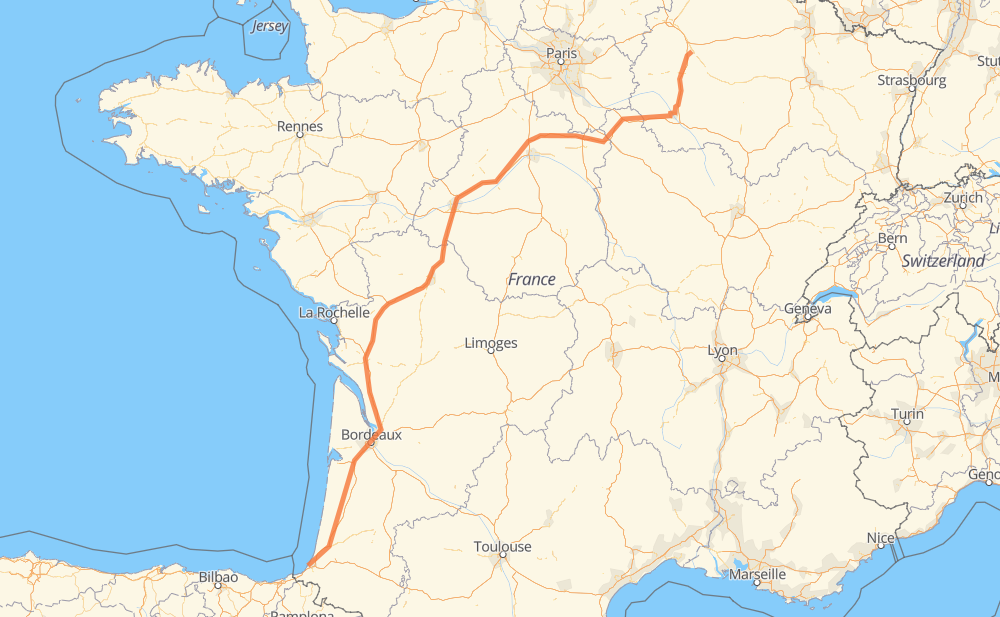
Distance between Biarritz and Châlons-en-Champagne

The distance from Biarritz to Châlons-en-Champagne is 582 miles by road including 550 miles on motorways. Road takes approximately 8 hours and 47 minutes and goes through Poitiers, Tours, Anglet, Bayonne, Tarnos, Le Souquet and Cestas.

There are tolls on the route.
Shortest distance by air 472 mi ✈️
Car route length 581.6 mi 🚗
Driving time 8 h 47 min
Fuel amount 19.8 gal
Fuel cost 77.2 USD
Click here to load the interactive map
Compare this route in other services:
City
Town
Village
Hamlet
Motorway
Primary
Secondary
Unclassified
Point Distance Time Fuel
Biarritz 0 mi 0:00 00 min 0.0 gal
2 mi, 03 min
Anglet 2 mi 0:03 03 min 0.1 gal
D 810 2 mi, 03 min
Bayonne 4 mi 0:06 06 min 0.1 gal
D 810 4 mi, 03 min
Tarnos 8 mi 0:10 10 min 0.2 gal
A 63 40 mi, 35 min
Le Souquet 48 mi 0:46 46 min 1.4 gal
A 63 58 mi, 51 min
Cestas 106 mi 1:37 1 h 37 min 3.5 gal
A 63 6 mi, 05 min
Gradignan 113 mi 1:43 1 h 43 min 3.8 gal
A 63 A 10 161 mi, 2 h 24 min
Poitiers 273 mi 4:07 4 h 07 min 9.2 gal
A 10 60 mi, 54 min
Tours 334 mi 5:02 5 h 02 min 11.2 gal
A 10 A 19 247 mi, 3 h 45 min
Châlons-en-Champagne 582 mi 8:47 8 h 47 min 19.7 gal
City
Town
Village
Hamlet
Motorway
Primary
Secondary
Unclassified
Point Distance Time Fuel
Biarritz 0 mi 0:00 00 min 0.0 gal
2 mi, 03 min
Anglet 2 mi 0:03 03 min 0.1 gal
D 810 2 mi, 03 min
Bayonne 4 mi 0:06 06 min 0.1 gal
D 810 4 mi, 03 min
Tarnos 8 mi 0:10 10 min 0.2 gal
A 63 6 mi, 04 min
Labenne 14 mi 0:15 15 min 0.4 gal
A 63 17 mi, 15 min
Magescq 31 mi 0:31 31 min 0.9 gal
A 63 17 mi, 14 min
Le Souquet 48 mi 0:46 46 min 1.4 gal
A 63 19 mi, 16 min
Labouheyre 67 mi 1:03 1 h 03 min 2.3 gal
A 63 7 mi, 05 min
Liposthey 74 mi 1:08 1 h 08 min 2.4 gal
A 63 5 mi, 04 min
Au Houdin 79 mi 1:13 1 h 13 min 2.6 gal
A 63 27 mi, 24 min
Cestas 106 mi 1:37 1 h 37 min 3.5 gal
A 63 6 mi, 05 min
Gradignan 113 mi 1:43 1 h 43 min 3.8 gal
A 63 4 mi, 03 min
Villenave-d'Ornon 116 mi 1:47 1 h 47 min 3.9 gal
A 630 3 mi, 03 min
Bègles 119 mi 1:50 1 h 50 min 4.0 gal
N 230 2 mi, 02 min
Floirac 122 mi 1:53 1 h 53 min 4.1 gal
N 230 3 mi, 03 min
Lormont 126 mi 1:56 1 h 56 min 4.2 gal
N 230 A 10 4 mi, 03 min
Ambarès-et-Lagrave 129 mi 2:00 2 h 00 min 4.4 gal
A 10 7 mi, 05 min
Saint-Antoine 135 mi 2:06 2 h 06 min 4.6 gal
A 10 9 mi, 07 min
Virsac 145 mi 2:13 2 h 13 min 4.6 gal
A 10 13 mi, 11 min
Pleine-Selve 157 mi 2:25 2 h 25 min 5.2 gal
A 10 16 mi, 13 min
Rançannes 173 mi 2:39 2 h 39 min 5.8 gal
A 10 12 mi, 10 min
Saintes 185 mi 2:49 2 h 49 min 6.0 gal
A 10 17 mi, 14 min
Chez Guerin 202 mi 3:04 3 h 04 min 6.7 gal
A 10 13 mi, 11 min
La Cavaterie 215 mi 3:16 3 h 16 min 7.0 gal
A 10 26 mi, 22 min
Romans 241 mi 3:38 3 h 38 min 8.2 gal
A 10 2 mi, 01 min
Soignon 243 mi 3:40 3 h 40 min 8.2 gal
A 10 14 mi, 12 min
Moulin de Pairé 257 mi 3:52 3 h 52 min 8.7 gal
A 10 3 mi, 02 min
Le Portail 260 mi 3:55 3 h 55 min 8.8 gal
A 10 14 mi, 12 min
Poitiers 273 mi 4:07 4 h 07 min 9.2 gal
A 10 4 mi, 03 min
Preuilly 278 mi 4:11 4 h 11 min 9.4 gal
A 10 2 mi, 02 min
Jaunay-Clan 281 mi 4:13 4 h 13 min 9.5 gal
A 10 3 mi, 02 min
Saint-Léger 283 mi 4:16 4 h 16 min 9.6 gal
A 10 3 mi, 02 min
La Ballonnière 286 mi 4:18 4 h 18 min 9.7 gal
A 10 2 mi, 01 min
Naintré 288 mi 4:20 4 h 20 min 9.8 gal
A 10 6 mi, 04 min
Châtellerault 294 mi 4:25 4 h 25 min 9.8 gal
A 10 7 mi, 06 min
Vellèches 301 mi 4:31 4 h 31 min 10.2 gal
A 10 3 mi, 02 min
Montigny 304 mi 4:34 4 h 34 min 10.3 gal
A 10 1 mi, 01 min
Sauvage 306 mi 4:35 4 h 35 min 10.4 gal
A 10 3 mi, 02 min
Maillé 309 mi 4:38 4 h 38 min 10.5 gal
A 10 1 mi, 00 min
La Gaudinière 310 mi 4:39 4 h 39 min 10.5 gal
A 10 2 mi, 01 min
La Peuvrie 312 mi 4:41 4 h 41 min 10.6 gal
A 10 2 mi, 02 min
La Gravière 315 mi 4:43 4 h 43 min 10.7 gal
A 10 4 mi, 03 min
La Saulaie 319 mi 4:47 4 h 47 min 10.7 gal
A 10 7 mi, 05 min
La Poitevinière 326 mi 4:53 4 h 53 min 11.0 gal
A 10 3 mi, 02 min
Joué-lès-Tours 329 mi 4:56 4 h 56 min 11.2 gal
A 10 1 mi, 00 min
La Baraudière 329 mi 4:56 4 h 56 min 11.2 gal
A 10 1 mi, 00 min
Les Touches 330 mi 4:57 4 h 57 min 11.2 gal
A 10 4 mi, 04 min
Tours 334 mi 5:01 5 h 01 min 11.2 gal
A 10 5 mi, 04 min
Parçay-Meslay 339 mi 5:06 5 h 06 min 11.5 gal
A 10 7 mi, 06 min
Neuillé-le-Lierre 346 mi 5:12 5 h 12 min 11.7 gal
A 10 14 mi, 12 min
Saint-Lubin-en-Vergonnois 360 mi 5:25 5 h 25 min 12.0 gal
A 10 9 mi, 08 min
Villebarou 370 mi 5:33 5 h 33 min 12.5 gal
A 10 6 mi, 05 min
Villerbon 376 mi 5:38 5 h 38 min 12.6 gal
A 10 11 mi, 09 min
Messas 386 mi 5:47 5 h 47 min 13.0 gal
A 10 21 mi, 18 min
Saran 408 mi 6:06 6 h 06 min 13.7 gal
A 10 A 19 19 mi, 16 min
La Brosse 426 mi 6:23 6 h 23 min 14.5 gal
A 19 6 mi, 04 min
Laas 431 mi 6:27 6 h 27 min 14.6 gal
A 19 13 mi, 11 min
Bordeaux-en-Gâtinais 445 mi 6:39 6 h 39 min 15.0 gal
A 19 10 mi, 08 min
Girolles 454 mi 6:48 6 h 48 min 15.4 gal
A 19 8 mi, 07 min
La Sambonnerie 462 mi 6:55 6 h 55 min 15.7 gal
A 19 9 mi, 07 min
Courtenay 471 mi 7:02 7 h 02 min 16.0 gal
A 19 5 mi, 04 min
Vernoy 476 mi 7:07 7 h 07 min 16.1 gal
A 19 7 mi, 06 min
Villeroy 483 mi 7:14 7 h 14 min 16.4 gal
A 19 4 mi, 03 min
Nailly 487 mi 7:17 7 h 17 min 16.5 gal
A 19 7 mi, 06 min
Soucy 494 mi 7:23 7 h 23 min 16.8 gal
A 5 7 mi, 06 min
Lailly 501 mi 7:29 7 h 29 min 16.9 gal
A 5 19 mi, 17 min
Fontvannes 521 mi 7:46 7 h 46 min 17.7 gal
A 5 D 660 9 mi, 08 min
La Chapelle-Saint-Luc 529 mi 7:55 7 h 55 min 18.0 gal
D 610 2 mi, 02 min
Lavau 532 mi 7:58 7 h 58 min 18.1 gal
D 610 D 677 6 mi, 06 min
Feuges 538 mi 8:05 8 h 05 min 18.3 gal
D 15 A 26 11 mi, 09 min
Torcy-le-Petit 548 mi 8:14 8 h 14 min 18.6 gal
A 26 34 mi, 31 min
Châlons-en-Champagne 582 mi 8:46 8 h 46 min 19.7 gal

Frequently Asked Questions

How much does it cost to drive from Biarritz to Châlons-en-Champagne?

Fuel cost: 77.2 USD

This fuel cost is calculated as: (Route length 581.6 mi) / (Fuel consumption 29.4 mpg) * (Fuel price 3.9 USD / gal)

You can adjust fuel consumption and fuel price here.

How long is a car ride from Biarritz to Châlons-en-Champagne?

Driving time: 8 h 47 min

This time is calculated for driving at the maximum permitted speed, taking into account traffic rules restrictions.

  • 529 mi with a maximum speed 68 mph = 7 h 46 min
  • 4 mi with a maximum speed 62 mph = 4 min
  • 10 mi with a maximum speed 56 mph = 10 min
  • 23 mi with a maximum speed 56 mph = 24 min
  • 10 mi with a maximum speed 50 mph = 11 min
  • 3 mi with a maximum speed 43 mph = 4 min
  • 3 mi with a maximum speed 31 mph = 5 min

The calculated driving time does not take into account intermediate stops and traffic jams.

How far is Biarritz to Châlons-en-Champagne by land?

The distance between Biarritz and Châlons-en-Champagne is 581.6 mi by road including 549.9 mi on motorways.

Precise satellite coordinates of highways were used for this calculation. The start and finish points are the centers of Biarritz and Châlons-en-Champagne respectively.

How far is Biarritz to Châlons-en-Champagne by plane?

The shortest distance (air line, as the crow flies) between Biarritz and Châlons-en-Champagne is 472.2 mi.

This distance is calculated using the Haversine formula as a great-circle distance between two points on the surface of a sphere. The start and finish points are the centers of Biarritz and Châlons-en-Champagne respectively. Actual distance between airports may be different.

How many hours is Biarritz from Châlons-en-Champagne by plane?

Boeing 737 airliner needs 57 min to cover the distance of 472 mi at a cruising speed of 497 mph.

Small plane "Cessna 172" needs 3 h 27 min to flight this distance at average speed of 136 mph.

This time is approximate and do not take into account takeoff and landing times, airport location and other real world factors.

How long is a helicopter ride from Biarritz to Châlons-en-Champagne?

Fast helicopter "Eurocopter AS350" or "Hughes OH-6 Cayuse" need 3 h 10 min to cover the distance of 472 mi at a cruising speed of 149 mph.

Popular "Robinson R44" needs 3 h 37 min to flight this distance at average speed of 130 mph.

This time is approximate and do not take into account takeoff and landing times, aerodrome location and other real world factors.

What city is halfway between Biarritz and Châlons-en-Champagne?

The halfway point between Biarritz and Châlons-en-Champagne is Naintré. It is located about 2 mi from the exact midpoint by road.

The distance from Naintré to Biarritz is 288 mi and driving will take about 4 h 20 min. The road between Naintré and Châlons-en-Champagne has length 293 mi and will take approximately 4 h 27 min.

The other cities located close to halfway point:

  • Châtellerault is in 294 mi from Biarritz and 288 mi from Châlons-en-Champagne
  • La Ballonnière is in 286 mi from Biarritz and 295 mi from Châlons-en-Champagne
  • Saint-Léger is in 283 mi from Biarritz and 298 mi from Châlons-en-Champagne

Where is Biarritz in relation to Châlons-en-Champagne?

Biarritz is located 472 mi south-west of Châlons-en-Champagne.

Biarritz has geographic coordinates: latitude 43.48159, longitude -1.55611.

Châlons-en-Champagne has geographic coordinates: latitude 48.95662, longitude 4.36289.

Which highway goes from Biarritz to Châlons-en-Champagne?

The route from Biarritz to Châlons-en-Champagne follows A 10, A 63, A 19.

Other minor sections pass along the road:

  • A 26: 36 mi
  • A 5: 31 mi
  • N 230: 7 mi
  • A 630: 5 mi
  • D 610: 5 mi
  • D 677: 4 mi
  • D 810: 3 mi
  • D 660: 3 mi
  • D 15: 2 mi
  • D 5: 2 mi
  • D 977: 2 mi
  • D 3: 1 mi
The distance between Biarritz and Châlons-en-Champagne is ranked 48,149th in the ranking popularity.
Have any questions? Contact us!