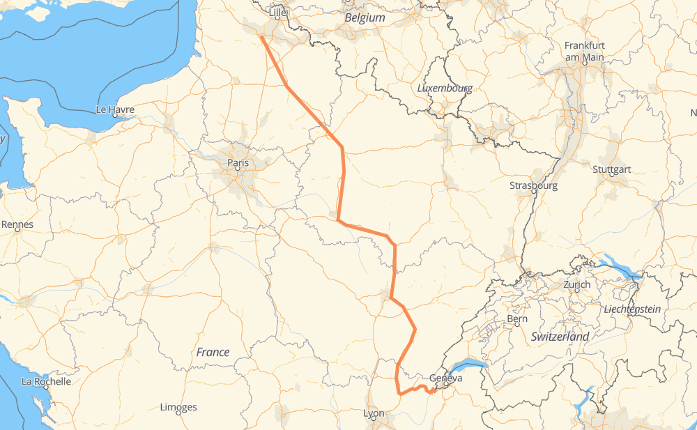
Distance between Bloux and Liévin

The distance from Bloux to Liévin is 442 miles by road including 419 miles on motorways. Road takes approximately 6 hours and 42 minutes and goes through Reims, Bellegarde-sur-Valserine, Chevigny-Saint-Sauveur, Avion and Lens.

There are tolls on the route.
Shortest distance by air 333 mi ✈️
Car route length 441.8 mi 🚗
Driving time 6 h 42 min
Fuel amount 15 gal
Fuel cost 59.1 USD
Click here to load the interactive map
Compare this route in other services:
City
Town
Village
Hamlet
Motorway
Primary
Secondary
Unclassified
Point Distance Time Fuel
Bloux 0 mi 0:00 00 min 0.0 gal
D 47 1 mi, 01 min
Dingy-en-Vuache 1 mi 0:01 01 min 0.0 gal
D 7 2 mi, 02 min
Vulbens 2 mi 0:04 04 min 0.1 gal
D 1206 9 mi, 12 min
Bellegarde-sur-Valserine 12 mi 0:17 17 min 0.4 gal
D 1206 A 39 135 mi, 2 h 00 min
Chevigny-Saint-Sauveur 147 mi 2:18 2 h 18 min 4.9 gal
A 31 A 26 181 mi, 2 h 41 min
Reims 329 mi 4:59 4 h 59 min 11.0 gal
A 4 A 26 110 mi, 1 h 38 min
Avion 438 mi 6:38 6 h 38 min 14.9 gal
N 17 1 mi, 01 min
Lens 439 mi 6:39 6 h 39 min 14.9 gal
D 58 2 mi, 03 min
Liévin 442 mi 6:42 6 h 42 min 15.0 gal
City
Town
Village
Hamlet
Motorway
Primary
Secondary
Unclassified
Point Distance Time Fuel
Bloux 0 mi 0:00 00 min 0.0 gal
D 47 1 mi, 01 min
Dingy-en-Vuache 1 mi 0:01 01 min 0.0 gal
D 7 2 mi, 02 min
Vulbens 2 mi 0:04 04 min 0.1 gal
D 1206 1 mi, 01 min
Chevrier 4 mi 0:05 05 min 0.1 gal
D 1206 4 mi, 04 min
Longeray 7 mi 0:10 10 min 0.2 gal
D 1206 1 mi, 01 min
Léaz 9 mi 0:12 12 min 0.3 gal
D 1206 1 mi, 01 min
Grésin 10 mi 0:14 14 min 0.3 gal
D 1206 2 mi, 02 min
Bellegarde-sur-Valserine 12 mi 0:17 17 min 0.4 gal
D 1206 A 40 4 mi, 05 min
Châtillon-en-Michaille 17 mi 0:22 22 min 0.5 gal
A 40 4 mi, 03 min
La Voute 21 mi 0:26 26 min 0.7 gal
A 40 3 mi, 02 min
Le Martinet 24 mi 0:28 28 min 0.8 gal
A 40 3 mi, 02 min
Les Neyrolles 27 mi 0:31 31 min 0.9 gal
A 40 4 mi, 03 min
Saint-Martin-du-Frêne 31 mi 0:35 35 min 1.0 gal
A 40 4 mi, 03 min
Ceignes 34 mi 0:38 38 min 1.1 gal
A 40 2 mi, 02 min
Chamagnat 37 mi 0:40 40 min 1.2 gal
A 40 7 mi, 06 min
Mas Pommier 44 mi 0:47 47 min 1.5 gal
A 40 2 mi, 01 min
Chiloup 46 mi 0:48 48 min 1.5 gal
A 40 3 mi, 02 min
Les Brovières 49 mi 0:51 51 min 1.6 gal
A 40 1 mi, 01 min
La Grande Vavrette 50 mi 0:52 52 min 1.7 gal
A 40 6 mi, 04 min
Gas Péroud 55 mi 0:57 57 min 1.9 gal
A 40 A 39 11 mi, 09 min
La Bottière 66 mi 1:06 1 h 06 min 2.2 gal
A 39 4 mi, 03 min
Le Chêne 70 mi 1:10 1 h 10 min 2.4 gal
A 39 1 mi, 01 min
Leschaux 72 mi 1:11 1 h 11 min 2.4 gal
A 39 4 mi, 03 min
Le Bourgneuf 76 mi 1:14 1 h 14 min 2.5 gal
A 39 4 mi, 03 min
Moulin du Miroir 79 mi 1:17 1 h 17 min 2.6 gal
A 39 4 mi, 03 min
Moulin de la Broye 83 mi 1:21 1 h 21 min 2.8 gal
A 39 2 mi, 01 min
Les Pendants 85 mi 1:23 1 h 23 min 2.9 gal
A 39 2 mi, 01 min
Les Tillets 87 mi 1:24 1 h 24 min 2.9 gal
A 39 2 mi, 01 min
La Chauniat 89 mi 1:26 1 h 26 min 3.0 gal
A 39 6 mi, 05 min
Bard 95 mi 1:31 1 h 31 min 3.2 gal
A 39 8 mi, 06 min
La Charme 103 mi 1:38 1 h 38 min 3.4 gal
A 39 7 mi, 06 min
Villers-les-Bois 110 mi 1:44 1 h 44 min 3.7 gal
A 39 4 mi, 04 min
Séligney 114 mi 1:48 1 h 48 min 3.8 gal
A 39 7 mi, 06 min
Gevry 122 mi 1:55 1 h 55 min 4.1 gal
A 39 8 mi, 06 min
Ferme de la Grande Rosotte 130 mi 2:02 2 h 02 min 4.4 gal
A 39 7 mi, 06 min
Premières 137 mi 2:08 2 h 08 min 4.6 gal
A 39 5 mi, 04 min
Magny-sur-Tille 142 mi 2:13 2 h 13 min 4.8 gal
A 39 A 31 5 mi, 04 min
Chevigny-Saint-Sauveur 147 mi 2:17 2 h 17 min 4.9 gal
A 31 6 mi, 05 min
Brognon 153 mi 2:23 2 h 23 min 5.1 gal
A 31 12 mi, 10 min
Orville 166 mi 2:34 2 h 34 min 5.6 gal
A 31 14 mi, 12 min
Villiers-lès-Aprey 180 mi 2:46 2 h 46 min 6.0 gal
A 31 14 mi, 12 min
Marac 194 mi 2:58 2 h 58 min 6.5 gal
A 5 18 mi, 15 min
Essey-les-Ponts 212 mi 3:14 3 h 14 min 7.2 gal
A 5 3 mi, 03 min
Juvancourt 215 mi 3:17 3 h 17 min 7.3 gal
A 5 21 mi, 18 min
Magnant 236 mi 3:36 3 h 36 min 8.0 gal
A 5 6 mi, 04 min
Poligny, Aube 242 mi 3:41 3 h 41 min 8.1 gal
A 5 5 mi, 04 min
Fresnoy-le-Château 247 mi 3:45 3 h 45 min 8.4 gal
A 5 A 26 6 mi, 05 min
Thennelières 253 mi 3:50 3 h 50 min 8.6 gal
A 26 17 mi, 15 min
Torcy-le-Petit 270 mi 4:05 4 h 05 min 9.2 gal
A 26 46 mi, 40 min
Les Petites-Loges 316 mi 4:46 4 h 46 min 10.6 gal
A 4 5 mi, 04 min
Puisieulx 321 mi 4:51 4 h 51 min 10.8 gal
A 4 4 mi, 03 min
Reims 324 mi 4:54 4 h 54 min 11.0 gal
A 4 3 mi, 02 min
Bezannes 327 mi 4:57 4 h 57 min 11.1 gal
A 4 2 mi, 01 min
Ormes 329 mi 4:59 4 h 59 min 11.2 gal
A 26 1 mi, 00 min
Thillois 331 mi 5:00 5 h 00 min 11.2 gal
A26 1 mi, 01 min
Champigny 332 mi 5:01 5 h 01 min 11.2 gal
A 26 2 mi, 01 min
Reims 334 mi 5:03 5 h 03 min 11.3 gal
A 26 13 mi, 11 min
Amifontaine 347 mi 5:14 5 h 14 min 11.7 gal
A 26 5 mi, 04 min
Résidence des Garennes 352 mi 5:18 5 h 18 min 12.0 gal
A 26 4 mi, 03 min
Eppes 356 mi 5:22 5 h 22 min 12.0 gal
A 26 53 mi, 46 min
Marcoing 409 mi 6:09 6 h 09 min 13.9 gal
A 26 4 mi, 03 min
Bourlon 413 mi 6:12 6 h 12 min 14.0 gal
A 26 4 mi, 03 min
Marquion 416 mi 6:15 6 h 15 min 14.1 gal
A 26 4 mi, 03 min
Dury 420 mi 6:18 6 h 18 min 14.2 gal
A 26 4 mi, 03 min
Hamblain-les-Prés 424 mi 6:22 6 h 22 min 14.4 gal
A 26 2 mi, 02 min
Plouvain 426 mi 6:24 6 h 24 min 14.5 gal
A 26 7 mi, 07 min
Thélus 434 mi 6:31 6 h 31 min 14.7 gal
N 17 4 mi, 05 min
Avion 438 mi 6:36 6 h 36 min 14.9 gal
N 17 1 mi, 01 min
Lens 439 mi 6:38 6 h 38 min 14.9 gal
D 58 1 mi, 00 min
Éleu-dit-Leauwette 440 mi 6:38 6 h 38 min 14.9 gal
D 58 2 mi, 02 min
Liévin 442 mi 6:41 6 h 41 min 15.0 gal

Frequently Asked Questions

How much does it cost to drive from Bloux to Liévin?

Fuel cost: 59.1 USD

This fuel cost is calculated as: (Route length 441.8 mi) / (Fuel consumption 29.4 mpg) * (Fuel price 3.93 USD / gal)

You can adjust fuel consumption and fuel price here.

How long is a car ride from Bloux to Liévin?

Driving time: 6 h 42 min

This time is calculated for driving at the maximum permitted speed, taking into account traffic rules restrictions.

  • 413 mi with a maximum speed 68 mph = 6 h 3 min
  • 2 mi with a maximum speed 56 mph = 2 min
  • 7 mi with a maximum speed 56 mph = 8 min
  • 11 mi with a maximum speed 50 mph = 13 min
  • 2 mi with a maximum speed 43 mph = 3 min
  • 6 mi with a maximum speed 31 mph = 11 min

The calculated driving time does not take into account intermediate stops and traffic jams.

How far is Bloux to Liévin by land?

The distance between Bloux and Liévin is 441.8 mi by road including 418.8 mi on motorways.

Precise satellite coordinates of highways were used for this calculation. The start and finish points are the centers of Bloux and Liévin respectively.

How far is Bloux to Liévin by plane?

The shortest distance (air line, as the crow flies) between Bloux and Liévin is 333.1 mi.

This distance is calculated using the Haversine formula as a great-circle distance between two points on the surface of a sphere. The start and finish points are the centers of Bloux and Liévin respectively. Actual distance between airports may be different.

How many hours is Bloux from Liévin by plane?

Boeing 737 airliner needs 40 min to cover the distance of 333 mi at a cruising speed of 497 mph.

Small plane "Cessna 172" needs 2 h 26 min to flight this distance at average speed of 136 mph.

This time is approximate and do not take into account takeoff and landing times, airport location and other real world factors.

How long is a helicopter ride from Bloux to Liévin?

Fast helicopter "Eurocopter AS350" or "Hughes OH-6 Cayuse" need 2 h 14 min to cover the distance of 333 mi at a cruising speed of 149 mph.

Popular "Robinson R44" needs 2 h 33 min to flight this distance at average speed of 130 mph.

This time is approximate and do not take into account takeoff and landing times, aerodrome location and other real world factors.

What city is halfway between Bloux and Liévin?

The halfway point between Bloux and Liévin is Juvancourt. It is located about 6 mi from the exact midpoint by road.

The distance from Juvancourt to Bloux is 215 mi and driving will take about 3 h 17 min. The road between Juvancourt and Liévin has length 227 mi and will take approximately 3 h 25 min.

The other cities located close to halfway point:

  • Essey-les-Ponts is in 212 mi from Bloux and 231 mi from Liévin
  • Magnant is in 236 mi from Bloux and 206 mi from Liévin
  • Poligny, Aube is in 242 mi from Bloux and 200 mi from Liévin

Where is Bloux in relation to Liévin?

Bloux is located 333 mi south-east of Liévin.

Bloux has geographic coordinates: latitude 46.09307, longitude 5.96495.

Liévin has geographic coordinates: latitude 50.4245, longitude 2.7738.

Which highway goes from Bloux to Liévin?

The route from Bloux to Liévin follows A 26, A 39.

Other minor sections pass along the road:

  • A 5: 57 mi
  • A 31: 47 mi
  • A 40: 43 mi
  • A 4: 21 mi
  • D 1206: 10 mi
  • N 17: 6 mi
  • D 58: 2 mi
  • D 101f: 1 mi
  • D 47: 1 mi
  • D 7: 1 mi
Have any questions? Contact us!