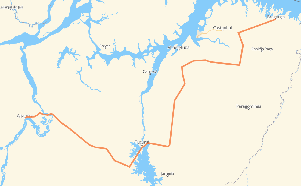
Distance between Bragança and Altamira
The distance from Bragança to Altamira is 628 miles by road. Road takes approximately 12 hours and 55 minutes and goes through Tailândia, Tracuateua, Bairro Marilandia and Vila Residencial Belo Monte.
| Shortest distance by air | 405 mi ✈️ |
| Car route length | 628.2 mi 🚗 |
| Driving time | 12 h 55 min |
| Fuel amount | 21.4 gal |
| Fuel cost | 84 USD |
| Point | Distance | Time | Fuel | |
| -1.05740, -46.76354 | 0 mi | 00 min | 0.0 gal | |
|
BR-308 11 mi, 20 min
|
||||
| Tracuateua | 11 mi | 20 min | 0.5 gal | |
|
BR-308 6 mi, 10 min
|
||||
| Vila dos Neves | 16 mi | 31 min | 0.7 gal | |
|
PA-448 19 mi, 35 min
|
||||
| Manoel dos Santos | 35 mi | 1 h 07 min | 1.4 gal | |
|
BR-308 BR-316 17 mi, 22 min
|
||||
| Quatro Bocas | 52 mi | 1 h 29 min | 1.9 gal | |
|
BR-316 14 mi, 19 min
|
||||
| Bairro Marilandia | 66 mi | 1 h 49 min | 2.5 gal | |
|
BR-010 26 mi, 35 min
|
||||
| Km 14 | 92 mi | 2 h 24 min | 3.2 gal | |
|
BR-010 21 mi, 25 min
|
||||
| Nossa Senhora de Fátima | 112 mi | 2 h 49 min | 3.9 gal | |
|
BR-010 PA-252 19 mi, 22 min
|
||||
| Balsa do Capim | 132 mi | 3 h 11 min | 4.5 gal | |
|
PA-252 164 mi, 3 h 15 min
|
||||
| Tailândia | 296 mi | 6 h 27 min | 9.5 gal | |
|
PA-150 BR-230 293 mi, 5 h 45 min
|
||||
| Vila Residencial Belo Monte | 589 mi | 12 h 13 min | 20.2 gal | |
|
BR-230 39 mi, 42 min
|
||||
| -3.20407, -52.20996 | 628 mi | 12 h 55 min | 21.6 gal | |
Hotels of Altamira
Frequently Asked Questions
How much does it cost to drive from Bragança to Altamira?
Fuel cost: 84 USD
This fuel cost is calculated as: (Route length 628.2 mi) / (Fuel consumption 29.4 mpg) * (Fuel price 3.93 USD / gal)
You can adjust fuel consumption and fuel price here.
How long is a car ride from Bragança to Altamira?
Driving time: 12 h 55 min
This time is calculated for driving at the maximum permitted speed, taking into account traffic rules restrictions.
- 216 mi with a maximum speed 56 mph = 3 h 50 min
- 366 mi with a maximum speed 50 mph = 7 h 21 min
- 14 mi with a maximum speed 37 mph = 23 min
- 31 mi with a maximum speed 25 mph = 1 h 14 min
- 1 mi with a maximum speed 19 mph = 4 min
The calculated driving time does not take into account intermediate stops and traffic jams.
How far is Bragança to Altamira by land?
The distance between Bragança and Altamira is 628.2 mi by road.
Precise satellite coordinates of highways were used for this calculation. The start and finish points are the centers of Bragança and Altamira respectively.
How far is Bragança to Altamira by plane?
The shortest distance (air line, as the crow flies) between Bragança and Altamira is 404.5 mi.
This distance is calculated using the Haversine formula as a great-circle distance between two points on the surface of a sphere. The start and finish points are the centers of Bragança and Altamira respectively. Actual distance between airports may be different.
How many hours is Bragança from Altamira by plane?
Boeing 737 airliner needs 48 min to cover the distance of 405 mi at a cruising speed of 497 mph.
Small plane "Cessna 172" needs 2 h 57 min to flight this distance at average speed of 136 mph.
This time is approximate and do not take into account takeoff and landing times, airport location and other real world factors.
How long is a helicopter ride from Bragança to Altamira?
Fast helicopter "Eurocopter AS350" or "Hughes OH-6 Cayuse" need 2 h 42 min to cover the distance of 405 mi at a cruising speed of 149 mph.
Popular "Robinson R44" needs 3 h 6 min to flight this distance at average speed of 130 mph.
This time is approximate and do not take into account takeoff and landing times, aerodrome location and other real world factors.
What city is halfway between Bragança and Altamira?
The halfway point between Bragança and Altamira is Nossa Senhora Aparecida. It is located about 11 mi from the exact midpoint by road.
The distance from Nossa Senhora Aparecida to Bragança is 324 mi and driving will take about 7 h 1 min. The road between Nossa Senhora Aparecida and Altamira has length 304 mi and will take approximately 5 h 54 min.
The other cities located close to halfway point:
Where is Bragança in relation to Altamira?
Bragança is located 405 mi north-east of Altamira.
Bragança has geographic coordinates: latitude -1.0574, longitude -46.76354.
Altamira has geographic coordinates: latitude -3.20407, longitude -52.20996.
Which highway goes from Bragança to Altamira?
The route from Bragança to Altamira follows BR-230, PA-475, PA-150, PA-252.
Other minor sections pass along the road:
- BR-010: 51 mi
- PA-263: 45 mi
- BR-422: 37 mi
- BR-316: 29 mi
- BR-308: 16 mi
- PA-448: 11 mi
- PA-140: 7 mi
- PA-253: 6 mi