Distance between California and Ejido Nicolás Bravo
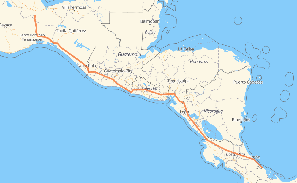
The distance from California to Ejido Nicolás Bravo is 1,302 miles by road including 1 mile on motorways. Road takes approximately 26 hours and 41 minutes and goes through Rivas, Jinotepe, Choluteca, San Lorenzo, Santa Rosa de Lima, San Miguel and Cojutepeque.
You can adjust fuel consumption and fuel price here.
Toll roads cost:
19 MXN
How long is a car ride from California to Ejido Nicolás Bravo?
Driving time:
26 h 41 min
This time is calculated for driving at the maximum permitted speed, taking into account traffic rules restrictions.
222 mi with a maximum speed 56 mph = 3 h 58 min
155 mi with a maximum speed 56 mph = 2 h 46 min
752 mi with a maximum speed 50 mph = 15 h 7 min
51 mi with a maximum speed 43 mph = 1 h 10 min
107 mi with a maximum speed 37 mph = 2 h 52 min
1 mi with a maximum speed 31 mph = 2 min
4 mi with a maximum speed 28 mph = 8 min
13 mi with a maximum speed 25 mph = 32 min
1 mi with a maximum speed 16 mph = 1 min
The calculated driving time does not take into account intermediate stops and traffic jams.
How far is California to Ejido Nicolás Bravo by land?
The distance between California and Ejido Nicolás Bravo is 1,301.8 mi by road including 0.6 mi on motorways.
Precise satellite coordinates of highways were used for this calculation. The start and finish points are the centers of California and Ejido Nicolás Bravo respectively.
How far is California to Ejido Nicolás Bravo by plane?
The shortest distance (air line, as the crow flies) between California and Ejido Nicolás Bravo is 1,009.7 mi.
This distance is calculated using the Haversine formula as a great-circle distance between two points on the surface of a sphere. The start and finish points are the centers of California and Ejido Nicolás Bravo respectively. Actual distance between airports may be different.
How many hours is California from Ejido Nicolás Bravo by plane?
Boeing 737 airliner needs 2 h 1 min to cover the distance of 1,010 mi at a cruising speed of 497 mph.
Small plane "Cessna 172" needs 7 h 23 min to flight this distance at average speed of 136 mph.
This time is approximate and do not take into account takeoff and landing times, airport location and other real world factors.
How long is a helicopter ride from California to Ejido Nicolás Bravo?
Fast helicopter "Eurocopter AS350" or "Hughes OH-6 Cayuse" need 6 h 46 min to cover the distance of 1,010 mi at a cruising speed of 149 mph.
Popular "Robinson R44" needs 7 h 44 min to flight this distance at average speed of 130 mph.
This time is approximate and do not take into account takeoff and landing times, aerodrome location and other real world factors.
What city is halfway between California and Ejido Nicolás Bravo?
The halfway point between California and Ejido Nicolás Bravo is Río Frío. It is located about 10 mi from the exact midpoint by road.
The distance from Río Frío to California is 641 mi and driving will take about 13 h 39 min. The road between Río Frío and Ejido Nicolás Bravo has length 661 mi and will take approximately 13 h 2 min.
The other cities located close to halfway point:
San Lorenzo is in 639 mi from California and 663 mi from Ejido Nicolás Bravo
Santo Domingo is in 665 mi from California and 637 mi from Ejido Nicolás Bravo
Cojutepeque is in 672 mi from California and 631 mi from Ejido Nicolás Bravo
Where is California in relation to Ejido Nicolás Bravo?
California is located 1,010 mi south-east of Ejido Nicolás Bravo.
California has geographic coordinates: latitude 9.54031, longitude -82.58778.
Ejido Nicolás Bravo has geographic coordinates: latitude 17.69282, longitude -95.08009.
Which highway goes from California to Ejido Nicolás Bravo?
The route from California to Ejido Nicolás Bravo follows MEX 200, 4, CA-1, CA-2, NIC-2, MEX 185, CA-2 OR, 32.