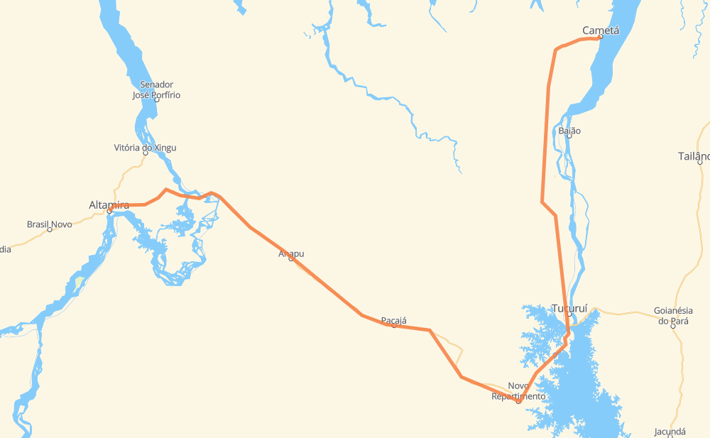
Distance between Cametá and Altamira
The distance from Cametá to Altamira is 374 miles by road. Road takes approximately 8 hours and 28 minutes and goes through Tucuruí, Vila Residencial Belo Monte, Uxi, Vila Costeira, Nova América, Anilzinho and Angelim.
| Shortest distance by air | 199 mi ✈️ |
| Car route length | 374.1 mi 🚗 |
| Driving time | 8 h 28 min |
| Fuel amount | 12.7 gal |
| Fuel cost | 50 USD |
| Point | Distance | Time | Fuel | |
| -2.24295, -49.49789 | 0 mi | 00 min | 0.0 gal | |
|
PA-156 18 mi, 21 min
|
||||
| Uxi | 18 mi | 21 min | 1.1 gal | |
|
PA-156 38 mi, 1 h 13 min
|
||||
| Vila Costeira | 56 mi | 1 h 34 min | 1.2 gal | |
|
BR-422 58 mi, 1 h 49 min
|
||||
| Tucuruí | 114 mi | 3 h 24 min | 3.8 gal | |
|
BR-422 BR-230 114 mi, 2 h 18 min
|
||||
| Aratau | 229 mi | 5 h 43 min | 8.0 gal | |
|
BR-230 45 mi, 50 min
|
||||
| Nazaré | 274 mi | 6 h 34 min | 9.6 gal | |
|
BR-230 24 mi, 26 min
|
||||
| Sucupira | 298 mi | 7 h 01 min | 10.6 gal | |
|
BR-230 22 mi, 25 min
|
||||
| Vila Isabel | 320 mi | 7 h 26 min | 11.2 gal | |
|
BR-230 11 mi, 12 min
|
||||
| Belo Monte do Pontal | 330 mi | 7 h 39 min | 11.7 gal | |
|
BR-230 5 mi, 06 min
|
||||
| Vila Residencial Belo Monte | 335 mi | 7 h 46 min | 11.9 gal | |
|
BR-230 4 mi, 04 min
|
||||
| Santo Antônio | 339 mi | 7 h 50 min | 12.1 gal | |
|
BR-230 35 mi, 37 min
|
||||
| -3.20407, -52.20996 | 374 mi | 8 h 28 min | 13.3 gal | |
Hotels of Altamira
Frequently Asked Questions
How much does it cost to drive from Cametá to Altamira?
Fuel cost: 50 USD
This fuel cost is calculated as: (Route length 374.1 mi) / (Fuel consumption 29.4 mpg) * (Fuel price 3.93 USD / gal)
You can adjust fuel consumption and fuel price here.
How long is a car ride from Cametá to Altamira?
Driving time: 8 h 28 min
This time is calculated for driving at the maximum permitted speed, taking into account traffic rules restrictions.
- 172 mi with a maximum speed 56 mph = 3 h 4 min
- 91 mi with a maximum speed 50 mph = 1 h 50 min
- 110 mi with a maximum speed 31 mph = 3 h 32 min
The calculated driving time does not take into account intermediate stops and traffic jams.
How far is Cametá to Altamira by land?
The distance between Cametá and Altamira is 374.1 mi by road.
Precise satellite coordinates of highways were used for this calculation. The start and finish points are the centers of Cametá and Altamira respectively.
How far is Cametá to Altamira by plane?
The shortest distance (air line, as the crow flies) between Cametá and Altamira is 198.8 mi.
This distance is calculated using the Haversine formula as a great-circle distance between two points on the surface of a sphere. The start and finish points are the centers of Cametá and Altamira respectively. Actual distance between airports may be different.
How many hours is Cametá from Altamira by plane?
Boeing 737 airliner needs 24 min to cover the distance of 199 mi at a cruising speed of 497 mph.
Small plane "Cessna 172" needs 1 h 27 min to flight this distance at average speed of 136 mph.
This time is approximate and do not take into account takeoff and landing times, airport location and other real world factors.
How long is a helicopter ride from Cametá to Altamira?
Fast helicopter "Eurocopter AS350" or "Hughes OH-6 Cayuse" need 1 h 20 min to cover the distance of 199 mi at a cruising speed of 149 mph.
Popular "Robinson R44" needs 1 h 31 min to flight this distance at average speed of 130 mph.
This time is approximate and do not take into account takeoff and landing times, aerodrome location and other real world factors.
What city is halfway between Cametá and Altamira?
Where is Cametá in relation to Altamira?
Cametá is located 199 mi north-east of Altamira.
Cametá has geographic coordinates: latitude -2.24295, longitude -49.49789.
Altamira has geographic coordinates: latitude -3.20407, longitude -52.20996.
Which highway goes from Cametá to Altamira?
The route from Cametá to Altamira follows BR-230, BR-422.
Other minor sections pass along the road:
- PA-156: 17 mi