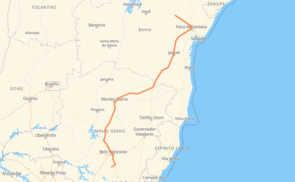
Distance between Capim Grosso and Entre Rios de Minas
The distance from Capim Grosso to Entre Rios de Minas is 972 miles by road including 130 miles on motorways. Road takes approximately 18 hours and 33 minutes and goes through Ribeirão das Neves, Entrocamento do Cem, Distrito Industrial dos Imborés, Nossa Senhora Aparecida, Felícia, Salinas and Francisco Sá.
| Shortest distance by air | 696 mi ✈️ |
| Car route length | 971.8 mi 🚗 |
| Driving time | 18 h 33 min |
| Fuel amount | 33.1 gal |
| Fuel cost | 129.9 USD |
| Point | Distance | Time | Fuel | |
| Capim Grosso | 0 mi | 00 min | 0.0 gal | |
|
BR-324 BR-116 197 mi, 3 h 30 min
|
||||
| Entrocamento do Cem | 197 mi | 3 h 30 min | 6.6 gal | |
|
BR-116 151 mi, 3 h 01 min
|
||||
| Distrito Industrial dos Imborés | 348 mi | 6 h 31 min | 11.8 gal | |
|
BR-116 2 mi, 02 min
|
||||
| Nossa Senhora Aparecida | 350 mi | 6 h 34 min | 11.9 gal | |
|
BR-116 5 mi, 07 min
|
||||
| Felícia | 355 mi | 6 h 41 min | 12.1 gal | |
|
BR-116 165 mi, 3 h 10 min
|
||||
| Salinas | 520 mi | 9 h 52 min | 17.3 gal | |
|
BR-251 85 mi, 1 h 40 min
|
||||
| Francisco Sá | 605 mi | 11 h 32 min | 20.0 gal | |
|
BR-251 42 mi, 47 min
|
||||
| Santo Amaro | 647 mi | 12 h 20 min | 22.0 gal | |
|
CMG-135 BR-135 240 mi, 4 h 23 min
|
||||
| Ribeirão das Neves | 888 mi | 16 h 44 min | 30.1 gal | |
|
BR-040 88 mi, 1 h 49 min
|
||||
| Entre Rios de Minas | 976 mi | 18 h 33 min | 32.9 gal | |
Frequently Asked Questions
How much does it cost to drive from Capim Grosso to Entre Rios de Minas?
Fuel cost: 129.9 USD
This fuel cost is calculated as: (Route length 971.8 mi) / (Fuel consumption 29.4 mpg) * (Fuel price 3.93 USD / gal)
You can adjust fuel consumption and fuel price here.
How long is a car ride from Capim Grosso to Entre Rios de Minas?
Driving time: 18 h 33 min
This time is calculated for driving at the maximum permitted speed, taking into account traffic rules restrictions.
- 85 mi with a maximum speed 68 mph = 1 h 15 min
- 16 mi with a maximum speed 62 mph = 15 min
- 461 mi with a maximum speed 56 mph = 8 h 13 min
- 4 mi with a maximum speed 56 mph = 3 min
- 339 mi with a maximum speed 50 mph = 6 h 49 min
- 16 mi with a maximum speed 43 mph = 21 min
- 47 mi with a maximum speed 37 mph = 1 h 16 min
- 2 mi with a maximum speed 31 mph = 5 min
- 5 mi with a maximum speed 25 mph = 11 min
The calculated driving time does not take into account intermediate stops and traffic jams.
How far is Capim Grosso to Entre Rios de Minas by land?
The distance between Capim Grosso and Entre Rios de Minas is 971.8 mi by road including 129.9 mi on motorways.
Precise satellite coordinates of highways were used for this calculation. The start and finish points are the centers of Capim Grosso and Entre Rios de Minas respectively.
How far is Capim Grosso to Entre Rios de Minas by plane?
The shortest distance (air line, as the crow flies) between Capim Grosso and Entre Rios de Minas is 695.9 mi.
This distance is calculated using the Haversine formula as a great-circle distance between two points on the surface of a sphere. The start and finish points are the centers of Capim Grosso and Entre Rios de Minas respectively. Actual distance between airports may be different.
How many hours is Capim Grosso from Entre Rios de Minas by plane?
Boeing 737 airliner needs 1 h 24 min to cover the distance of 696 mi at a cruising speed of 497 mph.
Small plane "Cessna 172" needs 5 h 5 min to flight this distance at average speed of 136 mph.
This time is approximate and do not take into account takeoff and landing times, airport location and other real world factors.
How long is a helicopter ride from Capim Grosso to Entre Rios de Minas?
Fast helicopter "Eurocopter AS350" or "Hughes OH-6 Cayuse" need 4 h 40 min to cover the distance of 696 mi at a cruising speed of 149 mph.
Popular "Robinson R44" needs 5 h 20 min to flight this distance at average speed of 130 mph.
This time is approximate and do not take into account takeoff and landing times, aerodrome location and other real world factors.
What city is halfway between Capim Grosso and Entre Rios de Minas?
The halfway point between Capim Grosso and Entre Rios de Minas is Saco. It is located about 14 mi from the exact midpoint by road.
The distance from Saco to Capim Grosso is 472 mi and driving will take about 8 h 54 min. The road between Saco and Entre Rios de Minas has length 500 mi and will take approximately 9 h 38 min.
The other cities located close to halfway point:
Where is Capim Grosso in relation to Entre Rios de Minas?
Capim Grosso is located 696 mi north-east of Entre Rios de Minas.
Capim Grosso has geographic coordinates: latitude -11.37932, longitude -40.01121.
Entre Rios de Minas has geographic coordinates: latitude -20.67083, longitude -44.06556.
Which highway goes from Capim Grosso to Entre Rios de Minas?
The route from Capim Grosso to Entre Rios de Minas follows BR-116, BR-135, BR-251, BR-040, BR-324.
Other minor sections pass along the road:
- CMG-135: 29 mi
- BA-262: 22 mi
- BR-383: 14 mi
- BR-356: 12 mi
- BR-122: 11 mi
- LMG-653: 7 mi
- CMG-251: 6 mi
- CMG-122: 6 mi
- MGC-122: 6 mi
- MGC-251: 6 mi
- MGC-383: 6 mi
- BR-030: 2 mi
- BR-381: 1 mi
- BR-262: 1 mi