Distance between Carlos Salinas de Gortari (La Estancia) and Iguala
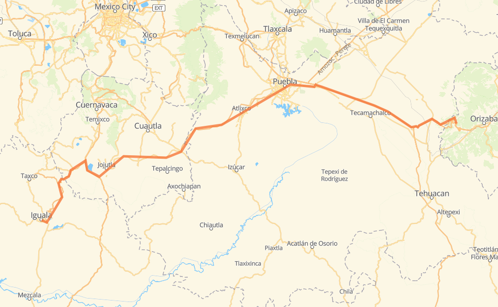
The distance from Carlos Salinas de Gortari (La Estancia) to Iguala is 214 miles by road including 155 miles on motorways. Road takes approximately 3 hours and 53 minutes and goes through Puebla, Cuacnopalan, Palmarito Tochapan, Acatzingo de Hidalgo, Rinconada Amozoc 21, Casa Blanca and Puente de Ixtla.
| Shortest distance by air | 153 mi ✈️ |
| Car route length | 214.4 mi 🚗 |
| Driving time | 3 h 53 min |
| Fuel amount | 7.3 gal |
| Fuel cost | 28.6 USD |
| Toll roads cost | 266 + ? MXN |
| Point | Distance | Time | Fuel | |
| Carlos Salinas de Gortari (La Estancia) | 0 mi | 00 min | 0.0 gal | |
|
MEX 150D 9 mi, 10 min
|
||||
| San José Cuyachapa | 9 mi | 10 min | 0.1 gal | |
|
MEX 150D 20 mi, 23 min
|
||||
| Cuacnopalan | 29 mi | 34 min | 0.8 gal | |
|
MEX 150D 8 mi, 09 min
|
||||
| Palmarito Tochapan | 37 mi | 43 min | 1.2 gal | |
|
MEX 150D 9 mi, 09 min
|
||||
| Acatzingo de Hidalgo | 45 mi | 53 min | 1.4 gal | |
|
MEX 150D 21 mi, 19 min
|
||||
| Rinconada Amozoc 21 | 66 mi | 1 h 12 min | 2.2 gal | |
|
MEX 150 5 mi, 06 min
|
||||
| Casa Blanca | 71 mi | 1 h 18 min | 2.4 gal | |
|
6 mi, 07 min
|
||||
| Puebla | 76 mi | 1 h 26 min | 2.5 gal | |
|
PUE 438D 99 mi, 1 h 41 min
|
||||
| Puente de Ixtla | 176 mi | 3 h 08 min | 5.9 gal | |
|
MEX 091D 38 mi, 45 min
|
||||
| Iguala | 214 mi | 3 h 53 min | 7.2 gal | |
Hotels of Iguala
Frequently Asked Questions
How many toll booths are there from Carlos Salinas de Gortari (La Estancia) to Iguala?
There are 6 toll booths between Carlos Salinas de Gortari (La Estancia) and Iguala: Iguala, Amozoc, Esperanza 27, Vía Atlixcayotl, Siglo XXI and Tlaltizapan.
How much does the toll booths cost from Carlos Salinas de Gortari (La Estancia) to Iguala?
Toll roads cost: Esperanza 27 (140 MXN) + Amozoc (38 MXN) + Vía Atlixcayotl (?) + Siglo XXI (?) + Tlaltizapan (?) + Iguala (88 MXN) = 266 + ? MXN
How much does it cost to drive from Carlos Salinas de Gortari (La Estancia) to Iguala?
Fuel cost: 28.6 USD
This fuel cost is calculated as: (Route length 214.4 mi) / (Fuel consumption 29.4 mpg) * (Fuel price 3.93 USD / gal)
You can adjust fuel consumption and fuel price here.
Toll roads cost: 266 + ? MXN
How long is a car ride from Carlos Salinas de Gortari (La Estancia) to Iguala?
Driving time: 3 h 53 min
This time is calculated for driving at the maximum permitted speed, taking into account traffic rules restrictions.
- 48 mi with a maximum speed 68 mph = 42 min
- 39 mi with a maximum speed 62 mph = 37 min
- 10 mi with a maximum speed 56 mph = 10 min
- 15 mi with a maximum speed 56 mph = 15 min
- 86 mi with a maximum speed 50 mph = 1 h 43 min
- 14 mi with a maximum speed 43 mph = 19 min
- 1 mi with a maximum speed 31 mph = 1 min
- 1 mi with a maximum speed 25 mph = 1 min
The calculated driving time does not take into account intermediate stops and traffic jams.
How far is Carlos Salinas de Gortari (La Estancia) to Iguala by land?
The distance between Carlos Salinas de Gortari (La Estancia) and Iguala is 214.4 mi by road including 154.7 mi on motorways.
Precise satellite coordinates of highways were used for this calculation. The start and finish points are the centers of Carlos Salinas de Gortari (La Estancia) and Iguala respectively.
How far is Carlos Salinas de Gortari (La Estancia) to Iguala by plane?
The shortest distance (air line, as the crow flies) between Carlos Salinas de Gortari (La Estancia) and Iguala is 153.5 mi.
This distance is calculated using the Haversine formula as a great-circle distance between two points on the surface of a sphere. The start and finish points are the centers of Carlos Salinas de Gortari (La Estancia) and Iguala respectively. Actual distance between airports may be different.
How many hours is Carlos Salinas de Gortari (La Estancia) from Iguala by plane?
Boeing 737 airliner needs 18 min to cover the distance of 153 mi at a cruising speed of 497 mph.
Small plane "Cessna 172" needs 1 h 7 min to flight this distance at average speed of 136 mph.
This time is approximate and do not take into account takeoff and landing times, airport location and other real world factors.
How long is a helicopter ride from Carlos Salinas de Gortari (La Estancia) to Iguala?
Fast helicopter "Eurocopter AS350" or "Hughes OH-6 Cayuse" need 1 h 1 min to cover the distance of 153 mi at a cruising speed of 149 mph.
Popular "Robinson R44" needs 1 h 10 min to flight this distance at average speed of 130 mph.
This time is approximate and do not take into account takeoff and landing times, aerodrome location and other real world factors.
What city is halfway between Carlos Salinas de Gortari (La Estancia) and Iguala?
The halfway point between Carlos Salinas de Gortari (La Estancia) and Iguala is San Juan Tejupa. It is located about 4 mi from the exact midpoint by road.
The distance from San Juan Tejupa to Carlos Salinas de Gortari (La Estancia) is 111 mi and driving will take about 2 h 4 min. The road between San Juan Tejupa and Iguala has length 103 mi and will take approximately 1 h 49 min.
The other cities located close to halfway point:
Where is Carlos Salinas de Gortari (La Estancia) in relation to Iguala?
Carlos Salinas de Gortari (La Estancia) is located 153 mi east of Iguala.
Carlos Salinas de Gortari (La Estancia) has geographic coordinates: latitude 18.84718, longitude -97.25552.
Iguala has geographic coordinates: latitude 18.3438, longitude -99.53722.
Which highway goes from Carlos Salinas de Gortari (La Estancia) to Iguala?
The route from Carlos Salinas de Gortari (La Estancia) to Iguala follows MEX 150D.
Other minor sections pass along the road:
- PUE 438D: 34 mi
- MEX 091D: 27 mi
- MEX 190D: 12 mi
- MEX 91D: 12 mi
- MEX 95D: 7 mi
- MEX 150: 4 mi
- MEX 95: 2 mi
- MEX 129: 1 mi