Distance between Ceará and Barreira
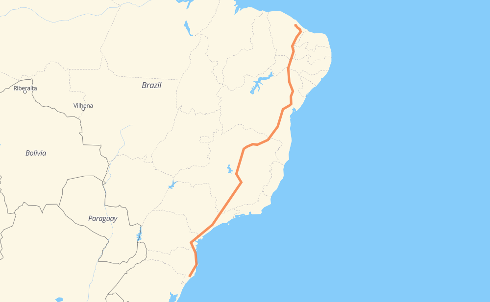
The distance from Ceará to Barreira is 2,336 miles by road including 973 miles on motorways. Road takes approximately 42 hours and 16 minutes and goes through Piraquara, Taboão da Serra, Barueri, Atibaia, Betim, Contagem and Ribeirão das Neves.
| Shortest distance by air | 1,827 mi ✈️ |
| Car route length | 2,336.4 mi 🚗 |
| Driving time | 42 h 16 min |
| Fuel amount | 79.5 gal |
| Fuel cost | 312.3 USD |
| Point | Distance | Time | Fuel | |
| -28.68762, -49.35324 | 0 mi | 00 min | 0.0 gal | |
|
SC-445 7 mi, 07 min
|
||||
| Jardim América | 7 mi | 07 min | 0.4 gal | |
|
SC-445 BR-101 4 mi, 04 min
|
||||
| Esperança | 11 mi | 11 min | 0.5 gal | |
|
BR-101 4 mi, 03 min
|
||||
| Esplanada | 14 mi | 14 min | 0.7 gal | |
|
BR-101 283 mi, 4 h 42 min
|
||||
| Piraquara | 297 mi | 4 h 57 min | 10.1 gal | |
|
BR-116 237 mi, 4 h 05 min
|
||||
| Taboão da Serra | 534 mi | 9 h 03 min | 18.3 gal | |
|
SP-230 SP-021 11 mi, 11 min
|
||||
| Barueri | 545 mi | 9 h 14 min | 18.7 gal | |
|
SP-021 SP-354 46 mi, 52 min
|
||||
| Atibaia | 591 mi | 10 h 06 min | 20.0 gal | |
|
SP-065 BR-381 305 mi, 4 h 43 min
|
||||
| Betim | 897 mi | 14 h 50 min | 30.6 gal | |
|
BR-381 10 mi, 10 min
|
||||
| Contagem | 906 mi | 15 h 00 min | 30.9 gal | |
|
BR-040 14 mi, 17 min
|
||||
| Ribeirão das Neves | 920 mi | 15 h 17 min | 31.4 gal | |
|
BR-040 BR-116 1,430 mi, 26 h 58 min
|
||||
| -4.28834, -38.64109 | 2,351 mi | 42 h 16 min | 80.2 gal | |
Frequently Asked Questions
How much does it cost to drive from Ceará to Barreira?
Fuel cost: 312.3 USD
This fuel cost is calculated as: (Route length 2,336.4 mi) / (Fuel consumption 29.4 mpg) * (Fuel price 3.93 USD / gal)
You can adjust fuel consumption and fuel price here.
How long is a car ride from Ceará to Barreira?
Driving time: 42 h 16 min
This time is calculated for driving at the maximum permitted speed, taking into account traffic rules restrictions.
- 570 mi with a maximum speed 68 mph = 8 h 23 min
- 219 mi with a maximum speed 62 mph = 3 h 31 min
- 784 mi with a maximum speed 56 mph = 13 h 59 min
- 41 mi with a maximum speed 56 mph = 44 min
- 626 mi with a maximum speed 50 mph = 12 h 35 min
- 14 mi with a maximum speed 43 mph = 18 min
- 85 mi with a maximum speed 37 mph = 2 h 16 min
- 1 mi with a maximum speed 31 mph = 2 min
- 10 mi with a maximum speed 25 mph = 23 min
The calculated driving time does not take into account intermediate stops and traffic jams.
How far is Ceará to Barreira by land?
The distance between Ceará and Barreira is 2,336.4 mi by road including 973.1 mi on motorways.
Precise satellite coordinates of highways were used for this calculation. The start and finish points are the centers of Ceará and Barreira respectively.
How far is Ceará to Barreira by plane?
The shortest distance (air line, as the crow flies) between Ceará and Barreira is 1,826.8 mi.
This distance is calculated using the Haversine formula as a great-circle distance between two points on the surface of a sphere. The start and finish points are the centers of Ceará and Barreira respectively. Actual distance between airports may be different.
How many hours is Ceará from Barreira by plane?
Boeing 737 airliner needs 3 h 40 min to cover the distance of 1,827 mi at a cruising speed of 497 mph.
Small plane "Cessna 172" needs 13 h 21 min to flight this distance at average speed of 136 mph.
This time is approximate and do not take into account takeoff and landing times, airport location and other real world factors.
How long is a helicopter ride from Ceará to Barreira?
Fast helicopter "Eurocopter AS350" or "Hughes OH-6 Cayuse" need 12 h 15 min to cover the distance of 1,827 mi at a cruising speed of 149 mph.
Popular "Robinson R44" needs 14 h to flight this distance at average speed of 130 mph.
This time is approximate and do not take into account takeoff and landing times, aerodrome location and other real world factors.
What city is halfway between Ceará and Barreira?
The halfway point between Ceará and Barreira is Balaio. It is located about 4 mi from the exact midpoint by road.
The distance from Balaio to Ceará is 1,172 mi and driving will take about 19 h 54 min. The road between Balaio and Barreira has length 1,164 mi and will take approximately 22 h 21 min.
The other cities located close to halfway point:
Where is Ceará in relation to Barreira?
Ceará is located 1,827 mi south-west of Barreira.
Ceará has geographic coordinates: latitude -28.68762, longitude -49.35324.
Barreira has geographic coordinates: latitude -4.28834, longitude -38.64109.
Which highway goes from Ceará to Barreira?
The route from Ceará to Barreira follows BR-116, BR-381, BR-135, BR-101, BR-251, SP-230, BR-040.
Other minor sections pass along the road:
- BR-376: 46 mi
- BR-478: 30 mi
- CMG-135: 29 mi
- SP-354: 24 mi
- SP-010: 22 mi
- BA-262: 22 mi
- SP-021: 14 mi
- BR-122: 12 mi
- CE-354: 10 mi
- BR-050: 9 mi
- SP-330: 9 mi
- SP-065: 8 mi
- BR-230: 8 mi
- SC-445: 7 mi
- LMG-653: 7 mi
- CE-284: 7 mi
- MGC-251: 6 mi
- MGC-122: 6 mi
- CMG-122: 6 mi
- CMG-251: 6 mi
- BR-277: 6 mi
- JAR-354: 6 mi
- BR-262: 4 mi
- BR-030: 2 mi
- BR-494: 1 mi