Distance between Ceibas and Entre Ríos
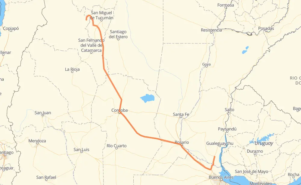
The distance from Ceibas to Entre Ríos is 847 miles by road including 380 miles on motorways. Road takes approximately 14 hours and 15 minutes and goes through Zárate, Rosario, Córdoba, Funes, Leones, Colonia Caroya and Jesús María.
| Shortest distance by air | 631 mi ✈️ |
| Car route length | 846.9 mi 🚗 |
| Driving time | 14 h 15 min |
| Fuel amount | 28.8 gal |
| Fuel cost | 113.2 USD |
| Point | Distance | Time | Fuel | |
| Ceibas | 0 mi | 00 min | 0.0 gal | |
|
RN12 42 mi, 45 min
|
||||
| Zárate | 42 mi | 45 min | 1.1 gal | |
|
RN12 RN9 139 mi, 2 h 05 min
|
||||
| Rosario | 181 mi | 2 h 50 min | 6.0 gal | |
|
RNA008 RN9 9 mi, 08 min
|
||||
| Funes | 190 mi | 2 h 59 min | 6.4 gal | |
|
RN9 90 mi, 1 h 19 min
|
||||
| Leones | 280 mi | 4 h 19 min | 9.4 gal | |
|
RN9 144 mi, 2 h 09 min
|
||||
| Córdoba | 425 mi | 6 h 28 min | 14.0 gal | |
|
RN9 26 mi, 29 min
|
||||
| Colonia Caroya | 451 mi | 6 h 58 min | 15.1 gal | |
|
RN9 7 mi, 08 min
|
||||
| Jesús María | 459 mi | 7 h 06 min | 15.6 gal | |
|
RN9 RN60 48 mi, 52 min
|
||||
| Deán Funes | 506 mi | 7 h 59 min | 17.0 gal | |
|
RN60 RN157 341 mi, 6 h 16 min
|
||||
| Entre Ríos | 847 mi | 14 h 15 min | 28.7 gal | |
Frequently Asked Questions
How much does it cost to drive from Ceibas to Entre Ríos?
Fuel cost: 113.2 USD
This fuel cost is calculated as: (Route length 846.9 mi) / (Fuel consumption 29.4 mpg) * (Fuel price 3.93 USD / gal)
You can adjust fuel consumption and fuel price here.
How long is a car ride from Ceibas to Entre Ríos?
Driving time: 14 h 15 min
This time is calculated for driving at the maximum permitted speed, taking into account traffic rules restrictions.
- 372 mi with a maximum speed 68 mph = 5 h 27 min
- 6 mi with a maximum speed 62 mph = 6 min
- 385 mi with a maximum speed 56 mph = 6 h 52 min
- 6 mi with a maximum speed 56 mph = 6 min
- 63 mi with a maximum speed 50 mph = 1 h 16 min
- 9 mi with a maximum speed 37 mph = 15 min
- 4 mi with a maximum speed 31 mph = 7 min
- 1 mi with a maximum speed 25 mph = 3 min
The calculated driving time does not take into account intermediate stops and traffic jams.
How far is Ceibas to Entre Ríos by land?
The distance between Ceibas and Entre Ríos is 846.9 mi by road including 379.7 mi on motorways.
Precise satellite coordinates of highways were used for this calculation. The start and finish points are the centers of Ceibas and Entre Ríos respectively.
How far is Ceibas to Entre Ríos by plane?
The shortest distance (air line, as the crow flies) between Ceibas and Entre Ríos is 631.3 mi.
This distance is calculated using the Haversine formula as a great-circle distance between two points on the surface of a sphere. The start and finish points are the centers of Ceibas and Entre Ríos respectively. Actual distance between airports may be different.
How many hours is Ceibas from Entre Ríos by plane?
Boeing 737 airliner needs 1 h 16 min to cover the distance of 631 mi at a cruising speed of 497 mph.
Small plane "Cessna 172" needs 4 h 37 min to flight this distance at average speed of 136 mph.
This time is approximate and do not take into account takeoff and landing times, airport location and other real world factors.
How long is a helicopter ride from Ceibas to Entre Ríos?
Fast helicopter "Eurocopter AS350" or "Hughes OH-6 Cayuse" need 4 h 14 min to cover the distance of 631 mi at a cruising speed of 149 mph.
Popular "Robinson R44" needs 4 h 50 min to flight this distance at average speed of 130 mph.
This time is approximate and do not take into account takeoff and landing times, aerodrome location and other real world factors.
What city is halfway between Ceibas and Entre Ríos?
The halfway point between Ceibas and Entre Ríos is Córdoba. It is located about 1 mi from the exact midpoint by road.
The distance from Córdoba to Ceibas is 425 mi and driving will take about 6 h 28 min. The road between Córdoba and Entre Ríos has length 422 mi and will take approximately 7 h 46 min.
The other cities located close to halfway point:
Where is Ceibas in relation to Entre Ríos?
Ceibas is located 631 mi south-east of Entre Ríos.
Ceibas has geographic coordinates: latitude -33.49912, longitude -58.79778.
Entre Ríos has geographic coordinates: latitude -26.83585, longitude -66.03533.
Which highway goes from Ceibas to Entre Ríos?
The route from Ceibas to Entre Ríos follows RN9, RN157, RN60, RP307.
Other minor sections pass along the road:
- RN12: 49 mi
- RP325: 11 mi
- RN2V9: 9 mi
- RNA019: 7 mi
- RP337: 6 mi
- RP17: 6 mi
- RNA008: 6 mi
- RN40: 6 mi
- RN38: 4 mi
- RN14: 1 mi