Distance between Centralina and Caldas
The distance from Centralina to Caldas is 371 miles by road including 157 miles on motorways. Road takes approximately 6 hours and 21 minutes and goes through Poços de Caldas, Prata, Planura, Cohab Pedro de Felício, Jardim Nova Aliança and Cravinhos.
| Shortest distance by air | 294 mi ✈️ |
| Car route length | 371 mi 🚗 |
| Driving time | 6 h 21 min |
| Fuel amount | 12.6 gal |
| Fuel cost | 49.6 USD |
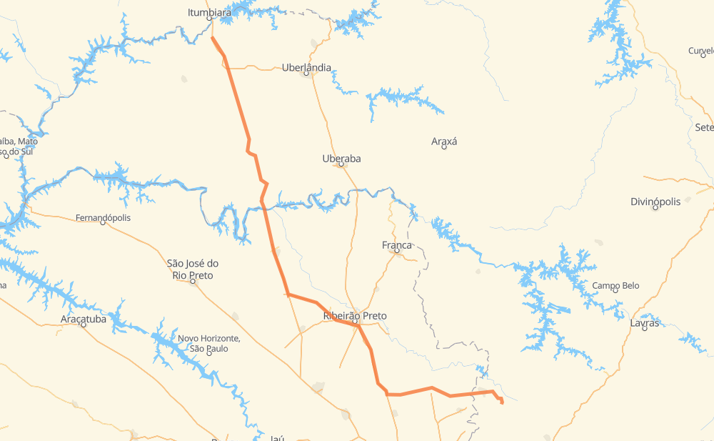
| Point | Distance | Time | Fuel | |
| Centralina | 0 mi | 00 min | 0.0 gal | |
|
BR-153 54 mi, 54 min
|
||||
| Prata | 54 mi | 54 min | 1.7 gal | |
|
BR-153 52 mi, 55 min
|
||||
| Pirajuba | 105 mi | 1 h 49 min | 3.5 gal | |
|
BR-455 19 mi, 20 min
|
||||
| Planura | 124 mi | 2 h 10 min | 4.1 gal | |
|
BR-364 SP-326 75 mi, 1 h 12 min
|
||||
| Cohab Pedro de Felício | 198 mi | 3 h 22 min | 6.7 gal | |
|
SP-322 30 mi, 29 min
|
||||
| Jardim Nova Aliança | 229 mi | 3 h 52 min | 7.8 gal | |
|
SP-322 12 mi, 13 min
|
||||
| Cravinhos | 241 mi | 4 h 05 min | 8.0 gal | |
|
SP-330 BR-267 96 mi, 1 h 37 min
|
||||
| Porto da Cascata | 337 mi | 5 h 43 min | 11.3 gal | |
|
BR-267 MG-877 16 mi, 18 min
|
||||
| Poços de Caldas | 354 mi | 6 h 01 min | 11.9 gal | |
|
MG-877 BR-459 17 mi, 19 min
|
||||
| Caldas | 371 mi | 6 h 21 min | 12.5 gal | |
Hotels of Caldas
Frequently Asked Questions
How much does it cost to drive from Centralina to Caldas?
Fuel cost: 49.6 USD
This fuel cost is calculated as: (Route length 371 mi) / (Fuel consumption 29.4 mpg) * (Fuel price 3.93 USD / gal)
You can adjust fuel consumption and fuel price here.
How long is a car ride from Centralina to Caldas?
Driving time: 6 h 21 min
This time is calculated for driving at the maximum permitted speed, taking into account traffic rules restrictions.
- 121 mi with a maximum speed 68 mph = 1 h 46 min
- 22 mi with a maximum speed 62 mph = 21 min
- 181 mi with a maximum speed 56 mph = 3 h 13 min
- 6 mi with a maximum speed 56 mph = 6 min
- 34 mi with a maximum speed 50 mph = 40 min
- 3 mi with a maximum speed 43 mph = 4 min
- 1 mi with a maximum speed 37 mph = 2 min
- 2 mi with a maximum speed 25 mph = 5 min
The calculated driving time does not take into account intermediate stops and traffic jams.
How far is Centralina to Caldas by land?
The distance between Centralina and Caldas is 371 mi by road including 156.6 mi on motorways.
Precise satellite coordinates of highways were used for this calculation. The start and finish points are the centers of Centralina and Caldas respectively.
How far is Centralina to Caldas by plane?
The shortest distance (air line, as the crow flies) between Centralina and Caldas is 293.9 mi.
This distance is calculated using the Haversine formula as a great-circle distance between two points on the surface of a sphere. The start and finish points are the centers of Centralina and Caldas respectively. Actual distance between airports may be different.
How many hours is Centralina from Caldas by plane?
Boeing 737 airliner needs 35 min to cover the distance of 294 mi at a cruising speed of 497 mph.
Small plane "Cessna 172" needs 2 h 9 min to flight this distance at average speed of 136 mph.
This time is approximate and do not take into account takeoff and landing times, airport location and other real world factors.
How long is a helicopter ride from Centralina to Caldas?
Fast helicopter "Eurocopter AS350" or "Hughes OH-6 Cayuse" need 1 h 58 min to cover the distance of 294 mi at a cruising speed of 149 mph.
Popular "Robinson R44" needs 2 h 15 min to flight this distance at average speed of 130 mph.
This time is approximate and do not take into account takeoff and landing times, aerodrome location and other real world factors.
What city is halfway between Centralina and Caldas?
The halfway point between Centralina and Caldas is Cohab Pedro de Felício. It is located about 13 mi from the exact midpoint by road.
The distance from Cohab Pedro de Felício to Centralina is 198 mi and driving will take about 3 h 22 min. The road between Cohab Pedro de Felício and Caldas has length 173 mi and will take approximately 2 h 59 min.
The other cities located close to halfway point:
Where is Centralina in relation to Caldas?
Centralina is located 294 mi north-west of Caldas.
Centralina has geographic coordinates: latitude -18.58434, longitude -49.19547.
Caldas has geographic coordinates: latitude -21.92361, longitude -46.38611.
Which highway goes from Centralina to Caldas?
The route from Centralina to Caldas follows BR-153.
Other minor sections pass along the road:
- BR-267: 60 mi
- SP-215: 57 mi
- SP-326: 55 mi
- SP-322: 50 mi
- SP-330: 47 mi
- BR-050: 47 mi
- BR-364: 29 mi
- BR-455: 19 mi
- MG-877: 16 mi
- LMG-810: 15 mi
- BR-369: 13 mi
- BR-459: 12 mi
- BR-262: 8 mi
- SP-333: 6 mi
- MGC-455: 2 mi
- SPA 307/330: 2 mi
- SP-344: 1 mi
- AMG-1520: 1 mi