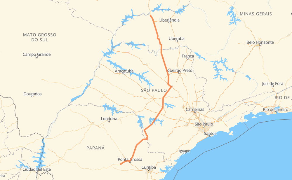
Distance between Centralina and Imbituva
The distance from Centralina to Imbituva is 591 miles by road including 129 miles on motorways. Road takes approximately 10 hours and 32 minutes and goes through Prata, Planura, Jardim Salto Grande I, Jardim Ouro Branco, Itaporanga, Bairro dos Lajes and Bairro do Rola-Burro.
| Shortest distance by air | 468 mi ✈️ |
| Car route length | 590.9 mi 🚗 |
| Driving time | 10 h 32 min |
| Fuel amount | 20.1 gal |
| Fuel cost | 79 USD |
| Point | Distance | Time | Fuel | |
| Centralina | 0 mi | 00 min | 0.0 gal | |
|
BR-153 54 mi, 54 min
|
||||
| Prata | 54 mi | 54 min | 1.7 gal | |
|
BR-153 70 mi, 1 h 16 min
|
||||
| Planura | 124 mi | 2 h 10 min | 4.1 gal | |
|
BR-364 SP-326 124 mi, 2 h 00 min
|
||||
| Jardim Salto Grande I | 248 mi | 4 h 10 min | 8.4 gal | |
|
SPI 274/310 SP-255 146 mi, 2 h 39 min
|
||||
| Jardim Ouro Branco | 394 mi | 6 h 49 min | 13.4 gal | |
|
SP-255 22 mi, 24 min
|
||||
| Itaporanga | 415 mi | 7 h 14 min | 13.8 gal | |
|
SP-255 12 mi, 13 min
|
||||
| Bairro do Rola-Burro | 427 mi | 7 h 28 min | 14.5 gal | |
|
SP-281 11 mi, 12 min
|
||||
| Bairro da Serrinha | 437 mi | 7 h 41 min | 14.6 gal | |
|
SP-281 15 mi, 17 min
|
||||
| Jardim Regina | 452 mi | 7 h 59 min | 15.3 gal | |
|
SP-258 PR-239 15 mi, 17 min
|
||||
| Centro | 467 mi | 8 h 16 min | 15.7 gal | |
|
PR-151 124 mi, 2 h 16 min
|
||||
| -25.22854, -50.59886 | 591 mi | 10 h 32 min | 20.1 gal | |
Frequently Asked Questions
How much does it cost to drive from Centralina to Imbituva?
Fuel cost: 79 USD
This fuel cost is calculated as: (Route length 590.9 mi) / (Fuel consumption 29.4 mpg) * (Fuel price 3.93 USD / gal)
You can adjust fuel consumption and fuel price here.
How long is a car ride from Centralina to Imbituva?
Driving time: 10 h 32 min
This time is calculated for driving at the maximum permitted speed, taking into account traffic rules restrictions.
- 80 mi with a maximum speed 68 mph = 1 h 10 min
- 46 mi with a maximum speed 62 mph = 44 min
- 375 mi with a maximum speed 56 mph = 6 h 41 min
- 81 mi with a maximum speed 50 mph = 1 h 38 min
- 4 mi with a maximum speed 37 mph = 6 min
- 4 mi with a maximum speed 25 mph = 11 min
The calculated driving time does not take into account intermediate stops and traffic jams.
How far is Centralina to Imbituva by land?
The distance between Centralina and Imbituva is 590.9 mi by road including 129.2 mi on motorways.
Precise satellite coordinates of highways were used for this calculation. The start and finish points are the centers of Centralina and Imbituva respectively.
How far is Centralina to Imbituva by plane?
The shortest distance (air line, as the crow flies) between Centralina and Imbituva is 467.9 mi.
This distance is calculated using the Haversine formula as a great-circle distance between two points on the surface of a sphere. The start and finish points are the centers of Centralina and Imbituva respectively. Actual distance between airports may be different.
How many hours is Centralina from Imbituva by plane?
Boeing 737 airliner needs 56 min to cover the distance of 468 mi at a cruising speed of 497 mph.
Small plane "Cessna 172" needs 3 h 25 min to flight this distance at average speed of 136 mph.
This time is approximate and do not take into account takeoff and landing times, airport location and other real world factors.
How long is a helicopter ride from Centralina to Imbituva?
Fast helicopter "Eurocopter AS350" or "Hughes OH-6 Cayuse" need 3 h 8 min to cover the distance of 468 mi at a cruising speed of 149 mph.
Popular "Robinson R44" needs 3 h 35 min to flight this distance at average speed of 130 mph.
This time is approximate and do not take into account takeoff and landing times, aerodrome location and other real world factors.
What city is halfway between Centralina and Imbituva?
The halfway point between Centralina and Imbituva is Jardim Salto Grande I. It is located about 48 mi from the exact midpoint by road.
The distance from Jardim Salto Grande I to Centralina is 248 mi and driving will take about 4 h 10 min. The road between Jardim Salto Grande I and Imbituva has length 343 mi and will take approximately 6 h 22 min.
The other cities located close to halfway point:
Where is Centralina in relation to Imbituva?
Centralina is located 468 mi north of Imbituva.
Centralina has geographic coordinates: latitude -18.58434, longitude -49.19547.
Imbituva has geographic coordinates: latitude -25.22854, longitude -50.59886.
Which highway goes from Centralina to Imbituva?
The route from Centralina to Imbituva follows SP-255, SP-326, PR-151, BR-153, BR-364.
Other minor sections pass along the road:
- BR-272: 43 mi
- SP-281: 34 mi
- BR-373: 24 mi
- BR-455: 19 mi
- LMG-810: 15 mi
- SP-310: 11 mi
- BR-262: 8 mi
- BR-267: 7 mi
- PR-239: 7 mi
- BR-376: 7 mi
- PRC-373: 5 mi
- BR-369: 4 mi
- PR 151: 2 mi
- MGC-455: 2 mi
- SP-304: 1 mi
- SPI 274/310: 1 mi