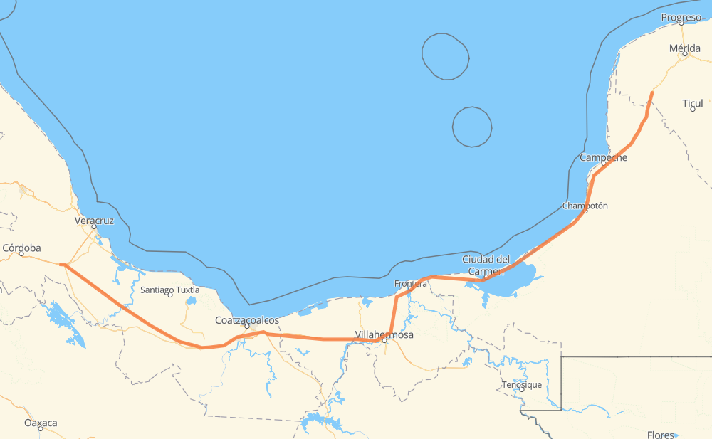
Distance between Cerro Alto and Sahcabá
The distance from Cerro Alto to Sahcabá is 567 miles by road including 239 miles on motorways. Road takes approximately 10 hours and 10 minutes and goes through Heroica Cárdenas, Frontera, Champotón, Hecelchakán, Calkini and Maxcanú.
| Shortest distance by air | 444 mi ✈️ |
| Car route length | 567.3 mi 🚗 |
| Driving time | 10 h 10 min |
| Fuel amount | 19.3 gal |
| Fuel cost | 75.9 USD |
| Toll roads cost | 560 + ? MXN |
| Point | Distance | Time | Fuel | |
| Cerro Alto | 0 mi | 00 min | 0.0 gal | |
|
MEX 150D MEX 145D 142 mi, 2 h 20 min
|
||||
| San Pedro Mártir | 142 mi | 2 h 20 min | 4.7 gal | |
|
MEX 145D MEX 180D 17 mi, 18 min
|
||||
| Ixhuatlán del Sureste | 160 mi | 2 h 38 min | 5.3 gal | |
|
MEX 180D 68 mi, 1 h 11 min
|
||||
| Heroica Cárdenas | 228 mi | 3 h 50 min | 7.4 gal | |
|
MEX 180 86 mi, 1 h 33 min
|
||||
| Frontera | 314 mi | 5 h 23 min | 10.3 gal | |
|
MEX 180 30 mi, 36 min
|
||||
| Atasta | 344 mi | 6 h 00 min | 11.0 gal | |
|
MEX 180 117 mi, 2 h 14 min
|
||||
| Champotón | 462 mi | 8 h 14 min | 15.5 gal | |
|
MEX 180 73 mi, 1 h 16 min
|
||||
| Hecelchakán | 535 mi | 9 h 31 min | 18.1 gal | |
|
MEX 180 22 mi, 24 min
|
||||
| Calkini | 556 mi | 9 h 56 min | 18.6 gal | |
|
MEX 180 11 mi, 13 min
|
||||
| Sahcabá | 567 mi | 10 h 10 min | 19.3 gal | |
Frequently Asked Questions
How many toll booths are there from Cerro Alto to Sahcabá?
There are 8 toll booths between Cerro Alto and Sahcabá: Cosamaloapan, Acayucan, Antonio Dovali, Sánchez Magallanes, Villahermosa Nacajuca, Zacatal, Unidad and Seybaplaya.
How much does the toll booths cost from Cerro Alto to Sahcabá?
Toll roads cost: Cosamaloapan (229 MXN) + Acayucan (?) + Antonio Dovali (20 MXN) + Sánchez Magallanes (82 MXN) + Villahermosa Nacajuca (62 MXN) + Zacatal (90 MXN) + Unidad (?) + Seybaplaya (77 MXN) = 560 + ? MXN
How much does it cost to drive from Cerro Alto to Sahcabá?
Fuel cost: 75.9 USD
This fuel cost is calculated as: (Route length 567.3 mi) / (Fuel consumption 29.4 mpg) * (Fuel price 3.93 USD / gal)
You can adjust fuel consumption and fuel price here.
Toll roads cost: 560 + ? MXN
How long is a car ride from Cerro Alto to Sahcabá?
Driving time: 10 h 10 min
This time is calculated for driving at the maximum permitted speed, taking into account traffic rules restrictions.
- 27 mi with a maximum speed 68 mph = 23 min
- 187 mi with a maximum speed 62 mph = 3 h
- 97 mi with a maximum speed 56 mph = 1 h 43 min
- 59 mi with a maximum speed 56 mph = 1 h 3 min
- 198 mi with a maximum speed 50 mph = 3 h 58 min
- 1 mi with a maximum speed 31 mph = 1 min
The calculated driving time does not take into account intermediate stops and traffic jams.
How far is Cerro Alto to Sahcabá by land?
The distance between Cerro Alto and Sahcabá is 567.3 mi by road including 238.6 mi on motorways.
Precise satellite coordinates of highways were used for this calculation. The start and finish points are the centers of Cerro Alto and Sahcabá respectively.
How far is Cerro Alto to Sahcabá by plane?
The shortest distance (air line, as the crow flies) between Cerro Alto and Sahcabá is 443.7 mi.
This distance is calculated using the Haversine formula as a great-circle distance between two points on the surface of a sphere. The start and finish points are the centers of Cerro Alto and Sahcabá respectively. Actual distance between airports may be different.
How many hours is Cerro Alto from Sahcabá by plane?
Boeing 737 airliner needs 53 min to cover the distance of 444 mi at a cruising speed of 497 mph.
Small plane "Cessna 172" needs 3 h 14 min to flight this distance at average speed of 136 mph.
This time is approximate and do not take into account takeoff and landing times, airport location and other real world factors.
How long is a helicopter ride from Cerro Alto to Sahcabá?
Fast helicopter "Eurocopter AS350" or "Hughes OH-6 Cayuse" need 2 h 58 min to cover the distance of 444 mi at a cruising speed of 149 mph.
Popular "Robinson R44" needs 3 h 24 min to flight this distance at average speed of 130 mph.
This time is approximate and do not take into account takeoff and landing times, aerodrome location and other real world factors.
What city is halfway between Cerro Alto and Sahcabá?
The halfway point between Cerro Alto and Sahcabá is Frontera. It is located about 30 mi from the exact midpoint by road.
The distance from Frontera to Cerro Alto is 314 mi and driving will take about 5 h 23 min. The road between Frontera and Sahcabá has length 254 mi and will take approximately 4 h 46 min.
The other cities located close to halfway point:
Where is Cerro Alto in relation to Sahcabá?
Cerro Alto is located 444 mi south-west of Sahcabá.
Cerro Alto has geographic coordinates: latitude 18.78333, longitude -96.52.
Sahcabá has geographic coordinates: latitude 20.58156, longitude -89.9788.
Which highway goes from Cerro Alto to Sahcabá?
The route from Cerro Alto to Sahcabá follows MEX 180, MEX 145D, MEX 180D.
Other minor sections pass along the road:
- MEX 150D: 3 mi