Distance between Ciudad Guzmán and Río Grande
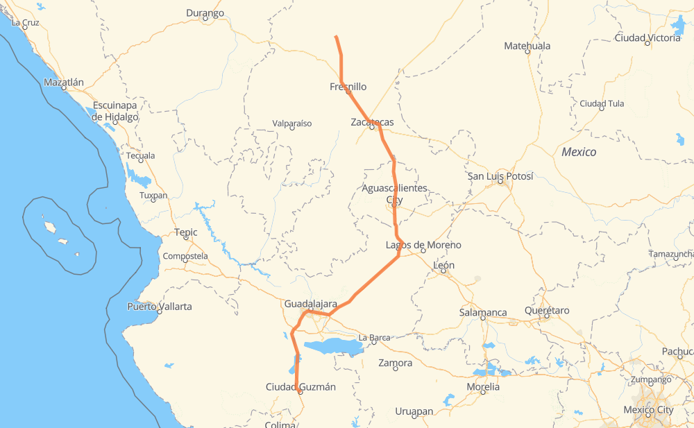
The distance from Ciudad Guzmán to Río Grande is 370 miles by road including 195 miles on motorways. Road takes approximately 6 hours and 29 minutes and goes through Tonalá, Aguascalientes, Fresnillo, Lomas de Santa Anita, Pegueros, Valle de Guadalupe and Encarnación de Díaz.
| Shortest distance by air | 286 mi ✈️ |
| Car route length | 369.7 mi 🚗 |
| Driving time | 6 h 29 min |
| Fuel amount | 12.6 gal |
| Fuel cost | 49.1 USD |
| Toll roads cost | 693 + ? MXN |
| Point | Distance | Time | Fuel | |
| Ciudad Guzmán | 0 mi | 00 min | 0.0 gal | |
|
MEX 54 MEX 54D 64 mi, 1 h 03 min
|
||||
| Lomas de Santa Anita | 64 mi | 1 h 03 min | 2.1 gal | |
|
MEX 15 MEX 80 25 mi, 29 min
|
||||
| Tonalá | 89 mi | 1 h 33 min | 2.8 gal | |
|
MEX 15D MEX 80D 42 mi, 40 min
|
||||
| Pegueros | 130 mi | 2 h 14 min | 4.2 gal | |
|
MEX 80D 11 mi, 09 min
|
||||
| Valle de Guadalupe | 140 mi | 2 h 23 min | 4.7 gal | |
|
MEX 80D 47 mi, 44 min
|
||||
| Encarnación de Díaz | 188 mi | 3 h 07 min | 6.3 gal | |
|
MEX 45D MEX 70 29 mi, 33 min
|
||||
| Aguascalientes | 217 mi | 3 h 41 min | 7.3 gal | |
|
MEX 45 13 mi, 15 min
|
||||
| San Francisco de Los Romo | 230 mi | 3 h 56 min | 7.8 gal | |
|
MEX 45 MEX 45D 94 mi, 1 h 41 min
|
||||
| Fresnillo | 324 mi | 5 h 37 min | 10.8 gal | |
|
MEX 45D MEX 49 48 mi, 51 min
|
||||
| Río Grande | 372 mi | 6 h 29 min | 12.6 gal | |
Hotels of Río Grande
Frequently Asked Questions
How many toll booths are there from Ciudad Guzmán to Río Grande?
There are 9 toll booths between Ciudad Guzmán and Río Grande: Morfín Chávez, Calera, Veta Grande, Zacatecas, Encarnacion De Diaz, Jalostotitlan, Tepatitlan, Sayula and La Joya.
How much does the toll booths cost from Ciudad Guzmán to Río Grande?
Toll roads cost: Sayula (?) + La Joya (?) + Tepatitlan (214 MXN) + Jalostotitlan (177 MXN) + Encarnacion De Diaz (150 MXN) + Zacatecas (41 MXN) + Veta Grande (48 MXN) + Calera (23 MXN) + Morfín Chávez (40 MXN) = 693 + ? MXN
How much does it cost to drive from Ciudad Guzmán to Río Grande?
Fuel cost: 49.1 USD
This fuel cost is calculated as: (Route length 369.7 mi) / (Fuel consumption 29.4 mpg) * (Fuel price 3.9 USD / gal)
You can adjust fuel consumption and fuel price here.
Toll roads cost: 693 + ? MXN
How long is a car ride from Ciudad Guzmán to Río Grande?
Driving time: 6 h 29 min
This time is calculated for driving at the maximum permitted speed, taking into account traffic rules restrictions.
- 86 mi with a maximum speed 68 mph = 1 h 15 min
- 83 mi with a maximum speed 62 mph = 1 h 19 min
- 110 mi with a maximum speed 56 mph = 1 h 58 min
- 32 mi with a maximum speed 56 mph = 34 min
- 46 mi with a maximum speed 50 mph = 55 min
- 4 mi with a maximum speed 43 mph = 5 min
- 9 mi with a maximum speed 37 mph = 14 min
- 2 mi with a maximum speed 31 mph = 3 min
- 1 mi with a maximum speed 25 mph = 1 min
- 1 mi with a maximum speed 19 mph = 1 min
The calculated driving time does not take into account intermediate stops and traffic jams.
How far is Ciudad Guzmán to Río Grande by land?
The distance between Ciudad Guzmán and Río Grande is 369.7 mi by road including 195.1 mi on motorways.
Precise satellite coordinates of highways were used for this calculation. The start and finish points are the centers of Ciudad Guzmán and Río Grande respectively.
How far is Ciudad Guzmán to Río Grande by plane?
The shortest distance (air line, as the crow flies) between Ciudad Guzmán and Río Grande is 286.5 mi.
This distance is calculated using the Haversine formula as a great-circle distance between two points on the surface of a sphere. The start and finish points are the centers of Ciudad Guzmán and Río Grande respectively. Actual distance between airports may be different.
How many hours is Ciudad Guzmán from Río Grande by plane?
Boeing 737 airliner needs 34 min to cover the distance of 286 mi at a cruising speed of 497 mph.
Small plane "Cessna 172" needs 2 h 5 min to flight this distance at average speed of 136 mph.
This time is approximate and do not take into account takeoff and landing times, airport location and other real world factors.
How long is a helicopter ride from Ciudad Guzmán to Río Grande?
Fast helicopter "Eurocopter AS350" or "Hughes OH-6 Cayuse" need 1 h 55 min to cover the distance of 286 mi at a cruising speed of 149 mph.
Popular "Robinson R44" needs 2 h 11 min to flight this distance at average speed of 130 mph.
This time is approximate and do not take into account takeoff and landing times, aerodrome location and other real world factors.
What city is halfway between Ciudad Guzmán and Río Grande?
The halfway point between Ciudad Guzmán and Río Grande is Encarnación de Díaz. It is located about 3 mi from the exact midpoint by road.
The distance from Encarnación de Díaz to Ciudad Guzmán is 188 mi and driving will take about 3 h 7 min. The road between Encarnación de Díaz and Río Grande has length 181 mi and will take approximately 3 h 21 min.
The other cities located close to halfway point:
Where is Ciudad Guzmán in relation to Río Grande?
Ciudad Guzmán is located 286 mi south of Río Grande.
Ciudad Guzmán has geographic coordinates: latitude 19.70206, longitude -103.46265.
Río Grande has geographic coordinates: latitude 23.82686, longitude -103.03381.
Which highway goes from Ciudad Guzmán to Río Grande?
The route from Ciudad Guzmán to Río Grande follows MEX 80D, MEX 45D, MEX 45, MEX 54D.
Other minor sections pass along the road:
- MEX 70: 48 mi
- MEX 49: 35 mi
- MEX 80: 22 mi
- MEX 15: 17 mi
- MEX 15D: 16 mi
- MEX 90: 5 mi
- MEX 23: 3 mi
- MEX 90D: 2 mi
- ZAC 49: 1 mi