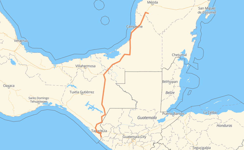
Distance between Ciudad Hidalgo and San Cristóbal Penxixin
The distance from Ciudad Hidalgo to San Cristóbal Penxixin is 613 miles by road including 24 miles on motorways. Road takes approximately 11 hours and 43 minutes and goes through Tapachula, Comitán de Dominguez, Metapa de Dominguez, Viva Mexico, Álvaro Obregón, Huehuetan and Huixtla.
| Shortest distance by air | 432 mi ✈️ |
| Car route length | 613.3 mi 🚗 |
| Driving time | 11 h 43 min |
| Fuel amount | 20.9 gal |
| Fuel cost | 81.3 USD |
| Toll roads cost | 101 MXN |
| Point | Distance | Time | Fuel | |
| 14.67973, -92.15033 | 0 mi | 00 min | 0.0 gal | |
|
MEX 200 13 mi, 15 min
|
||||
| Metapa de Dominguez | 13 mi | 15 min | 0.6 gal | |
|
MEX 200 11 mi, 12 min
|
||||
| Tapachula | 24 mi | 27 min | 1.1 gal | |
|
MEX 200 7 mi, 08 min
|
||||
| Álvaro Obregón | 32 mi | 36 min | 1.2 gal | |
|
MEX 200 7 mi, 08 min
|
||||
| Huehuetan | 40 mi | 44 min | 1.6 gal | |
|
MEX 200 11 mi, 12 min
|
||||
| Huixtla | 50 mi | 56 min | 1.9 gal | |
|
MEX 211 31 mi, 38 min
|
||||
| Motozintla de Mendoza | 81 mi | 1 h 34 min | 2.9 gal | |
|
MEX 211 34 mi, 41 min
|
||||
| Frontera Comalapa | 116 mi | 2 h 16 min | 4.0 gal | |
|
MEX 211 MEX 190 59 mi, 1 h 13 min
|
||||
| Comitán de Dominguez | 175 mi | 3 h 29 min | 6.1 gal | |
|
60 mi, 1 h 08 min
|
||||
| Ocosingo | 235 mi | 4 h 38 min | 8.2 gal | |
|
MEX 199 MEX 186 378 mi, 7 h 05 min
|
||||
| San Cristóbal Penxixin | 613 mi | 11 h 43 min | 21.2 gal | |
Frequently Asked Questions
How many toll booths are there from Ciudad Hidalgo to San Cristóbal Penxixin?
There are 2 toll booths between Ciudad Hidalgo and San Cristóbal Penxixin: Usumacinta and Seybaplaya.
How much does the toll booths cost from Ciudad Hidalgo to San Cristóbal Penxixin?
Toll roads cost: Usumacinta (24 MXN) + Seybaplaya (77 MXN) = 101 MXN
How much does it cost to drive from Ciudad Hidalgo to San Cristóbal Penxixin?
Fuel cost: 81.3 USD
This fuel cost is calculated as: (Route length 613.3 mi) / (Fuel consumption 29.4 mpg) * (Fuel price 3.9 USD / gal)
You can adjust fuel consumption and fuel price here.
Toll roads cost: 101 MXN
How long is a car ride from Ciudad Hidalgo to San Cristóbal Penxixin?
Driving time: 11 h 43 min
This time is calculated for driving at the maximum permitted speed, taking into account traffic rules restrictions.
- 24 mi with a maximum speed 68 mph = 21 min
- 168 mi with a maximum speed 56 mph = 2 h 59 min
- 109 mi with a maximum speed 56 mph = 1 h 57 min
- 277 mi with a maximum speed 50 mph = 5 h 34 min
- 24 mi with a maximum speed 43 mph = 33 min
- 9 mi with a maximum speed 37 mph = 14 min
- 2 mi with a maximum speed 31 mph = 3 min
The calculated driving time does not take into account intermediate stops and traffic jams.
How far is Ciudad Hidalgo to San Cristóbal Penxixin by land?
The distance between Ciudad Hidalgo and San Cristóbal Penxixin is 613.3 mi by road including 24.2 mi on motorways.
Precise satellite coordinates of highways were used for this calculation. The start and finish points are the centers of Ciudad Hidalgo and San Cristóbal Penxixin respectively.
How far is Ciudad Hidalgo to San Cristóbal Penxixin by plane?
The shortest distance (air line, as the crow flies) between Ciudad Hidalgo and San Cristóbal Penxixin is 432.5 mi.
This distance is calculated using the Haversine formula as a great-circle distance between two points on the surface of a sphere. The start and finish points are the centers of Ciudad Hidalgo and San Cristóbal Penxixin respectively. Actual distance between airports may be different.
How many hours is Ciudad Hidalgo from San Cristóbal Penxixin by plane?
Boeing 737 airliner needs 52 min to cover the distance of 432 mi at a cruising speed of 497 mph.
Small plane "Cessna 172" needs 3 h 9 min to flight this distance at average speed of 136 mph.
This time is approximate and do not take into account takeoff and landing times, airport location and other real world factors.
How long is a helicopter ride from Ciudad Hidalgo to San Cristóbal Penxixin?
Fast helicopter "Eurocopter AS350" or "Hughes OH-6 Cayuse" need 2 h 54 min to cover the distance of 432 mi at a cruising speed of 149 mph.
Popular "Robinson R44" needs 3 h 18 min to flight this distance at average speed of 130 mph.
This time is approximate and do not take into account takeoff and landing times, aerodrome location and other real world factors.
What city is halfway between Ciudad Hidalgo and San Cristóbal Penxixin?
The halfway point between Ciudad Hidalgo and San Cristóbal Penxixin is Palenque. It is located about 3 mi from the exact midpoint by road.
The distance from Palenque to Ciudad Hidalgo is 309 mi and driving will take about 6 h 5 min. The road between Palenque and San Cristóbal Penxixin has length 303 mi and will take approximately 5 h 38 min.
The other cities located close to halfway point:
Where is Ciudad Hidalgo in relation to San Cristóbal Penxixin?
Ciudad Hidalgo is located 432 mi south-west of San Cristóbal Penxixin.
Ciudad Hidalgo has geographic coordinates: latitude 14.67973, longitude -92.15033.
San Cristóbal Penxixin has geographic coordinates: latitude 20.53259, longitude -89.81473.
Which highway goes from Ciudad Hidalgo to San Cristóbal Penxixin?
The route from Ciudad Hidalgo to San Cristóbal Penxixin follows MEX 186, MEX 199, MEX 180, MEX 211.
Other minor sections pass along the road:
- MEX 261: 50 mi
- MEX 190: 47 mi
- MEX 200: 40 mi
- MEX 180D: 24 mi
- MEX 184: 9 mi
- 186: 1 mi