Distance between Ciudad López Mateos and Chabac
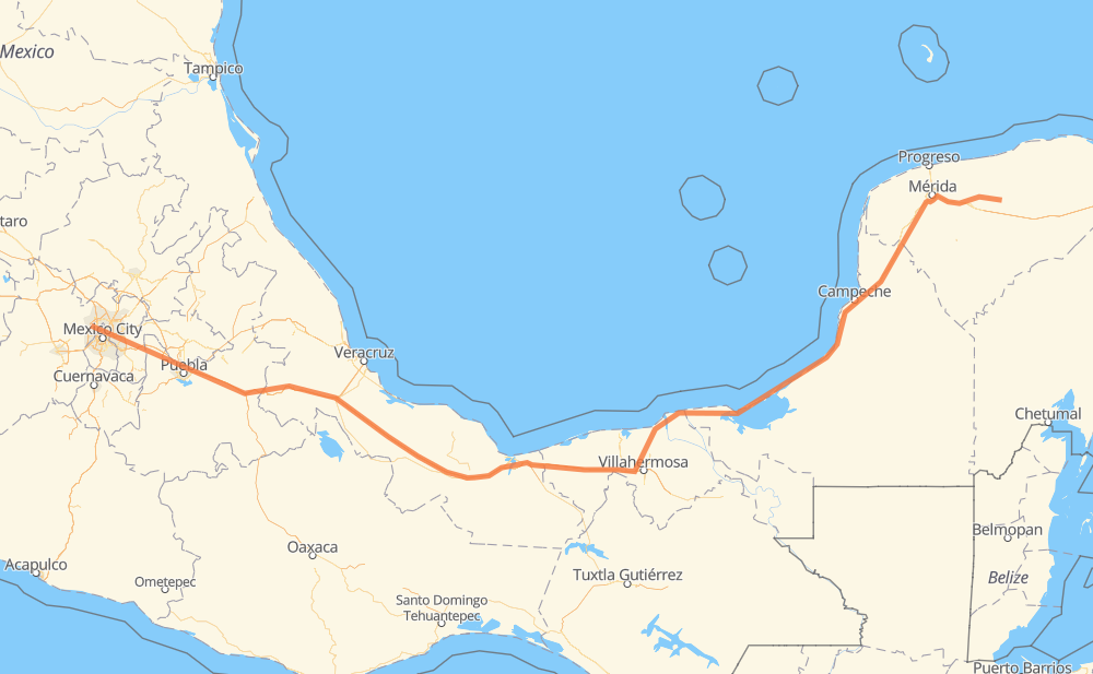
The distance from Ciudad López Mateos to Chabac is 884 miles by road including 455 miles on motorways. Road takes approximately 16 hours and 10 minutes and goes through Orizaba, Mérida, Kanasín and Izamal.
| Shortest distance by air | 683 mi ✈️ |
| Car route length | 883.6 mi 🚗 |
| Driving time | 16 h 10 min |
| Fuel amount | 30.1 gal |
| Fuel cost | 118.1 USD |
| Toll roads cost | 1,097 + ? MXN |
| Point | Distance | Time | Fuel | |
| Ciudad López Mateos | 0 mi | 00 min | 0.0 gal | |
|
6 mi, 07 min
|
||||
| Tlalnepantla | 6 mi | 07 min | 0.2 gal | |
|
4 mi, 04 min
|
||||
| Naucalpan de Juarez | 9 mi | 11 min | 0.3 gal | |
|
Periferico Norte 4 mi, 04 min
|
||||
| Miguel Hidalgo | 12 mi | 15 min | 0.4 gal | |
|
Periferico Norte Periférico 8 mi, 08 min
|
||||
| Venustiano Carranza | 21 mi | 24 min | 0.6 gal | |
|
1S MEX 150D 164 mi, 3 h 07 min
|
||||
| Orizaba | 185 mi | 3 h 31 min | 6.2 gal | |
|
MEX 150D MEX 180 642 mi, 11 h 26 min
|
||||
| Mérida | 827 mi | 14 h 58 min | 28.0 gal | |
|
15 mi, 17 min
|
||||
| Kanasín | 843 mi | 15 h 15 min | 28.2 gal | |
|
MEX 180 YUC 11 30 mi, 36 min
|
||||
| Izamal | 872 mi | 15 h 52 min | 29.6 gal | |
|
14 mi, 17 min
|
||||
| Chabac | 886 mi | 16 h 10 min | 30.1 gal | |
Frequently Asked Questions
How many toll booths are there from Ciudad López Mateos to Chabac?
There are 17 toll booths between Ciudad López Mateos and Chabac: Fortín, Cuitláhuac, Cosamaloapan, Acayucan, Antonio Dovali, San Marcos 7, San Martín, Viaducto Elevado de Puebla, Amozoc, Esperanza 27, Sánchez Magallanes, Villahermosa Nacajuca, Zacatal, Unidad, Seybaplaya, Viaducto Bicentenario - Santa Mónica and Urbana Norte - Viaducto Minería.
How much does the toll booths cost from Ciudad López Mateos to Chabac?
Toll roads cost: Viaducto Bicentenario - Santa Mónica (?) + Urbana Norte - Viaducto Minería (?) + San Marcos 7 (136 MXN) + San Martín (42 MXN) + Viaducto Elevado de Puebla (?) + Amozoc (72 MXN) + Esperanza 27 (140 MXN) + Fortín (33 MXN) + Cuitláhuac (114 MXN) + Cosamaloapan (229 MXN) + Acayucan (?) + Antonio Dovali (20 MXN) + Sánchez Magallanes (82 MXN) + Villahermosa Nacajuca (62 MXN) + Zacatal (90 MXN) + Unidad (?) + Seybaplaya (77 MXN) = 1,097 + ? MXN
How much does it cost to drive from Ciudad López Mateos to Chabac?
Fuel cost: 118.1 USD
This fuel cost is calculated as: (Route length 883.6 mi) / (Fuel consumption 29.4 mpg) * (Fuel price 3.93 USD / gal)
You can adjust fuel consumption and fuel price here.
Toll roads cost: 1,097 + ? MXN
How long is a car ride from Ciudad López Mateos to Chabac?
Driving time: 16 h 10 min
This time is calculated for driving at the maximum permitted speed, taking into account traffic rules restrictions.
- 85 mi with a maximum speed 68 mph = 1 h 15 min
- 216 mi with a maximum speed 62 mph = 3 h 28 min
- 119 mi with a maximum speed 56 mph = 2 h 6 min
- 84 mi with a maximum speed 56 mph = 1 h 29 min
- 352 mi with a maximum speed 50 mph = 7 h 5 min
- 24 mi with a maximum speed 43 mph = 33 min
- 2 mi with a maximum speed 37 mph = 4 min
- 2 mi with a maximum speed 31 mph = 3 min
- 1 mi with a maximum speed 25 mph = 2 min
The calculated driving time does not take into account intermediate stops and traffic jams.
How far is Ciudad López Mateos to Chabac by land?
The distance between Ciudad López Mateos and Chabac is 883.6 mi by road including 455.5 mi on motorways.
Precise satellite coordinates of highways were used for this calculation. The start and finish points are the centers of Ciudad López Mateos and Chabac respectively.
How far is Ciudad López Mateos to Chabac by plane?
The shortest distance (air line, as the crow flies) between Ciudad López Mateos and Chabac is 682.9 mi.
This distance is calculated using the Haversine formula as a great-circle distance between two points on the surface of a sphere. The start and finish points are the centers of Ciudad López Mateos and Chabac respectively. Actual distance between airports may be different.
How many hours is Ciudad López Mateos from Chabac by plane?
Boeing 737 airliner needs 1 h 22 min to cover the distance of 683 mi at a cruising speed of 497 mph.
Small plane "Cessna 172" needs 4 h 59 min to flight this distance at average speed of 136 mph.
This time is approximate and do not take into account takeoff and landing times, airport location and other real world factors.
How long is a helicopter ride from Ciudad López Mateos to Chabac?
Fast helicopter "Eurocopter AS350" or "Hughes OH-6 Cayuse" need 4 h 34 min to cover the distance of 683 mi at a cruising speed of 149 mph.
Popular "Robinson R44" needs 5 h 14 min to flight this distance at average speed of 130 mph.
This time is approximate and do not take into account takeoff and landing times, aerodrome location and other real world factors.
What city is halfway between Ciudad López Mateos and Chabac?
The halfway point between Ciudad López Mateos and Chabac is Heroica Cárdenas. It is located about 13 mi from the exact midpoint by road.
The distance from Heroica Cárdenas to Ciudad López Mateos is 455 mi and driving will take about 8 h. The road between Heroica Cárdenas and Chabac has length 429 mi and will take approximately 8 h 10 min.
The other cities located close to halfway point:
Where is Ciudad López Mateos in relation to Chabac?
Ciudad López Mateos is located 683 mi west of Chabac.
Ciudad López Mateos has geographic coordinates: latitude 19.5614, longitude -99.26199.
Chabac has geographic coordinates: latitude 20.91103, longitude -88.83011.
Which highway goes from Ciudad López Mateos to Chabac?
The route from Ciudad López Mateos to Chabac follows MEX 180, MEX 150D, MEX 145D, MEX 180D.
Other minor sections pass along the road:
- MEX 190: 4 mi
- Periferico Norte: 4 mi
- YUC 11: 2 mi