Distance between Cohuecan and Guadalupe Piletas (Puente Negro)
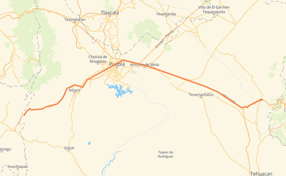
The distance from Cohuecan to Guadalupe Piletas (Puente Negro) is 104 miles by road including 94 miles on motorways. Road takes approximately 1 hour and 57 minutes and goes through Puebla, Acatzingo de Hidalgo, Palmarito Tochapan and Cuacnopalan.
| Shortest distance by air | 87 mi ✈️ |
| Car route length | 103.8 mi 🚗 |
| Driving time | 1 h 57 min |
| Fuel amount | 3.5 gal |
| Fuel cost | 13.9 USD |
| Toll roads cost | 144 + ? MXN |
| Point | Distance | Time | Fuel | |
| Cohuecan | 0 mi | 00 min | 0.0 gal | |
|
PUE 438D 9 mi, 11 min
|
||||
| San Juan Tejupa | 9 mi | 11 min | 0.1 gal | |
|
PUE 438D 12 mi, 13 min
|
||||
| Metepec | 22 mi | 25 min | 0.7 gal | |
|
PUE 438D 7 mi, 07 min
|
||||
| Santa Ana Acozautla | 29 mi | 32 min | 1.0 gal | |
|
MEX 190D 3 mi, 04 min
|
||||
| San Bernardino Chalchihuapan | 32 mi | 36 min | 1.0 gal | |
|
MEX 190D 12 mi, 13 min
|
||||
| Puebla | 43 mi | 49 min | 1.4 gal | |
|
MEX 190D MEX 150D 34 mi, 34 min
|
||||
| Acatzingo de Hidalgo | 78 mi | 1 h 24 min | 2.5 gal | |
|
MEX 150D 9 mi, 09 min
|
||||
| Palmarito Tochapan | 86 mi | 1 h 33 min | 2.9 gal | |
|
MEX 150D 8 mi, 09 min
|
||||
| Cuacnopalan | 94 mi | 1 h 42 min | 3.0 gal | |
|
MEX 150D 12 mi, 14 min
|
||||
| Guadalupe Piletas (Puente Negro) | 106 mi | 1 h 57 min | 3.6 gal | |
Frequently Asked Questions
How many toll booths are there from Cohuecan to Guadalupe Piletas (Puente Negro)?
There are 4 toll booths between Cohuecan and Guadalupe Piletas (Puente Negro): Amozoc, Esperanza 27, Vía Atlixcayotl and Siglo XXI.
How much does the toll booths cost from Cohuecan to Guadalupe Piletas (Puente Negro)?
Toll roads cost: Siglo XXI (?) + Vía Atlixcayotl (?) + Amozoc (72 MXN) + Esperanza 27 (72 MXN) = 144 + ? MXN
How much does it cost to drive from Cohuecan to Guadalupe Piletas (Puente Negro)?
Fuel cost: 13.9 USD
This fuel cost is calculated as: (Route length 103.8 mi) / (Fuel consumption 29.4 mpg) * (Fuel price 3.93 USD / gal)
You can adjust fuel consumption and fuel price here.
Toll roads cost: 144 + ? MXN
How long is a car ride from Cohuecan to Guadalupe Piletas (Puente Negro)?
Driving time: 1 h 57 min
This time is calculated for driving at the maximum permitted speed, taking into account traffic rules restrictions.
- 19 mi with a maximum speed 68 mph = 16 min
- 24 mi with a maximum speed 62 mph = 23 min
- 61 mi with a maximum speed 50 mph = 1 h 13 min
- 1 mi with a maximum speed 31 mph = 2 min
The calculated driving time does not take into account intermediate stops and traffic jams.
How far is Cohuecan to Guadalupe Piletas (Puente Negro) by land?
The distance between Cohuecan and Guadalupe Piletas (Puente Negro) is 103.8 mi by road including 94.4 mi on motorways.
Precise satellite coordinates of highways were used for this calculation. The start and finish points are the centers of Cohuecan and Guadalupe Piletas (Puente Negro) respectively.
How far is Cohuecan to Guadalupe Piletas (Puente Negro) by plane?
The shortest distance (air line, as the crow flies) between Cohuecan and Guadalupe Piletas (Puente Negro) is 87 mi.
This distance is calculated using the Haversine formula as a great-circle distance between two points on the surface of a sphere. The start and finish points are the centers of Cohuecan and Guadalupe Piletas (Puente Negro) respectively. Actual distance between airports may be different.
How many hours is Cohuecan from Guadalupe Piletas (Puente Negro) by plane?
Boeing 737 airliner needs 10 min to cover the distance of 87 mi at a cruising speed of 497 mph.
Small plane "Cessna 172" needs 38 min to flight this distance at average speed of 136 mph.
This time is approximate and do not take into account takeoff and landing times, airport location and other real world factors.
How long is a helicopter ride from Cohuecan to Guadalupe Piletas (Puente Negro)?
Fast helicopter "Eurocopter AS350" or "Hughes OH-6 Cayuse" need 35 min to cover the distance of 87 mi at a cruising speed of 149 mph.
Popular "Robinson R44" needs 40 min to flight this distance at average speed of 130 mph.
This time is approximate and do not take into account takeoff and landing times, aerodrome location and other real world factors.
What city is halfway between Cohuecan and Guadalupe Piletas (Puente Negro)?
The halfway point between Cohuecan and Guadalupe Piletas (Puente Negro) is San Jacinto. It is located about 4 mi from the exact midpoint by road.
The distance from San Jacinto to Cohuecan is 55 mi and driving will take about 1 h 3 min. The road between San Jacinto and Guadalupe Piletas (Puente Negro) has length 48 mi and will take approximately 53 min.
The other cities located close to halfway point:
Where is Cohuecan in relation to Guadalupe Piletas (Puente Negro)?
Cohuecan is located 87 mi west of Guadalupe Piletas (Puente Negro).
Cohuecan has geographic coordinates: latitude 18.78362, longitude -98.72052.
Guadalupe Piletas (Puente Negro) has geographic coordinates: latitude 18.86333, longitude -97.39444.
Which highway goes from Cohuecan to Guadalupe Piletas (Puente Negro)?
The route from Cohuecan to Guadalupe Piletas (Puente Negro) follows MEX 150D.
Other minor sections pass along the road:
- PUE 438D: 26 mi
- MEX 190D: 14 mi
- MEX 144: 1 mi