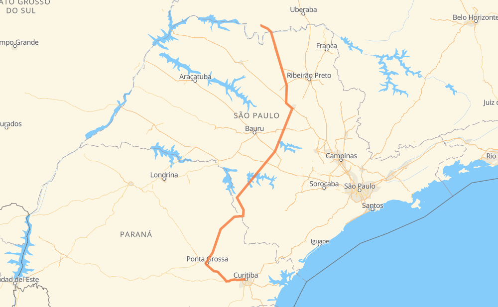
Distance between Curitiba and Frutal
The distance from Curitiba to Frutal is 523 miles by road including 168 miles on motorways. Road takes approximately 9 hours and 17 minutes and goes through Campo Largo, Mercês, Cará-Cará, Praça do Jardim Canaã, Centro, Jardim Regina and Bairro da Serrinha.
| Shortest distance by air | 374 mi ✈️ |
| Car route length | 523.2 mi 🚗 |
| Driving time | 9 h 17 min |
| Fuel amount | 17.8 gal |
| Fuel cost | 69.9 USD |
| Point | Distance | Time | Fuel | |
| Curitiba | 0 mi | 00 min | 0.0 gal | |
|
2 mi, 02 min
|
||||
| Mercês | 2 mi | 02 min | 0.0 gal | |
|
BR-277 16 mi, 16 min
|
||||
| Campo Largo | 17 mi | 19 min | 0.5 gal | |
|
BR-277 BR-376 47 mi, 43 min
|
||||
| Cará-Cará | 63 mi | 1 h 03 min | 2.1 gal | |
|
BR-376 7 mi, 07 min
|
||||
| Praça do Jardim Canaã | 71 mi | 1 h 10 min | 2.4 gal | |
|
BR-376 PR-151 90 mi, 1 h 38 min
|
||||
| Centro | 162 mi | 2 h 49 min | 5.3 gal | |
|
PR-151 PR-239 15 mi, 17 min
|
||||
| Jardim Regina | 176 mi | 3 h 06 min | 6.0 gal | |
|
SP-258 SP-281 15 mi, 18 min
|
||||
| Bairro da Serrinha | 191 mi | 3 h 24 min | 6.2 gal | |
|
SP-281 11 mi, 12 min
|
||||
| Bairro do Rola-Burro | 202 mi | 3 h 36 min | 6.8 gal | |
|
SP-281 SP-255 321 mi, 5 h 40 min
|
||||
| Frutal | 523 mi | 9 h 17 min | 17.7 gal | |
Frequently Asked Questions
How much does it cost to drive from Curitiba to Frutal?
Fuel cost: 69.9 USD
This fuel cost is calculated as: (Route length 523.2 mi) / (Fuel consumption 29.4 mpg) * (Fuel price 3.93 USD / gal)
You can adjust fuel consumption and fuel price here.
How long is a car ride from Curitiba to Frutal?
Driving time: 9 h 17 min
This time is calculated for driving at the maximum permitted speed, taking into account traffic rules restrictions.
- 104 mi with a maximum speed 68 mph = 1 h 31 min
- 52 mi with a maximum speed 62 mph = 50 min
- 271 mi with a maximum speed 56 mph = 4 h 50 min
- 85 mi with a maximum speed 50 mph = 1 h 42 min
- 5 mi with a maximum speed 37 mph = 7 min
- 6 mi with a maximum speed 25 mph = 14 min
The calculated driving time does not take into account intermediate stops and traffic jams.
How far is Curitiba to Frutal by land?
The distance between Curitiba and Frutal is 523.2 mi by road including 167.8 mi on motorways.
Precise satellite coordinates of highways were used for this calculation. The start and finish points are the centers of Curitiba and Frutal respectively.
How far is Curitiba to Frutal by plane?
The shortest distance (air line, as the crow flies) between Curitiba and Frutal is 374.1 mi.
This distance is calculated using the Haversine formula as a great-circle distance between two points on the surface of a sphere. The start and finish points are the centers of Curitiba and Frutal respectively. Actual distance between airports may be different.
How many hours is Curitiba from Frutal by plane?
Boeing 737 airliner needs 45 min to cover the distance of 374 mi at a cruising speed of 497 mph.
Small plane "Cessna 172" needs 2 h 44 min to flight this distance at average speed of 136 mph.
This time is approximate and do not take into account takeoff and landing times, airport location and other real world factors.
How long is a helicopter ride from Curitiba to Frutal?
Fast helicopter "Eurocopter AS350" or "Hughes OH-6 Cayuse" need 2 h 30 min to cover the distance of 374 mi at a cruising speed of 149 mph.
Popular "Robinson R44" needs 2 h 52 min to flight this distance at average speed of 130 mph.
This time is approximate and do not take into account takeoff and landing times, aerodrome location and other real world factors.
What city is halfway between Curitiba and Frutal?
The halfway point between Curitiba and Frutal is Porto Taquari. It is located about 22 mi from the exact midpoint by road.
The distance from Porto Taquari to Curitiba is 239 mi and driving will take about 4 h 20 min. The road between Porto Taquari and Frutal has length 283 mi and will take approximately 4 h 56 min.
The other cities located close to halfway point:
Where is Curitiba in relation to Frutal?
Curitiba is located 374 mi south of Frutal.
Curitiba has geographic coordinates: latitude -25.4296, longitude -49.27127.
Frutal has geographic coordinates: latitude -20.02202, longitude -48.92801.
Which highway goes from Curitiba to Frutal?
The route from Curitiba to Frutal follows SP-255, SP-326, PR-151, BR-364.
Other minor sections pass along the road:
- BR-272: 43 mi
- BR-376: 42 mi
- SP-281: 34 mi
- BR-277: 28 mi
- SP-310: 11 mi
- PR-239: 7 mi
- BR-267: 7 mi
- PRC-373: 5 mi
- BR-369: 3 mi
- SP-258: 2 mi
- PR 151: 2 mi
- SP-304: 1 mi
- SPI 274/310: 1 mi
- PR 151: 1 mi