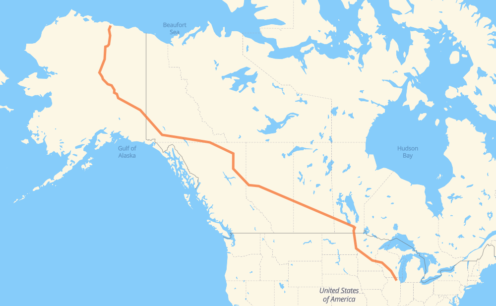
Distance between Deadhorse AK and Fox River Farms IL
The distance from Deadhorse to Fox River Farms is 3,949 miles by road including 818 miles on motorways. Road takes approximately 70 hours and 55 minutes and goes through Whitehorse, Fort St. John, Dawson Creek, Spruce Grove, Edmonton, Lloydminster and North Battleford.
You can adjust fuel consumption and fuel price here.
How long is a car ride from Deadhorse to Fox River Farms?
Driving time:
70 h 55 min
This time is calculated for driving at the maximum permitted speed, taking into account traffic rules restrictions.
508 mi with a maximum speed 68 mph = 7 h 28 min
16 mi with a maximum speed 65 mph = 14 min
149 mi with a maximum speed 62 mph = 2 h 24 min
27 mi with a maximum speed 60 mph = 27 min
2,225 mi with a maximum speed 56 mph = 39 h 43 min
57 mi with a maximum speed 56 mph = 1 h
52 mi with a maximum speed 55 mph = 56 min
367 mi with a maximum speed 50 mph = 7 h 20 min
495 mi with a maximum speed 50 mph = 9 h 57 min
6 mi with a maximum speed 45 mph = 7 min
30 mi with a maximum speed 43 mph = 41 min
6 mi with a maximum speed 37 mph = 9 min
1 mi with a maximum speed 35 mph = 1 min
11 mi with a maximum speed 31 mph = 20 min
The calculated driving time does not take into account intermediate stops and traffic jams.
How far is Deadhorse to Fox River Farms by land?
The distance between Deadhorse and Fox River Farms is 3,949.4 mi by road including 817.7 mi on motorways.
Precise satellite coordinates of highways were used for this calculation. The start and finish points are the centers of Deadhorse and Fox River Farms respectively.
How far is Deadhorse to Fox River Farms by plane?
The shortest distance (air line, as the crow flies) between Deadhorse and Fox River Farms is 2,830.3 mi.
This distance is calculated using the Haversine formula as a great-circle distance between two points on the surface of a sphere. The start and finish points are the centers of Deadhorse and Fox River Farms respectively. Actual distance between airports may be different.
How many hours is Deadhorse from Fox River Farms by plane?
Boeing 737 airliner needs 5 h 41 min to cover the distance of 2,830 mi at a cruising speed of 497 mph.
Small plane "Cessna 172" needs 20 h 42 min to flight this distance at average speed of 136 mph.
This time is approximate and do not take into account takeoff and landing times, airport location and other real world factors.
How long is a helicopter ride from Deadhorse to Fox River Farms?
Fast helicopter "Eurocopter AS350" or "Hughes OH-6 Cayuse" need 18 h 58 min to cover the distance of 2,830 mi at a cruising speed of 149 mph.
Popular "Robinson R44" needs 21 h 41 min to flight this distance at average speed of 130 mph.
This time is approximate and do not take into account takeoff and landing times, aerodrome location and other real world factors.
What city is halfway between Deadhorse and Fox River Farms?
The halfway point between Deadhorse and Fox River Farms is Pouce Coupe. It is located about 14 mi from the exact midpoint by road.
The distance from Pouce Coupe to Deadhorse is 1,961 mi and driving will take about 36 h 39 min. The road between Pouce Coupe and Fox River Farms has length 1,989 mi and will take approximately 34 h 16 min.
The other cities located close to halfway point:
Dawson Creek is in 1,953 mi from Deadhorse and 1,996 mi from Fox River Farms
Beaverlodge is in 2,006 mi from Deadhorse and 1,944 mi from Fox River Farms
Pine Valley is in 1,930 mi from Deadhorse and 2,020 mi from Fox River Farms
Where is Deadhorse in relation to Fox River Farms?
Deadhorse is located 2,830 mi north-west of Fox River Farms.
Deadhorse has geographic coordinates: latitude 70.2007, longitude -148.45982.
Fox River Farms has geographic coordinates: latitude 42.03307, longitude -88.33244.
Which highway goes from Deadhorse to Fox River Farms?
The route from Deadhorse to Fox River Farms follows 16, 97, 1, I 94, AK 11, AK 2, 43, I 90, PTH 16, I 29, US 81, I 39, 2.