Distance between Delta ON and Vancouver BC
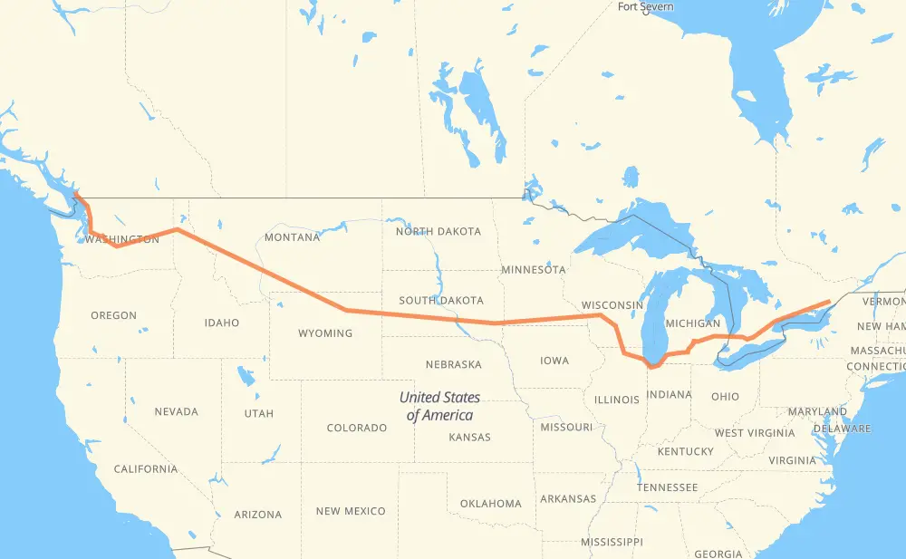
The distance from Delta to Vancouver is 2,938 miles by road including 2,884 miles on motorways. Road takes approximately 44 hours and 45 minutes and goes through Kingston, Belleville, Oshawa, Ajax, Toronto, Mississauga and Kitchener.
| Shortest distance by air | 2,205 mi ✈️ |
| Car route length | 2,937.8 mi 🚗 |
| Driving time | 44 h 45 min |
| Fuel amount | 99.9 gal |
| Fuel cost | 392.7 USD |
| Point | Distance | Time | Fuel | |
| Delta | 0 mi | 00 min | 0.0 gal | |
|
CR 42 CR 33 27 mi, 30 min
|
||||
| Kingston | 27 mi | 30 min | 0.4 gal | |
|
15 401 52 mi, 52 min
|
||||
| Belleville | 80 mi | 1 h 22 min | 2.5 gal | |
|
401 78 mi, 1 h 15 min
|
||||
| Oshawa | 157 mi | 2 h 37 min | 5.3 gal | |
|
401 9 mi, 08 min
|
||||
| Ajax | 167 mi | 2 h 46 min | 5.6 gal | |
|
401 20 mi, 19 min
|
||||
| Toronto | 186 mi | 3 h 05 min | 5.9 gal | |
|
401 19 mi, 18 min
|
||||
| Mississauga | 206 mi | 3 h 24 min | 6.8 gal | |
|
401 41 mi, 39 min
|
||||
| Kitchener | 247 mi | 4 h 03 min | 8.3 gal | |
|
401 26 mi, 25 min
|
||||
| Woodstock | 273 mi | 4 h 29 min | 9.2 gal | |
|
401 402 87 mi, 1 h 19 min
|
||||
| Sarnia | 360 mi | 5 h 48 min | 12.0 gal | |
|
402 I 69 76 mi, 1 h 13 min
|
||||
| Flint | 436 mi | 7 h 01 min | 14.7 gal | |
|
I 69 62 mi, 54 min
|
||||
| Lansing | 496 mi | 7 h 56 min | 16.8 gal | |
|
I 69 63 mi, 55 min
|
||||
| Kalamazoo | 560 mi | 8 h 51 min | 19.0 gal | |
|
I 94 I 90 254 mi, 3 h 54 min
|
||||
| Janesville | 814 mi | 12 h 46 min | 27.6 gal | |
|
I 39 35 mi, 30 min
|
||||
| Madison | 849 mi | 13 h 17 min | 28.7 gal | |
|
I 39 I 90 421 mi, 6 h 11 min
|
||||
| Brandon | 1,269 mi | 19 h 28 min | 43.1 gal | |
|
I 90 7 mi, 06 min
|
||||
| Sioux Falls | 1,276 mi | 19 h 34 min | 43.3 gal | |
|
I 90 72 mi, 1 h 03 min
|
||||
| Mitchell | 1,349 mi | 20 h 38 min | 45.6 gal | |
|
I 90 255 mi, 3 h 45 min
|
||||
| Box Elder | 1,604 mi | 24 h 24 min | 54.4 gal | |
|
I 90 12 mi, 10 min
|
||||
| Rapid City | 1,616 mi | 24 h 34 min | 54.9 gal | |
|
I 90 42 mi, 37 min
|
||||
| Spearfish | 1,658 mi | 25 h 11 min | 56.2 gal | |
|
I 90 97 mi, 1 h 29 min
|
||||
| Gillette | 1,755 mi | 26 h 41 min | 59.5 gal | |
|
I 90 99 mi, 1 h 34 min
|
||||
| Sheridan | 1,854 mi | 28 h 16 min | 62.8 gal | |
|
I 90 134 mi, 2 h 03 min
|
||||
| Billings | 1,988 mi | 30 h 19 min | 67.5 gal | |
|
I 90 226 mi, 3 h 20 min
|
||||
| Butte | 2,214 mi | 33 h 40 min | 74.8 gal | |
|
I 90 115 mi, 1 h 41 min
|
||||
| Missoula | 2,329 mi | 35 h 22 min | 79.1 gal | |
|
I 90 165 mi, 2 h 28 min
|
||||
| Coeur d'Alene | 2,494 mi | 37 h 50 min | 84.7 gal | |
|
I 90 34 mi, 31 min
|
||||
| Spokane | 2,528 mi | 38 h 21 min | 85.8 gal | |
|
I 90 111 mi, 1 h 38 min
|
||||
| Moses Lake | 2,639 mi | 40 h 00 min | 89.2 gal | |
|
I 90 158 mi, 2 h 21 min
|
||||
| Bellevue | 2,797 mi | 42 h 21 min | 95.0 gal | |
|
I 405 28 mi, 28 min
|
||||
| Everett | 2,824 mi | 42 h 49 min | 95.9 gal | |
|
I 5 59 mi, 55 min
|
||||
| Bellingham | 2,883 mi | 43 h 44 min | 97.8 gal | |
|
I 5 99 56 mi, 1 h 01 min
|
||||
| Vancouver | 2,939 mi | 44 h 45 min | 99.8 gal | |
Hotels of Vancouver
Frequently Asked Questions
How much does it cost to drive from Delta to Vancouver?
Fuel cost: 392.7 USD
This fuel cost is calculated as: (Route length 2,937.8 mi) / (Fuel consumption 29.4 mpg) * (Fuel price 3.93 USD / gal)
You can adjust fuel consumption and fuel price here.
How long is a car ride from Delta to Vancouver?
Driving time: 44 h 45 min
This time is calculated for driving at the maximum permitted speed, taking into account traffic rules restrictions.
- 2,165 mi with a maximum speed 68 mph = 31 h 50 min
- 116 mi with a maximum speed 65 mph = 1 h 46 min
- 449 mi with a maximum speed 62 mph = 7 h 13 min
- 93 mi with a maximum speed 60 mph = 1 h 33 min
- 11 mi with a maximum speed 56 mph = 11 min
- 4 mi with a maximum speed 56 mph = 4 min
- 12 mi with a maximum speed 55 mph = 13 min
- 75 mi with a maximum speed 50 mph = 1 h 30 min
- 2 mi with a maximum speed 45 mph = 2 min
- 2 mi with a maximum speed 43 mph = 3 min
- 1 mi with a maximum speed 40 mph = 1 min
- 1 mi with a maximum speed 37 mph = 2 min
- 6 mi with a maximum speed 31 mph = 10 min
The calculated driving time does not take into account intermediate stops and traffic jams.
How far is Delta to Vancouver by land?
The distance between Delta and Vancouver is 2,937.8 mi by road including 2,884.4 mi on motorways.
Precise satellite coordinates of highways were used for this calculation. The start and finish points are the centers of Delta and Vancouver respectively.
How far is Delta to Vancouver by plane?
The shortest distance (air line, as the crow flies) between Delta and Vancouver is 2,204.6 mi.
This distance is calculated using the Haversine formula as a great-circle distance between two points on the surface of a sphere. The start and finish points are the centers of Delta and Vancouver respectively. Actual distance between airports may be different.
How many hours is Delta from Vancouver by plane?
Boeing 737 airliner needs 4 h 26 min to cover the distance of 2,205 mi at a cruising speed of 497 mph.
Small plane "Cessna 172" needs 16 h 7 min to flight this distance at average speed of 136 mph.
This time is approximate and do not take into account takeoff and landing times, airport location and other real world factors.
How long is a helicopter ride from Delta to Vancouver?
Fast helicopter "Eurocopter AS350" or "Hughes OH-6 Cayuse" need 14 h 47 min to cover the distance of 2,205 mi at a cruising speed of 149 mph.
Popular "Robinson R44" needs 16 h 53 min to flight this distance at average speed of 130 mph.
This time is approximate and do not take into account takeoff and landing times, aerodrome location and other real world factors.
What city is halfway between Delta and Vancouver?
The halfway point between Delta and Vancouver is Kennebec. It is located about 32 mi from the exact midpoint by road.
The distance from Kennebec to Delta is 1,437 mi and driving will take about 21 h 54 min. The road between Kennebec and Vancouver has length 1,501 mi and will take approximately 22 h 50 min.
The other cities located close to halfway point:
Where is Delta in relation to Vancouver?
Delta is located 2,205 mi east of Vancouver.
Delta has geographic coordinates: latitude 44.60914, longitude -76.12262.
Vancouver has geographic coordinates: latitude 49.26243, longitude -123.11554.
Which highway goes from Delta to Vancouver?
The route from Delta to Vancouver follows I 90, 401, I 94, US 14, I 69, US 87, I 39, I 5, US 212, US 12, 402.
Other minor sections pass along the road:
- US 395: 59 mi
- US 191: 57 mi
- SD 79: 31 mi
- US 16: 25 mi
- 99: 24 mi
- 15: 21 mi
- US 83: 19 mi
- US 51: 19 mi
- I 405: 19 mi
- US 41: 14 mi
- MT 200: 14 mi
- CR 33: 9 mi
- I 15: 7 mi
- US 85: 7 mi
- US 89: 7 mi
- SD 63: 7 mi
- SD 73: 6 mi
- SD 50: 6 mi
- SD 34: 6 mi
- US 93: 5 mi
- I 96: 5 mi
- SD 45: 4 mi
- US 61: 4 mi
- US 16 Truck: 4 mi
- US 97: 4 mi
- US 31: 3 mi
- US 2: 2 mi
- MN 43: 2 mi
- US 218: 2 mi
- CR 42: 2 mi
- US 20: 2 mi
- WI 11: 2 mi
- SD 37: 1 mi
- US 53: 1 mi
- WA 543: 1 mi