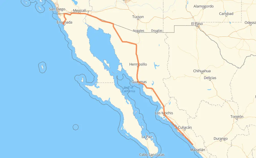
Distance between Dimas (Estación Dimas) and Ensenada
The distance from Dimas (Estación Dimas) to Ensenada is 1,086 miles by road including 717 miles on motorways. Road takes approximately 19 hours and 37 minutes and goes through Gabriel Leyva Solano, Los Mochis, Navojoa, Hermosillo, Heroica Caborca and San Luis Rio Colorado.
You can adjust fuel consumption and fuel price here.
Toll roads cost:
966 + ? MXN
How long is a car ride from Dimas (Estación Dimas) to Ensenada?
Driving time:
19 h 37 min
This time is calculated for driving at the maximum permitted speed, taking into account traffic rules restrictions.
163 mi with a maximum speed 68 mph = 2 h 23 min
255 mi with a maximum speed 62 mph = 4 h 5 min
18 mi with a maximum speed 56 mph = 19 min
249 mi with a maximum speed 56 mph = 4 h 27 min
372 mi with a maximum speed 50 mph = 7 h 28 min
26 mi with a maximum speed 37 mph = 42 min
2 mi with a maximum speed 31 mph = 5 min
1 mi with a maximum speed 25 mph = 2 min
1 mi with a maximum speed 12 mph = 2 min
The calculated driving time does not take into account intermediate stops and traffic jams.
How far is Dimas (Estación Dimas) to Ensenada by land?
The distance between Dimas (Estación Dimas) and Ensenada is 1,086.2 mi by road including 717.1 mi on motorways.
Precise satellite coordinates of highways were used for this calculation. The start and finish points are the centers of Dimas (Estación Dimas) and Ensenada respectively.
How far is Dimas (Estación Dimas) to Ensenada by plane?
The shortest distance (air line, as the crow flies) between Dimas (Estación Dimas) and Ensenada is 823.3 mi.
This distance is calculated using the Haversine formula as a great-circle distance between two points on the surface of a sphere. The start and finish points are the centers of Dimas (Estación Dimas) and Ensenada respectively. Actual distance between airports may be different.
How many hours is Dimas (Estación Dimas) from Ensenada by plane?
Boeing 737 airliner needs 1 h 39 min to cover the distance of 823 mi at a cruising speed of 497 mph.
Small plane "Cessna 172" needs 6 h 1 min to flight this distance at average speed of 136 mph.
This time is approximate and do not take into account takeoff and landing times, airport location and other real world factors.
How long is a helicopter ride from Dimas (Estación Dimas) to Ensenada?
Fast helicopter "Eurocopter AS350" or "Hughes OH-6 Cayuse" need 5 h 31 min to cover the distance of 823 mi at a cruising speed of 149 mph.
Popular "Robinson R44" needs 6 h 18 min to flight this distance at average speed of 130 mph.
This time is approximate and do not take into account takeoff and landing times, aerodrome location and other real world factors.
What city is halfway between Dimas (Estación Dimas) and Ensenada?
The halfway point between Dimas (Estación Dimas) and Ensenada is La Pitahaya. It is located about 6 mi from the exact midpoint by road.
The distance from La Pitahaya to Dimas (Estación Dimas) is 537 mi and driving will take about 9 h 35 min. The road between La Pitahaya and Ensenada has length 549 mi and will take approximately 10 h 1 min.
The other cities located close to halfway point:
Nunez (Campo Nunez) is in 534 mi from Dimas (Estación Dimas) and 552 mi from Ensenada
Granja Avicola (El Oasis) is in 559 mi from Dimas (Estación Dimas) and 528 mi from Ensenada
Rancho el Tijerito is in 524 mi from Dimas (Estación Dimas) and 562 mi from Ensenada
Where is Dimas (Estación Dimas) in relation to Ensenada?
Dimas (Estación Dimas) is located 823 mi south-east of Ensenada.
Dimas (Estación Dimas) has geographic coordinates: latitude 23.72343, longitude -106.77875.
Ensenada has geographic coordinates: latitude 31.86074, longitude -116.62482.
Which highway goes from Dimas (Estación Dimas) to Ensenada?
The route from Dimas (Estación Dimas) to Ensenada follows MEX 15D, MEX 2, MEX 2D, MEX 3.