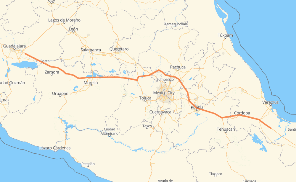
Distance between El Barrio and La Paz
The distance from El Barrio to La Paz is 554 miles by road including 550 miles on motorways. Road takes approximately 9 hours and 44 minutes and goes through Orizaba, Ixtaczoquitlán, Nogales, Cuacnopalan, Palmarito Tochapan, Acatzingo de Hidalgo and San Francisco Ocotlán (Ocotlán).
| Shortest distance by air | 473 mi ✈️ |
| Car route length | 554.3 mi 🚗 |
| Driving time | 9 h 44 min |
| Fuel amount | 18.8 gal |
| Fuel cost | 74.1 USD |
| Toll roads cost | 1,030 + ? MXN |
| Point | Distance | Time | Fuel | |
| El Barrio | 0 mi | 00 min | 0.0 gal | |
|
MEX 145D MEX 150D 71 mi, 1 h 07 min
|
||||
| Ixtaczoquitlán | 71 mi | 1 h 07 min | 2.4 gal | |
|
MEX 150D 3 mi, 03 min
|
||||
| Orizaba | 75 mi | 1 h 10 min | 2.4 gal | |
|
MEX 150D 4 mi, 05 min
|
||||
| Nogales | 79 mi | 1 h 16 min | 2.6 gal | |
|
MEX 150D 40 mi, 48 min
|
||||
| Cuacnopalan | 119 mi | 2 h 04 min | 3.9 gal | |
|
MEX 150D 8 mi, 09 min
|
||||
| Palmarito Tochapan | 127 mi | 2 h 13 min | 4.3 gal | |
|
MEX 150D 9 mi, 09 min
|
||||
| Acatzingo de Hidalgo | 136 mi | 2 h 22 min | 4.5 gal | |
|
MEX 150D 38 mi, 37 min
|
||||
| San Francisco Ocotlán (Ocotlán) | 173 mi | 3 h 00 min | 5.9 gal | |
|
MEX 150D 5 mi, 06 min
|
||||
| San Miguel Xoxtla | 178 mi | 3 h 06 min | 5.9 gal | |
|
MEX 150D MEX 15D 376 mi, 6 h 37 min
|
||||
| La Paz | 554 mi | 9 h 43 min | 18.8 gal | |
Frequently Asked Questions
How many toll booths are there from El Barrio to La Paz?
There are 14 toll booths between El Barrio and La Paz: Fortín, Cuitláhuac, Ocotlán, Zinapecuaro, Contepec, Panindicuaro, Ecuandureo, Atlacomulco — Maravatio, Atlacomulco 2, San Martin Texmelucan, San Martín, Amozoc 2, Amozoc and Esperanza 27.
How much does the toll booths cost from El Barrio to La Paz?
Toll roads cost: Cuitláhuac (114 MXN) + Fortín (33 MXN) + Esperanza 27 (140 MXN) + Amozoc (72 MXN) + Amozoc 2 (81 MXN) + San Martín (42 MXN) + San Martin Texmelucan (?) + Atlacomulco 2 (?) + Atlacomulco — Maravatio (50 MXN) + Contepec (?) + Zinapecuaro (161 MXN) + Panindicuaro (?) + Ecuandureo (111 MXN) + Ocotlán (226 MXN) = 1,030 + ? MXN
How much does it cost to drive from El Barrio to La Paz?
Fuel cost: 74.1 USD
This fuel cost is calculated as: (Route length 554.3 mi) / (Fuel consumption 29.4 mpg) * (Fuel price 3.93 USD / gal)
You can adjust fuel consumption and fuel price here.
Toll roads cost: 1,030 + ? MXN
How long is a car ride from El Barrio to La Paz?
Driving time: 9 h 44 min
This time is calculated for driving at the maximum permitted speed, taking into account traffic rules restrictions.
- 77 mi with a maximum speed 68 mph = 1 h 8 min
- 258 mi with a maximum speed 62 mph = 4 h 9 min
- 3 mi with a maximum speed 56 mph = 3 min
- 209 mi with a maximum speed 50 mph = 4 h 12 min
- 2 mi with a maximum speed 43 mph = 3 min
- 3 mi with a maximum speed 31 mph = 5 min
- 1 mi with a maximum speed 25 mph = 1 min
The calculated driving time does not take into account intermediate stops and traffic jams.
How far is El Barrio to La Paz by land?
The distance between El Barrio and La Paz is 554.3 mi by road including 549.9 mi on motorways.
Precise satellite coordinates of highways were used for this calculation. The start and finish points are the centers of El Barrio and La Paz respectively.
How far is El Barrio to La Paz by plane?
The shortest distance (air line, as the crow flies) between El Barrio and La Paz is 472.9 mi.
This distance is calculated using the Haversine formula as a great-circle distance between two points on the surface of a sphere. The start and finish points are the centers of El Barrio and La Paz respectively. Actual distance between airports may be different.
How many hours is El Barrio from La Paz by plane?
Boeing 737 airliner needs 57 min to cover the distance of 473 mi at a cruising speed of 497 mph.
Small plane "Cessna 172" needs 3 h 27 min to flight this distance at average speed of 136 mph.
This time is approximate and do not take into account takeoff and landing times, airport location and other real world factors.
How long is a helicopter ride from El Barrio to La Paz?
Fast helicopter "Eurocopter AS350" or "Hughes OH-6 Cayuse" need 3 h 10 min to cover the distance of 473 mi at a cruising speed of 149 mph.
Popular "Robinson R44" needs 3 h 37 min to flight this distance at average speed of 130 mph.
This time is approximate and do not take into account takeoff and landing times, aerodrome location and other real world factors.
What city is halfway between El Barrio and La Paz?
The halfway point between El Barrio and La Paz is Tezoquipa. It is located about 5 mi from the exact midpoint by road.
The distance from Tezoquipa to El Barrio is 272 mi and driving will take about 4 h 40 min. The road between Tezoquipa and La Paz has length 282 mi and will take approximately 5 h 3 min.
The other cities located close to halfway point:
Where is El Barrio in relation to La Paz?
El Barrio is located 473 mi south-east of La Paz.
El Barrio has geographic coordinates: latitude 18.54076, longitude -96.11059.
La Paz has geographic coordinates: latitude 20.53968, longitude -103.05138.
Which highway goes from El Barrio to La Paz?
The route from El Barrio to La Paz follows MEX 15D, MEX 150D, MEX M40D.
Other minor sections pass along the road:
- MEX 145D: 29 mi
- MEX 040D: 4 mi
- MEX 140D: 1 mi