Distance between El Desengaño and Planta de Aguamonia
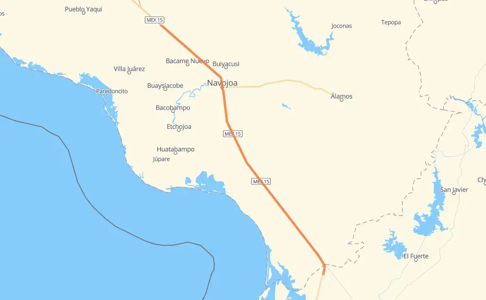
The distance from El Desengaño to Planta de Aguamonia is 81 miles by road including 70 miles on motorways. Road takes approximately 1 hour and 34 minutes and goes through Navojoa, Estacion Fitopecuaria, El Desengaño, Emiliano Zapata Uno, Emiliano Zapata Dos, Ejido Manuel Caudillo and Ejido 24 de Febrero.
| Shortest distance by air | 78 mi ✈️ |
| Car route length | 80.8 mi 🚗 |
| Driving time | 1 h 34 min |
| Fuel amount | 2.8 gal |
| Fuel cost | 10.8 USD |
| Toll roads cost | 90 MXN |
| Point | Distance | Time | Fuel | |
| El Desengaño | 0 mi | 00 min | 0.0 gal | |
|
MEX 15D 2 mi, 02 min
|
||||
| Estacion Fitopecuaria | 2 mi | 02 min | 0.0 gal | |
|
MEX 15D 2 mi, 03 min
|
||||
| Emiliano Zapata Uno | 5 mi | 05 min | 0.1 gal | |
|
MEX 15D 4 mi, 04 min
|
||||
| Emiliano Zapata Dos | 9 mi | 09 min | 0.3 gal | |
|
MEX 15D 4 mi, 04 min
|
||||
| Ejido 24 de Febrero | 12 mi | 14 min | 0.3 gal | |
|
MEX 15D 4 mi, 04 min
|
||||
| Lucio Blanco | 16 mi | 18 min | 0.5 gal | |
|
MEX 15D 2 mi, 02 min
|
||||
| Diez de Abril | 18 mi | 21 min | 0.6 gal | |
|
MEX 15D 2 mi, 02 min
|
||||
| Cafe Lupita (Luchy) | 21 mi | 23 min | 0.7 gal | |
|
MEX 15D 6 mi, 06 min
|
||||
| Guadalupe Estrella (Kilometro 107) | 27 mi | 30 min | 0.9 gal | |
|
MEX 15D 30 mi, 35 min
|
||||
| Navojoa | 57 mi | 1 h 06 min | 1.8 gal | |
|
MEX 15D 24 mi, 28 min
|
||||
| 27.30816, -109.70155 | 81 mi | 1 h 34 min | 2.8 gal | |
Frequently Asked Questions
How many toll booths are there from El Desengaño to Planta de Aguamonia?
There are 1 tollbooth between El Desengaño and Planta de Aguamonia: Estacion Don La Jaula.
How much does the toll booths cost from El Desengaño to Planta de Aguamonia?
Toll roads cost: Estacion Don La Jaula (90 MXN) = 90 MXN
How much does it cost to drive from El Desengaño to Planta de Aguamonia?
Fuel cost: 10.8 USD
This fuel cost is calculated as: (Route length 80.8 mi) / (Fuel consumption 29.4 mpg) * (Fuel price 3.93 USD / gal)
You can adjust fuel consumption and fuel price here.
Toll roads cost: 90 MXN
How long is a car ride from El Desengaño to Planta de Aguamonia?
Driving time: 1 h 34 min
This time is calculated for driving at the maximum permitted speed, taking into account traffic rules restrictions.
- 19 mi with a maximum speed 62 mph = 18 min
- 2 mi with a maximum speed 56 mph = 2 min
- 57 mi with a maximum speed 50 mph = 1 h 8 min
- 2 mi with a maximum speed 31 mph = 4 min
The calculated driving time does not take into account intermediate stops and traffic jams.
How far is El Desengaño to Planta de Aguamonia by land?
The distance between El Desengaño and Planta de Aguamonia is 80.8 mi by road including 70.2 mi on motorways.
Precise satellite coordinates of highways were used for this calculation. The start and finish points are the centers of El Desengaño and Planta de Aguamonia respectively.
How far is El Desengaño to Planta de Aguamonia by plane?
The shortest distance (air line, as the crow flies) between El Desengaño and Planta de Aguamonia is 77.7 mi.
This distance is calculated using the Haversine formula as a great-circle distance between two points on the surface of a sphere. The start and finish points are the centers of El Desengaño and Planta de Aguamonia respectively. Actual distance between airports may be different.
How many hours is El Desengaño from Planta de Aguamonia by plane?
Boeing 737 airliner needs 9 min to cover the distance of 78 mi at a cruising speed of 497 mph.
Small plane "Cessna 172" needs 34 min to flight this distance at average speed of 136 mph.
This time is approximate and do not take into account takeoff and landing times, airport location and other real world factors.
How long is a helicopter ride from El Desengaño to Planta de Aguamonia?
Fast helicopter "Eurocopter AS350" or "Hughes OH-6 Cayuse" need 31 min to cover the distance of 78 mi at a cruising speed of 149 mph.
Popular "Robinson R44" needs 35 min to flight this distance at average speed of 130 mph.
This time is approximate and do not take into account takeoff and landing times, aerodrome location and other real world factors.
What city is halfway between El Desengaño and Planta de Aguamonia?
The halfway point between El Desengaño and Planta de Aguamonia is El Crucero. It is located about 3 mi from the exact midpoint by road.
The distance from El Crucero to El Desengaño is 38 mi and driving will take about 42 min. The road between El Crucero and Planta de Aguamonia has length 43 mi and will take approximately 51 min.
The other cities located close to halfway point:
Where is El Desengaño in relation to Planta de Aguamonia?
El Desengaño is located 78 mi south-east of Planta de Aguamonia.
El Desengaño has geographic coordinates: latitude 26.361, longitude -109.01476.
Planta de Aguamonia has geographic coordinates: latitude 27.30816, longitude -109.70155.
Which highway goes from El Desengaño to Planta de Aguamonia?
The route from El Desengaño to Planta de Aguamonia follows MEX 15D.