Distance between El Mimbre and Agua Prieta
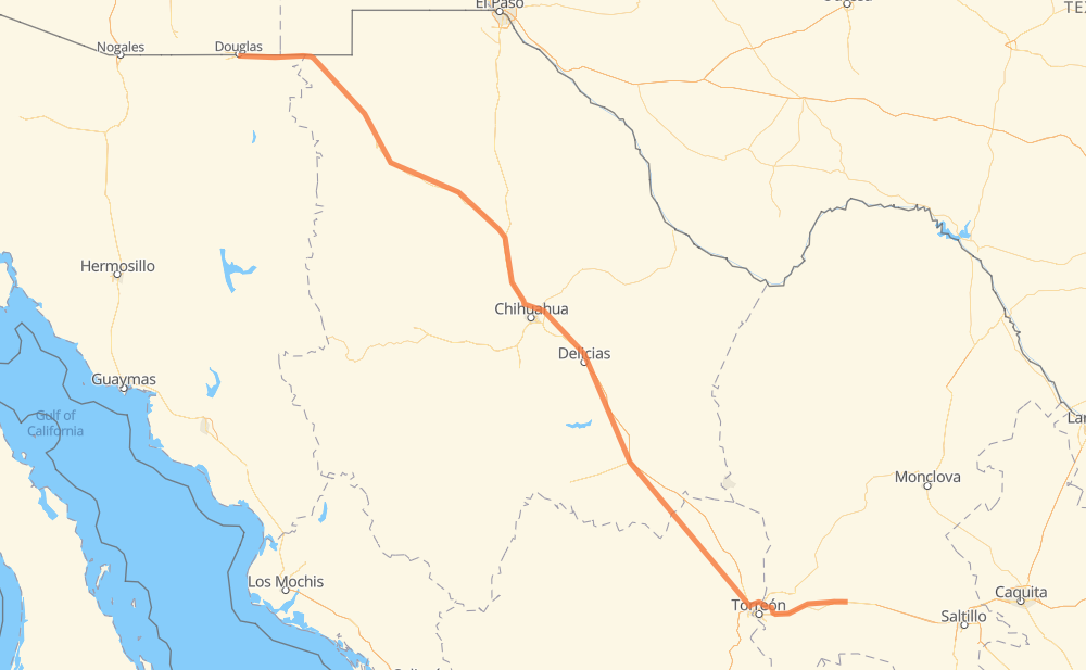
The distance from El Mimbre to Agua Prieta is 682 miles by road including 219 miles on motorways. Road takes approximately 12 hours and 6 minutes and goes through Jiménez, Camargo, Delicias and Nuevo Casas Grandes.
| Shortest distance by air | 586 mi ✈️ |
| Car route length | 682.3 mi 🚗 |
| Driving time | 12 h 6 min |
| Fuel amount | 23.2 gal |
| Fuel cost | 91.2 USD |
| Toll roads cost | 1,014 + ? MXN |
| Point | Distance | Time | Fuel | |
| El Mimbre | 0 mi | 00 min | 0.0 gal | |
|
MEX 40 MEX 40D 110 mi, 1 h 55 min
|
||||
| Bermejillo | 110 mi | 1 h 55 min | 3.2 gal | |
|
MEX 49D 128 mi, 2 h 05 min
|
||||
| Jiménez | 238 mi | 4 h 00 min | 7.4 gal | |
|
MEX 45D 27 mi, 28 min
|
||||
| Camargo | 265 mi | 4 h 29 min | 8.9 gal | |
|
MEX 45 MEX 45D 21 mi, 19 min
|
||||
| Conchos | 286 mi | 4 h 48 min | 9.6 gal | |
|
MEX 45D 6 mi, 05 min
|
||||
| Estación Saucillo | 292 mi | 4 h 54 min | 9.8 gal | |
|
MEX 45D 16 mi, 17 min
|
||||
| Delicias | 308 mi | 5 h 11 min | 10.3 gal | |
|
MEX 45 14 mi, 15 min
|
||||
| Lazaro Cardenas | 322 mi | 5 h 27 min | 10.8 gal | |
|
MEX 45 223 mi, 4 h 03 min
|
||||
| Nuevo Casas Grandes | 545 mi | 9 h 30 min | 18.4 gal | |
|
MEX 10 MEX 2 137 mi, 2 h 35 min
|
||||
| Agua Prieta | 682 mi | 12 h 06 min | 23.2 gal | |
Hotels of Agua Prieta
Frequently Asked Questions
How many toll booths are there from El Mimbre to Agua Prieta?
There are 13 toll booths between El Mimbre and Agua Prieta: Galeana, Ojo Laguna, Sacramento, Libramiento Oriente de Chihuahua - Sacramento, Libramiento Oriente de Chihuahua - Jimenez, Saucillo, Camargo, Jimenez, Savalza, La Cuchilla, San Pedro km 16+830, Ceballos and Bermejillo.
How much does the toll booths cost from El Mimbre to Agua Prieta?
Toll roads cost: La Cuchilla (79 MXN) + San Pedro km 16+830 (?) + Bermejillo (127 MXN) + Ceballos (145 MXN) + Savalza (71 MXN) + Jimenez (97 MXN) + Camargo (71 MXN) + Saucillo (71 MXN) + Libramiento Oriente de Chihuahua - Jimenez (35 MXN) + Libramiento Oriente de Chihuahua - Sacramento (36 MXN) + Sacramento (71 MXN) + Ojo Laguna (96 MXN) + Galeana (115 MXN) = 1,014 + ? MXN
How much does it cost to drive from El Mimbre to Agua Prieta?
Fuel cost: 91.2 USD
This fuel cost is calculated as: (Route length 682.3 mi) / (Fuel consumption 29.4 mpg) * (Fuel price 3.93 USD / gal)
You can adjust fuel consumption and fuel price here.
Toll roads cost: 1,014 + ? MXN
How long is a car ride from El Mimbre to Agua Prieta?
Driving time: 12 h 6 min
This time is calculated for driving at the maximum permitted speed, taking into account traffic rules restrictions.
- 45 mi with a maximum speed 68 mph = 39 min
- 165 mi with a maximum speed 62 mph = 2 h 39 min
- 129 mi with a maximum speed 56 mph = 2 h 18 min
- 251 mi with a maximum speed 56 mph = 4 h 29 min
- 79 mi with a maximum speed 50 mph = 1 h 35 min
- 11 mi with a maximum speed 37 mph = 16 min
- 2 mi with a maximum speed 31 mph = 3 min
- 1 mi with a maximum speed 25 mph = 1 min
The calculated driving time does not take into account intermediate stops and traffic jams.
How far is El Mimbre to Agua Prieta by land?
The distance between El Mimbre and Agua Prieta is 682.3 mi by road including 218.7 mi on motorways.
Precise satellite coordinates of highways were used for this calculation. The start and finish points are the centers of El Mimbre and Agua Prieta respectively.
How far is El Mimbre to Agua Prieta by plane?
The shortest distance (air line, as the crow flies) between El Mimbre and Agua Prieta is 586 mi.
This distance is calculated using the Haversine formula as a great-circle distance between two points on the surface of a sphere. The start and finish points are the centers of El Mimbre and Agua Prieta respectively. Actual distance between airports may be different.
How many hours is El Mimbre from Agua Prieta by plane?
Boeing 737 airliner needs 1 h 10 min to cover the distance of 586 mi at a cruising speed of 497 mph.
Small plane "Cessna 172" needs 4 h 17 min to flight this distance at average speed of 136 mph.
This time is approximate and do not take into account takeoff and landing times, airport location and other real world factors.
How long is a helicopter ride from El Mimbre to Agua Prieta?
Fast helicopter "Eurocopter AS350" or "Hughes OH-6 Cayuse" need 3 h 55 min to cover the distance of 586 mi at a cruising speed of 149 mph.
Popular "Robinson R44" needs 4 h 29 min to flight this distance at average speed of 130 mph.
This time is approximate and do not take into account takeoff and landing times, aerodrome location and other real world factors.
What city is halfway between El Mimbre and Agua Prieta?
The halfway point between El Mimbre and Agua Prieta is Tomas Garcia.
The distance from Tomas Garcia to El Mimbre is 341 mi and driving will take about 5 h 47 min. The road between Tomas Garcia and Agua Prieta has length 341 mi and will take approximately 6 h 18 min.
The other cities located close to halfway point:
Where is El Mimbre in relation to Agua Prieta?
El Mimbre is located 586 mi south-east of Agua Prieta.
El Mimbre has geographic coordinates: latitude 25.66944, longitude -102.36013.
Agua Prieta has geographic coordinates: latitude 31.32459, longitude -109.54913.
Which highway goes from El Mimbre to Agua Prieta?
The route from El Mimbre to Agua Prieta follows MEX 49D, MEX 45D, MEX 2, MEX 45, MEX 10.
Other minor sections pass along the road:
- CHIH 7: 47 mi
- MEX 40D: 47 mi
- CHIH 56D: 38 mi
- MEX 40: 32 mi
- MEX 49: 22 mi
- CHIH 4: 1 mi