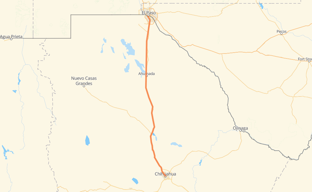
Distance between El Paso TX and Chihuahua
The distance from El Paso to Chihuahua is 229 miles by road. Road takes approximately 4 hours and 9 minutes and goes through Ciudad Juárez, Villa Ahumada, Samalayuca, San Lorencito, Ejido Rancho Ojo Laguna, Ejido Nuevo Delicias y Anexas (Tierras Nuevas) and San Isidro (Los Hoyos).
| Shortest distance by air | 216 mi ✈️ |
| Car route length | 228.7 mi 🚗 |
| Driving time | 4 h 9 min |
| Fuel amount | 7.8 gal |
| Fuel cost | 30.6 USD |
| Toll roads cost | 259 MXN |
| Point | Distance | Time | Fuel | |
| El Paso | 0 mi | 00 min | 0.0 gal | |
|
US 85 9 mi, 09 min
|
||||
| Ciudad Juárez | 9 mi | 09 min | 0.2 gal | |
|
MEX 45 27 mi, 29 min
|
||||
| El Lobo | 35 mi | 39 min | 1.0 gal | |
|
MEX 45 45 mi, 49 min
|
||||
| Villa Ahumada | 81 mi | 1 h 28 min | 2.6 gal | |
|
MEX 45 MEX 45D 88 mi, 1 h 34 min
|
||||
| Ejido Rancho Ojo Laguna | 168 mi | 3 h 03 min | 5.7 gal | |
|
MEX 45 16 mi, 16 min
|
||||
| Ejido Nuevo Delicias y Anexas (Tierras Nuevas) | 184 mi | 3 h 20 min | 6.2 gal | |
|
MEX 45 25 mi, 26 min
|
||||
| San Isidro (Los Hoyos) | 209 mi | 3 h 47 min | 7.0 gal | |
|
MEX 45 3 mi, 03 min
|
||||
| Colonia Sacramento | 212 mi | 3 h 50 min | 7.2 gal | |
|
MEX 45D 3 mi, 03 min
|
||||
| Ejido Nuevo Sacramento | 214 mi | 3 h 53 min | 7.2 gal | |
|
MEX 45D MEX 45 14 mi, 16 min
|
||||
| Chihuahua | 229 mi | 4 h 09 min | 7.7 gal | |
Hotels of Chihuahua
Frequently Asked Questions
How many toll booths are there from El Paso to Chihuahua?
There are 2 toll booths between El Paso and Chihuahua: Villa Ahumada and Sacramento.
How much does the toll booths cost from El Paso to Chihuahua?
Toll roads cost: Villa Ahumada (188 MXN) + Sacramento (71 MXN) = 259 MXN
How much does it cost to drive from El Paso to Chihuahua?
Fuel cost: 30.6 USD
This fuel cost is calculated as: (Route length 228.7 mi) / (Fuel consumption 29.4 mpg) * (Fuel price 3.93 USD / gal)
You can adjust fuel consumption and fuel price here.
Toll roads cost: 259 MXN
How long is a car ride from El Paso to Chihuahua?
Driving time: 4 h 9 min
This time is calculated for driving at the maximum permitted speed, taking into account traffic rules restrictions.
- 136 mi with a maximum speed 56 mph = 2 h 26 min
- 78 mi with a maximum speed 56 mph = 1 h 23 min
- 10 mi with a maximum speed 50 mph = 12 min
- 2 mi with a maximum speed 43 mph = 3 min
- 1 mi with a maximum speed 31 mph = 2 min
- 1 mi with a maximum speed 25 mph = 1 min
The calculated driving time does not take into account intermediate stops and traffic jams.
How far is El Paso to Chihuahua by land?
The distance between El Paso and Chihuahua is 228.7 mi by road.
Precise satellite coordinates of highways were used for this calculation. The start and finish points are the centers of El Paso and Chihuahua respectively.
How far is El Paso to Chihuahua by plane?
The shortest distance (air line, as the crow flies) between El Paso and Chihuahua is 215.6 mi.
This distance is calculated using the Haversine formula as a great-circle distance between two points on the surface of a sphere. The start and finish points are the centers of El Paso and Chihuahua respectively. Actual distance between airports may be different.
How many hours is El Paso from Chihuahua by plane?
Boeing 737 airliner needs 26 min to cover the distance of 216 mi at a cruising speed of 497 mph.
Small plane "Cessna 172" needs 1 h 34 min to flight this distance at average speed of 136 mph.
This time is approximate and do not take into account takeoff and landing times, airport location and other real world factors.
How long is a helicopter ride from El Paso to Chihuahua?
Fast helicopter "Eurocopter AS350" or "Hughes OH-6 Cayuse" need 1 h 26 min to cover the distance of 216 mi at a cruising speed of 149 mph.
Popular "Robinson R44" needs 1 h 39 min to flight this distance at average speed of 130 mph.
This time is approximate and do not take into account takeoff and landing times, aerodrome location and other real world factors.
What city is halfway between El Paso and Chihuahua?
The halfway point between El Paso and Chihuahua is Antiguo Paradero Moctezuma. It is located about 1 mi from the exact midpoint by road.
The distance from Antiguo Paradero Moctezuma to El Paso is 116 mi and driving will take about 2 h 7 min. The road between Antiguo Paradero Moctezuma and Chihuahua has length 113 mi and will take approximately 2 h 2 min.
The other cities located close to halfway point:
Where is El Paso in relation to Chihuahua?
El Paso is located 216 mi north of Chihuahua.
El Paso has geographic coordinates: latitude 31.76004, longitude -106.48729.
Chihuahua has geographic coordinates: latitude 28.66057, longitude -106.07498.
Which highway goes from El Paso to Chihuahua?
The route from El Paso to Chihuahua follows MEX 45.
Other minor sections pass along the road:
- MEX 45D: 60 mi