Distance between Esperanza and Victoria
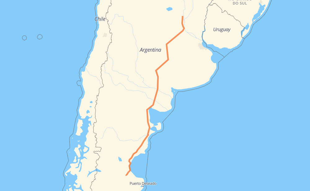
The distance from Esperanza to Victoria is 1,347 miles by road including 83 miles on motorways. Road takes approximately 24 hours and 40 minutes and goes through Comodoro Rivadavia, Caleta Olivia, San Eduardo, San Lorenzo, Roldán, Santa Teresa and Casilda.
| Shortest distance by air | 1,129 mi ✈️ |
| Car route length | 1,346.5 mi 🚗 |
| Driving time | 24 h 40 min |
| Fuel amount | 45.8 gal |
| Fuel cost | 180 USD |
| Point | Distance | Time | Fuel | |
| Esperanza | 0 mi | 00 min | 0.0 gal | |
|
RP6 AP01 107 mi, 1 h 39 min
|
||||
| San Eduardo | 107 mi | 1 h 39 min | 3.6 gal | |
|
RNA012 14 mi, 17 min
|
||||
| Roldán | 121 mi | 1 h 57 min | 4.1 gal | |
|
RNA012 RN33 24 mi, 28 min
|
||||
| Casilda | 145 mi | 2 h 25 min | 4.9 gal | |
|
RN33 34 mi, 43 min
|
||||
| Firmat | 179 mi | 3 h 08 min | 6.0 gal | |
|
RN33 31 mi, 36 min
|
||||
| Cumelén | 210 mi | 3 h 45 min | 7.1 gal | |
|
RN33 32 mi, 36 min
|
||||
| Sancti Spíritu | 242 mi | 4 h 22 min | 7.8 gal | |
|
RN33 35 mi, 39 min
|
||||
| Colonia Dolores | 277 mi | 5 h 01 min | 9.3 gal | |
|
RN33 RN3 979 mi, 17 h 48 min
|
||||
| Comodoro Rivadavia | 1,257 mi | 22 h 50 min | 42.7 gal | |
|
RN3 89 mi, 1 h 49 min
|
||||
| Victoria | 1,347 mi | 24 h 40 min | 45.6 gal | |
Frequently Asked Questions
How much does it cost to drive from Esperanza to Victoria?
Fuel cost: 180 USD
This fuel cost is calculated as: (Route length 1,346.5 mi) / (Fuel consumption 29.4 mpg) * (Fuel price 3.93 USD / gal)
You can adjust fuel consumption and fuel price here.
How long is a car ride from Esperanza to Victoria?
Driving time: 24 h 40 min
This time is calculated for driving at the maximum permitted speed, taking into account traffic rules restrictions.
- 81 mi with a maximum speed 68 mph = 1 h 12 min
- 1 mi with a maximum speed 62 mph = 1 min
- 1,134 mi with a maximum speed 56 mph = 20 h 14 min
- 64 mi with a maximum speed 50 mph = 1 h 17 min
- 58 mi with a maximum speed 37 mph = 1 h 32 min
- 1 mi with a maximum speed 31 mph = 2 min
- 5 mi with a maximum speed 25 mph = 12 min
- 1 mi with a maximum speed 12 mph = 6 min
The calculated driving time does not take into account intermediate stops and traffic jams.
How far is Esperanza to Victoria by land?
The distance between Esperanza and Victoria is 1,346.5 mi by road including 83.3 mi on motorways.
Precise satellite coordinates of highways were used for this calculation. The start and finish points are the centers of Esperanza and Victoria respectively.
How far is Esperanza to Victoria by plane?
The shortest distance (air line, as the crow flies) between Esperanza and Victoria is 1,129 mi.
This distance is calculated using the Haversine formula as a great-circle distance between two points on the surface of a sphere. The start and finish points are the centers of Esperanza and Victoria respectively. Actual distance between airports may be different.
How many hours is Esperanza from Victoria by plane?
Boeing 737 airliner needs 2 h 16 min to cover the distance of 1,129 mi at a cruising speed of 497 mph.
Small plane "Cessna 172" needs 8 h 15 min to flight this distance at average speed of 136 mph.
This time is approximate and do not take into account takeoff and landing times, airport location and other real world factors.
How long is a helicopter ride from Esperanza to Victoria?
Fast helicopter "Eurocopter AS350" or "Hughes OH-6 Cayuse" need 7 h 34 min to cover the distance of 1,129 mi at a cruising speed of 149 mph.
Popular "Robinson R44" needs 8 h 39 min to flight this distance at average speed of 130 mph.
This time is approximate and do not take into account takeoff and landing times, aerodrome location and other real world factors.
What city is halfway between Esperanza and Victoria?
The halfway point between Esperanza and Victoria is Río Colorado. It is located about 11 mi from the exact midpoint by road.
The distance from Río Colorado to Esperanza is 684 mi and driving will take about 12 h 26 min. The road between Río Colorado and Victoria has length 663 mi and will take approximately 12 h 13 min.
The other cities located close to halfway point:
Where is Esperanza in relation to Victoria?
Esperanza is located 1,129 mi north-east of Victoria.
Esperanza has geographic coordinates: latitude -31.44885, longitude -60.92997.
Victoria has geographic coordinates: latitude -46.8445, longitude -68.0566.
Which highway goes from Esperanza to Victoria?
The route from Esperanza to Victoria follows RN3, RN33, RN251, RN154, AP01, RN5.
Other minor sections pass along the road:
- RN35: 49 mi
- RP1: 43 mi
- RP12: 36 mi
- RP18: 34 mi
- RNA012: 22 mi
- RN22: 20 mi
- RP6: 13 mi
- RN19: 9 mi
- RP43: 2 mi