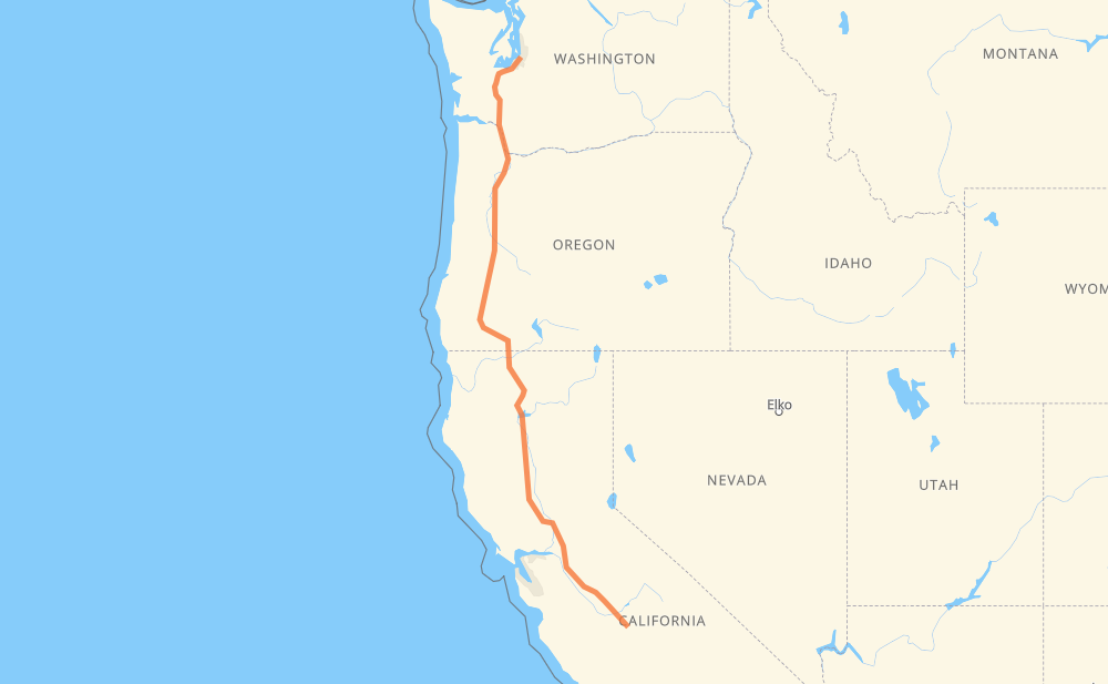
The distance from Federal Way to Selma is 916 miles by road including 912 miles on motorways. Road takes approximately 14 hours and 12 minutes and goes through Tacoma, Olympia, Vancouver, Portland, Salem, Medford and Redding.
You can adjust fuel consumption and fuel price here.
How long is a car ride from Federal Way to Selma?
Driving time:
14 h 12 min
This time is calculated for driving at the maximum permitted speed, taking into account traffic rules restrictions.
272 mi with a maximum speed 68 mph = 4 h
522 mi with a maximum speed 65 mph = 8 h 1 min
74 mi with a maximum speed 60 mph = 1 h 13 min
29 mi with a maximum speed 55 mph = 30 min
9 mi with a maximum speed 50 mph = 10 min
8 mi with a maximum speed 50 mph = 9 min
2 mi with a maximum speed 35 mph = 3 min
1 mi with a maximum speed 25 mph = 1 min
The calculated driving time does not take into account intermediate stops and traffic jams.
How far is Federal Way to Selma by land?
The distance between Federal Way and Selma is 915.9 mi by road including 911.6 mi on motorways.
Precise satellite coordinates of highways were used for this calculation. The start and finish points are the centers of Federal Way and Selma respectively.
How far is Federal Way to Selma by plane?
The shortest distance (air line, as the crow flies) between Federal Way and Selma is 755.6 mi.
This distance is calculated using the Haversine formula as a great-circle distance between two points on the surface of a sphere. The start and finish points are the centers of Federal Way and Selma respectively. Actual distance between airports may be different.
How many hours is Federal Way from Selma by plane?
Boeing 737 airliner needs 1 h 31 min to cover the distance of 756 mi at a cruising speed of 497 mph.
Small plane "Cessna 172" needs 5 h 31 min to flight this distance at average speed of 136 mph.
This time is approximate and do not take into account takeoff and landing times, airport location and other real world factors.
How long is a helicopter ride from Federal Way to Selma?
Fast helicopter "Eurocopter AS350" or "Hughes OH-6 Cayuse" need 5 h 4 min to cover the distance of 756 mi at a cruising speed of 149 mph.
Popular "Robinson R44" needs 5 h 47 min to flight this distance at average speed of 130 mph.
This time is approximate and do not take into account takeoff and landing times, aerodrome location and other real world factors.
What city is halfway between Federal Way and Selma?
The halfway point between Federal Way and Selma is Yreka. It is located about 16 mi from the exact midpoint by road.
The distance from Yreka to Federal Way is 474 mi and driving will take about 7 h 28 min. The road between Yreka and Selma has length 442 mi and will take approximately 6 h 43 min.
The other cities located close to halfway point:
Ashland is in 438 mi from Federal Way and 478 mi from Selma
Medford is in 424 mi from Federal Way and 492 mi from Selma
Weed is in 501 mi from Federal Way and 414 mi from Selma
Where is Federal Way in relation to Selma?
Federal Way is located 756 mi north of Selma.
Federal Way has geographic coordinates: latitude 47.31349, longitude -122.33931.
Selma has geographic coordinates: latitude 36.57078, longitude -119.61208.
Which highway goes from Federal Way to Selma?
The route from Federal Way to Selma follows I 5, CA 99, OR 99.