Distance between Geeveston and Leinster

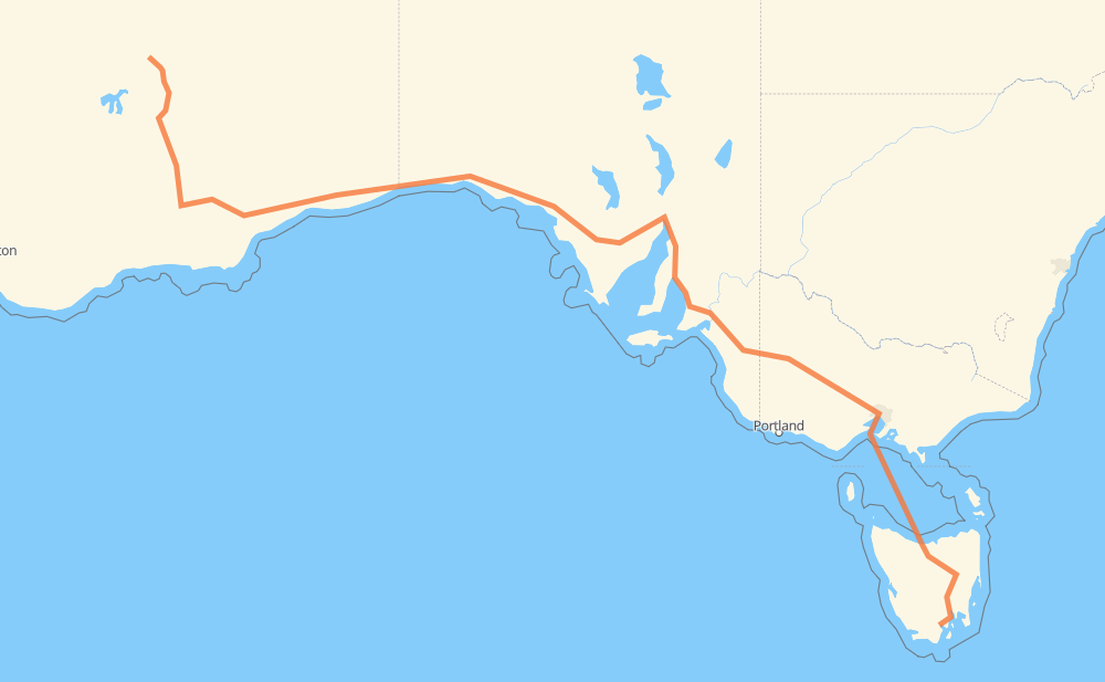
The distance from Geeveston to Leinster is 2,502 miles by road including 181 miles on motorways. Road takes approximately 61 hours and 56 minutes and goes through Hobart, Devonport, Horsham, Murray Bridge, Adelaide, Port Augusta and Kalgoorlie.

There are ferries on the route.
Shortest distance by air 1,800 mi ✈️
Car route length 2,502.3 mi 🚗
Driving time 61 h 56 min
Fuel amount 85.1 gal
Fuel cost 331.9 USD
Click here to load the interactive map
Compare this route in other services:
City
Town
Village
Hamlet
Motorway
Primary
Secondary
Unclassified
Point Distance Time Fuel
Geeveston 0 mi 0:00 00 min 0.0 gal
A6 37 mi, 45 min
Hobart 37 mi 0:45 45 min 1.2 gal
1 6 mi, 07 min
Montrose 43 mi 0:52 52 min 1.4 gal
1 168 mi, 3 h 02 min
Devonport 211 mi 3:54 3 h 54 min 7.2 gal
M8 463 mi, 25 h 03 min
Horsham 674 mi 28:58 28 h 58 min 22.6 gal
A8 211 mi, 3 h 53 min
Murray Bridge 885 mi 32:51 32 h 51 min 30.0 gal
A1 M1 45 mi, 43 min
Adelaide 930 mi 33:34 33 h 34 min 31.6 gal
R1 A1 191 mi, 3 h 28 min
Port Augusta 1,122 mi 37:03 37 h 03 min 38.1 gal
A1 1,151 mi, 20 h 41 min
Kalgoorlie 2,272 mi 57:44 57 h 44 min 77.2 gal
94 230 mi, 4 h 12 min
Leinster 2,502 mi 61:56 61 h 56 min 84.4 gal
City
Town
Village
Hamlet
Motorway
Primary
Secondary
Unclassified
Point Distance Time Fuel
Geeveston 0 mi 0:00 00 min 0.0 gal
A6 4 mi, 05 min
Castle Forbes Bay 4 mi 0:05 05 min 0.1 gal
A6 4 mi, 03 min
South Franklin 7 mi 0:09 09 min 0.2 gal
A6 1 mi, 01 min
Franklin 9 mi 0:11 11 min 0.3 gal
A6 9 mi, 11 min
Grove 18 mi 0:23 23 min 0.6 gal
A6 6 mi, 06 min
Sandfly 24 mi 0:29 29 min 0.8 gal
A6 14 mi, 15 min
Hobart 37 mi 0:45 45 min 1.2 gal
1 6 mi, 07 min
Montrose 43 mi 0:52 52 min 1.4 gal
1 10 mi, 10 min
Brighton 53 mi 1:03 1 h 03 min 1.8 gal
1 5 mi, 04 min
Mangalore 58 mi 1:07 1 h 07 min 1.9 gal
1 3 mi, 03 min
Bagdad 61 mi 1:11 1 h 11 min 2.0 gal
1 2 mi, 03 min
Dysart 63 mi 1:14 1 h 14 min 2.1 gal
1 5 mi, 05 min
Kempton 69 mi 1:20 1 h 20 min 2.3 gal
1 2 mi, 02 min
Melton Mowbray 71 mi 1:22 1 h 22 min 2.4 gal
1 21 mi, 22 min
Oatlands 93 mi 1:45 1 h 45 min 2.8 gal
1 12 mi, 12 min
Tunbridge 104 mi 1:58 1 h 58 min 3.5 gal
1 8 mi, 08 min
Ross 112 mi 2:06 2 h 06 min 3.7 gal
1 7 mi, 07 min
Campbell Town 119 mi 2:14 2 h 14 min 3.9 gal
1 11 mi, 12 min
Cleveland 130 mi 2:26 2 h 26 min 4.4 gal
1 6 mi, 06 min
Epping Forest 135 mi 2:32 2 h 32 min 4.4 gal
1 14 mi, 16 min
Perth 150 mi 2:48 2 h 48 min 5.1 gal
1 4 mi, 05 min
Longford 154 mi 2:53 2 h 53 min 5.1 gal
B52 6 mi, 06 min
Carrick 160 mi 2:59 2 h 59 min 5.4 gal
1 10 mi, 10 min
Westbury 170 mi 3:10 3 h 10 min 5.7 gal
1 7 mi, 08 min
Deloraine 177 mi 3:18 3 h 18 min 5.9 gal
1 9 mi, 09 min
Elizabeth Town 186 mi 3:27 3 h 27 min 6.3 gal
1 14 mi, 14 min
Sassafras 199 mi 3:42 3 h 42 min 6.7 gal
1 6 mi, 06 min
Latrobe 205 mi 3:48 3 h 48 min 6.9 gal
1 6 mi, 05 min
Devonport 211 mi 3:54 3 h 54 min 7.2 gal
137 mi, 10 h 56 min
Port Melbourne 348 mi 14:51 14 h 51 min 7.2 gal
M1 138 mi, 10 h 57 min
Spotswood 486 mi 25:48 25 h 48 min 16.5 gal
M1 2 mi, 01 min
Altona North 488 mi 25:50 25 h 50 min 16.6 gal
M1 2 mi, 01 min
Laverton North 490 mi 25:52 25 h 52 min 16.7 gal
M80 2 mi, 02 min
Derrimut 493 mi 25:54 25 h 54 min 16.7 gal
M8 4 mi, 03 min
Ravenhall 496 mi 25:58 25 h 58 min 16.8 gal
M8 6 mi, 05 min
Rockbank 502 mi 26:03 26 h 03 min 17.0 gal
M8 5 mi, 04 min
Melton South 507 mi 26:08 26 h 08 min 17.2 gal
M8 2 mi, 02 min
Brookfield 510 mi 26:10 26 h 10 min 17.3 gal
M8 2 mi, 01 min
Hopetoun Park 512 mi 26:12 26 h 12 min 17.4 gal
M8 4 mi, 03 min
Bacchus Marsh 516 mi 26:16 26 h 16 min 17.4 gal
M8 5 mi, 04 min
Pentland Hills 521 mi 26:20 26 h 20 min 17.7 gal
M8 3 mi, 02 min
Myrniong 524 mi 26:22 26 h 22 min 17.8 gal
M8 8 mi, 07 min
Ballan 532 mi 26:30 26 h 30 min 17.9 gal
M8 14 mi, 12 min
Leigh Creek 546 mi 26:42 26 h 42 min 18.6 gal
M8 3 mi, 03 min
Brown Hill 549 mi 26:46 26 h 46 min 18.6 gal
M8 2 mi, 02 min
Invermay Park 552 mi 26:48 26 h 48 min 18.7 gal
M8 2 mi, 01 min
Wendouree 553 mi 26:49 26 h 49 min 18.8 gal
M8 3 mi, 02 min
Mitchell Park 557 mi 26:52 26 h 52 min 18.8 gal
M8 52 mi, 50 min
Ararat 608 mi 27:43 27 h 43 min 20.5 gal
A8 11 mi, 12 min
Great Western 618 mi 27:55 27 h 55 min 21.0 gal
A8 7 mi, 08 min
Stawell 626 mi 28:04 28 h 04 min 21.2 gal
A8 16 mi, 17 min
Dadswells Bridge 641 mi 28:21 28 h 21 min 21.7 gal
A8 32 mi, 35 min
Horsham 674 mi 28:57 28 h 57 min 22.6 gal
A8 21 mi, 23 min
Dimboola 695 mi 29:20 29 h 20 min 23.2 gal
A8 27 mi, 29 min
Nhill 721 mi 29:50 29 h 50 min 24.0 gal
A8 18 mi, 20 min
Kaniva 739 mi 30:10 30 h 10 min 25.0 gal
A8 4 mi, 04 min
Lillimur 743 mi 30:14 30 h 14 min 25.3 gal
A8 20 mi, 21 min
Bordertown 763 mi 30:36 30 h 36 min 25.7 gal
A8 13 mi, 14 min
Wirrega 777 mi 30:51 30 h 51 min 26.2 gal
A8 18 mi, 19 min
Keith 794 mi 31:11 31 h 11 min 26.6 gal
A8 20 mi, 21 min
Tintinara 814 mi 31:32 31 h 32 min 27.4 gal
A8 9 mi, 09 min
Culburra 823 mi 31:42 31 h 42 min 28.0 gal
A8 11 mi, 11 min
Coonalpyn 833 mi 31:54 31 h 54 min 28.1 gal
A8 9 mi, 09 min
Ki Ki 842 mi 32:03 32 h 03 min 28.6 gal
A8 5 mi, 05 min
Yumali 847 mi 32:09 32 h 09 min 28.8 gal
A8 4 mi, 04 min
Coomandook 851 mi 32:13 32 h 13 min 28.9 gal
A8 22 mi, 23 min
Tailem Bend 872 mi 32:37 32 h 37 min 29.4 gal
A1 12 mi, 13 min
Murray Bridge 885 mi 32:50 32 h 50 min 30.0 gal
A1 M1 24 mi, 20 min
Littlehampton 908 mi 33:11 33 h 11 min 30.8 gal
M1 6 mi, 05 min
Hahndorf 915 mi 33:16 33 h 16 min 31.0 gal
M1 4 mi, 03 min
Bridgewater 919 mi 33:20 33 h 20 min 31.2 gal
M1 3 mi, 02 min
Stirling 922 mi 33:23 33 h 23 min 31.3 gal
M1 1 mi, 00 min
Crafers 923 mi 33:24 33 h 24 min 31.4 gal
M1 6 mi, 06 min
Glen Osmond 928 mi 33:30 33 h 30 min 31.6 gal
A1 2 mi, 03 min
Adelaide 930 mi 33:33 33 h 33 min 31.6 gal
R1 2 mi, 03 min
North Adelaide 933 mi 33:37 33 h 37 min 31.7 gal
R1 M2 14 mi, 15 min
Waterloo Corner 946 mi 33:53 33 h 53 min 32.1 gal
M2 6 mi, 05 min
Virginia 953 mi 33:59 33 h 59 min 32.3 gal
A1 5 mi, 05 min
Two Wells 958 mi 34:04 34 h 04 min 32.5 gal
A1 6 mi, 06 min
Lower Light 963 mi 34:10 34 h 10 min 32.8 gal
A1 5 mi, 05 min
Dublin 968 mi 34:15 34 h 15 min 32.8 gal
A1 7 mi, 07 min
Wild Horse Plains 976 mi 34:23 34 h 23 min 33.0 gal
A1 18 mi, 19 min
Port Wakefield 993 mi 34:42 34 h 42 min 33.3 gal
A1 17 mi, 18 min
Lochiel 1,010 mi 35:01 35 h 01 min 34.2 gal
A1 12 mi, 12 min
Snowtown 1,022 mi 35:14 35 h 14 min 34.5 gal
A1 20 mi, 21 min
Redhill 1,042 mi 35:35 35 h 35 min 35.2 gal
A1 7 mi, 07 min
Merriton 1,049 mi 35:43 35 h 43 min 35.7 gal
A1 6 mi, 06 min
Crystal Brook 1,055 mi 35:49 35 h 49 min 35.7 gal
A1 9 mi, 10 min
Warnertown 1,064 mi 36:00 36 h 00 min 36.2 gal
A1 7 mi, 07 min
Napperby 1,071 mi 36:07 36 h 07 min 36.3 gal
A1 50 mi, 54 min
Port Augusta 1,122 mi 37:01 37 h 01 min 38.1 gal
A1 87 mi, 1 h 34 min
Kimba 1,208 mi 38:36 38 h 36 min 39.6 gal
A1 58 mi, 1 h 02 min
Kyancutta 1,266 mi 39:38 39 h 38 min 42.6 gal
A1 16 mi, 17 min
Wudinna 1,283 mi 39:56 39 h 56 min 43.6 gal
A1 12 mi, 13 min
Minnipa 1,295 mi 40:10 40 h 10 min 43.7 gal
A1 22 mi, 23 min
Poochera 1,317 mi 40:33 40 h 33 min 44.4 gal
A1 25 mi, 26 min
Wirrulla 1,342 mi 41:00 41 h 00 min 45.1 gal
A1 65 mi, 1 h 10 min
Ceduna 1,407 mi 42:10 42 h 10 min 46.1 gal
A1 62 mi, 1 h 07 min
Penong 1,468 mi 43:17 43 h 17 min 49.6 gal
A1 78 mi, 1 h 24 min
Yalata 1,547 mi 44:41 44 h 41 min 50.6 gal
A1 163 mi, 2 h 55 min
Border Village Roadhouse 1,711 mi 47:37 47 h 37 min 58.2 gal
A1 1 7 mi, 08 min
Eucla 1,718 mi 47:45 47 h 45 min 58.4 gal
1 40 mi, 42 min
Mundrabilla Roadhouse 1,758 mi 48:28 48 h 28 min 58.6 gal
1 73 mi, 1 h 18 min
Madura 1,831 mi 49:46 49 h 46 min 62.3 gal
1 72 mi, 1 h 17 min
Cocklebiddy Roadhouse 1,903 mi 51:03 51 h 03 min 63.9 gal
1 75 mi, 1 h 20 min
Caiguna Roadhouse 1,978 mi 52:24 52 h 24 min 65.6 gal
1 75 mi, 1 h 20 min
Balladonia Roadhouse 2,053 mi 53:44 53 h 44 min 69.0 gal
1 109 mi, 1 h 56 min
Norseman 2,162 mi 55:40 55 h 40 min 73.1 gal
94 73 mi, 1 h 20 min
Kambalda West 2,235 mi 57:01 57 h 01 min 75.7 gal
94 38 mi, 41 min
Kalgoorlie 2,272 mi 57:43 57 h 43 min 77.2 gal
94 82 mi, 1 h 28 min
Menzies 2,354 mi 59:11 59 h 11 min 80.1 gal
63 mi, 1 h 08 min
Leonora 2,417 mi 60:19 60 h 19 min 82.0 gal
86 mi, 1 h 35 min
Leinster 2,502 mi 61:55 61 h 55 min 84.4 gal

Frequently Asked Questions

How much does it cost to drive from Geeveston to Leinster?

Fuel cost: 331.9 USD

This fuel cost is calculated as: (Route length 2,502.3 mi) / (Fuel consumption 29.4 mpg) * (Fuel price 3.9 USD / gal)

You can adjust fuel consumption and fuel price here.

How long is a car ride from Geeveston to Leinster?

Driving time: 61 h 56 min

This time is calculated for driving at the maximum permitted speed, taking into account traffic rules restrictions.

  • 134 mi with a maximum speed 68 mph = 1 h 58 min
  • 28 mi with a maximum speed 62 mph = 27 min
  • 1,865 mi with a maximum speed 56 mph = 33 h 18 min
  • 18 mi with a maximum speed 56 mph = 19 min
  • 137 mi with a maximum speed 50 mph = 2 h 46 min
  • 2 mi with a maximum speed 43 mph = 3 min
  • 35 mi with a maximum speed 37 mph = 57 min
  • 9 mi with a maximum speed 31 mph = 16 min
  • 1 mi with a maximum speed 25 mph = 1 min
  • 271 mi with a maximum speed 12 mph = 21 h 47 min

The calculated driving time does not take into account intermediate stops and traffic jams.

How far is Geeveston to Leinster by land?

The distance between Geeveston and Leinster is 2,502.3 mi by road including 181.4 mi on motorways.

Precise satellite coordinates of highways were used for this calculation. The start and finish points are the centers of Geeveston and Leinster respectively.

How far is Geeveston to Leinster by plane?

The shortest distance (air line, as the crow flies) between Geeveston and Leinster is 1,800.1 mi.

This distance is calculated using the Haversine formula as a great-circle distance between two points on the surface of a sphere. The start and finish points are the centers of Geeveston and Leinster respectively. Actual distance between airports may be different.

How many hours is Geeveston from Leinster by plane?

Boeing 737 airliner needs 3 h 37 min to cover the distance of 1,800 mi at a cruising speed of 497 mph.

Small plane "Cessna 172" needs 13 h 10 min to flight this distance at average speed of 136 mph.

This time is approximate and do not take into account takeoff and landing times, airport location and other real world factors.

How long is a helicopter ride from Geeveston to Leinster?

Fast helicopter "Eurocopter AS350" or "Hughes OH-6 Cayuse" need 12 h 4 min to cover the distance of 1,800 mi at a cruising speed of 149 mph.

Popular "Robinson R44" needs 13 h 47 min to flight this distance at average speed of 130 mph.

This time is approximate and do not take into account takeoff and landing times, aerodrome location and other real world factors.

What city is halfway between Geeveston and Leinster?

The halfway point between Geeveston and Leinster is Kyancutta. It is located about 16 mi from the exact midpoint by road.

The distance from Kyancutta to Geeveston is 1,266 mi and driving will take about 39 h 38 min. The road between Kyancutta and Leinster has length 1,236 mi and will take approximately 22 h 17 min.

The other cities located close to halfway point:

Where is Geeveston in relation to Leinster?

Geeveston is located 1,800 mi south-east of Leinster.

Geeveston has geographic coordinates: latitude -43.16369, longitude 146.92661.

Leinster has geographic coordinates: latitude -27.91713, longitude 120.70007.

Which highway goes from Geeveston to Leinster?

The route from Geeveston to Leinster follows A1, 1, A8, 94, M8.

Other minor sections pass along the road:

  • M1: 48 mi
  • A6: 37 mi
  • M2: 12 mi
  • B52: 7 mi
  • B57: 6 mi
  • R1: 4 mi
  • M80: 2 mi
  • A200: 1 mi
  • A2: 1 mi
The distance between Geeveston and Leinster is ranked 17,488th in the ranking popularity.
Have any questions? Contact us!
<