Distance between General Enrique Estrada and Los Filtros
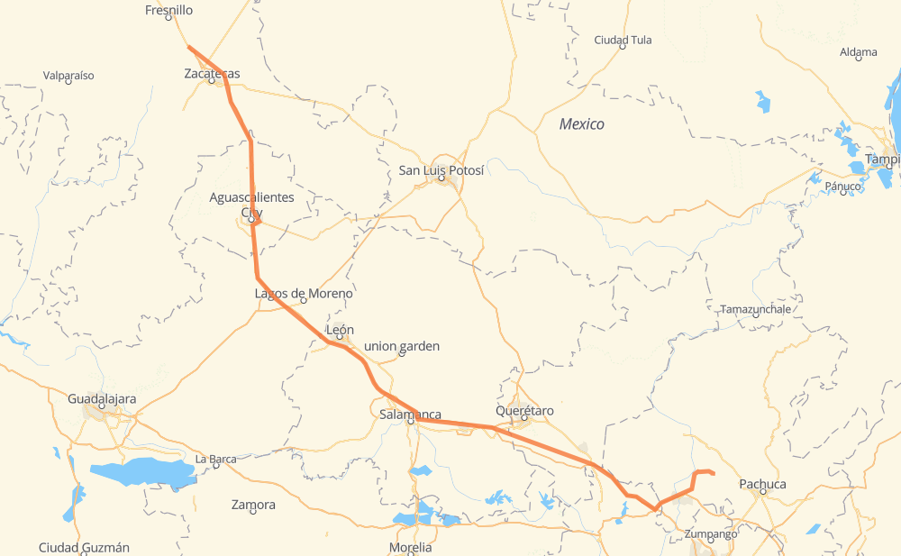
The distance from General Enrique Estrada to Los Filtros is 384 miles by road including 262 miles on motorways. Road takes approximately 6 hours and 18 minutes and goes through Aguascalientes, Salamanca, Celaya, Víctor Rosales, Hacienda Nueva, San Pedro Piedra Gorda and Pabellón de Arteaga.
| Shortest distance by air | 303 mi ✈️ |
| Car route length | 384 mi 🚗 |
| Driving time | 6 h 18 min |
| Fuel amount | 13.1 gal |
| Fuel cost | 51.3 USD |
| Toll roads cost | 557 + ? MXN |
| Point | Distance | Time | Fuel | |
| General Enrique Estrada | 0 mi | 00 min | 0.0 gal | |
|
MEX 45D 7 mi, 06 min
|
||||
| Víctor Rosales | 7 mi | 06 min | 0.1 gal | |
|
MEX 45D MEX 45 11 mi, 12 min
|
||||
| Hacienda Nueva | 18 mi | 18 min | 0.5 gal | |
|
MEX 45D 36 mi, 39 min
|
||||
| San Pedro Piedra Gorda | 54 mi | 58 min | 1.7 gal | |
|
MEX 45D MEX 45 22 mi, 23 min
|
||||
| Pabellón de Arteaga | 76 mi | 1 h 22 min | 2.5 gal | |
|
MEX 45 5 mi, 05 min
|
||||
| San Francisco de Los Romo | 81 mi | 1 h 28 min | 2.7 gal | |
|
MEX 45 16 mi, 17 min
|
||||
| Aguascalientes | 97 mi | 1 h 45 min | 3.2 gal | |
|
MEX 70 MEX 45D 127 mi, 1 h 58 min
|
||||
| Salamanca | 224 mi | 3 h 44 min | 7.6 gal | |
|
MEX 45D 19 mi, 18 min
|
||||
| Celaya | 244 mi | 4 h 02 min | 8.2 gal | |
|
MEX 45D MEX 47D 140 mi, 2 h 15 min
|
||||
| Los Filtros | 384 mi | 6 h 18 min | 13.0 gal | |
Frequently Asked Questions
How many toll booths are there from General Enrique Estrada to Los Filtros?
There are 12 toll booths between General Enrique Estrada and Los Filtros: Calera, Veta Grande, Zacatecas, Encarnacion De Diaz, León - Aguascalientes, Puerto Interior, Mendoza, Cerro Gordo, Tula 1, Queretaro, Palmillas and Palmilas - Apaseo.
How much does the toll booths cost from General Enrique Estrada to Los Filtros?
Toll roads cost: Calera (23 MXN) + Veta Grande (48 MXN) + Zacatecas (41 MXN) + Encarnacion De Diaz (150 MXN) + León - Aguascalientes (153 MXN) + Puerto Interior (?) + Mendoza (53 MXN) + Cerro Gordo (?) + Palmilas - Apaseo (?) + Palmillas (89 MXN) + Queretaro (?) + Tula 1 (?) = 557 + ? MXN
How much does it cost to drive from General Enrique Estrada to Los Filtros?
Fuel cost: 51.3 USD
This fuel cost is calculated as: (Route length 384 mi) / (Fuel consumption 29.4 mpg) * (Fuel price 3.93 USD / gal)
You can adjust fuel consumption and fuel price here.
Toll roads cost: 557 + ? MXN
How long is a car ride from General Enrique Estrada to Los Filtros?
Driving time: 6 h 18 min
This time is calculated for driving at the maximum permitted speed, taking into account traffic rules restrictions.
- 175 mi with a maximum speed 68 mph = 2 h 33 min
- 71 mi with a maximum speed 62 mph = 1 h 8 min
- 75 mi with a maximum speed 56 mph = 1 h 19 min
- 24 mi with a maximum speed 56 mph = 25 min
- 37 mi with a maximum speed 50 mph = 45 min
- 2 mi with a maximum speed 31 mph = 3 min
- 1 mi with a maximum speed 19 mph = 1 min
The calculated driving time does not take into account intermediate stops and traffic jams.
How far is General Enrique Estrada to Los Filtros by land?
The distance between General Enrique Estrada and Los Filtros is 384 mi by road including 261.6 mi on motorways.
Precise satellite coordinates of highways were used for this calculation. The start and finish points are the centers of General Enrique Estrada and Los Filtros respectively.
How far is General Enrique Estrada to Los Filtros by plane?
The shortest distance (air line, as the crow flies) between General Enrique Estrada and Los Filtros is 303.2 mi.
This distance is calculated using the Haversine formula as a great-circle distance between two points on the surface of a sphere. The start and finish points are the centers of General Enrique Estrada and Los Filtros respectively. Actual distance between airports may be different.
How many hours is General Enrique Estrada from Los Filtros by plane?
Boeing 737 airliner needs 36 min to cover the distance of 303 mi at a cruising speed of 497 mph.
Small plane "Cessna 172" needs 2 h 13 min to flight this distance at average speed of 136 mph.
This time is approximate and do not take into account takeoff and landing times, airport location and other real world factors.
How long is a helicopter ride from General Enrique Estrada to Los Filtros?
Fast helicopter "Eurocopter AS350" or "Hughes OH-6 Cayuse" need 2 h 2 min to cover the distance of 303 mi at a cruising speed of 149 mph.
Popular "Robinson R44" needs 2 h 19 min to flight this distance at average speed of 130 mph.
This time is approximate and do not take into account takeoff and landing times, aerodrome location and other real world factors.
What city is halfway between General Enrique Estrada and Los Filtros?
The halfway point between General Enrique Estrada and Los Filtros is La Aldea. It is located about 1 mi from the exact midpoint by road.
The distance from La Aldea to General Enrique Estrada is 191 mi and driving will take about 3 h 11 min. The road between La Aldea and Los Filtros has length 193 mi and will take approximately 3 h 6 min.
The other cities located close to halfway point:
Where is General Enrique Estrada in relation to Los Filtros?
General Enrique Estrada is located 303 mi north-west of Los Filtros.
General Enrique Estrada has geographic coordinates: latitude 22.99514, longitude -102.74018.
Los Filtros has geographic coordinates: latitude 20.21888, longitude -99.08861.
Which highway goes from General Enrique Estrada to Los Filtros?
The route from General Enrique Estrada to Los Filtros follows MEX 45D.
Other minor sections pass along the road:
- MEX 45: 53 mi
- MEX 47D: 52 mi
- MEX 43D: 48 mi
- MEX 57D: 35 mi
- MEX 70: 33 mi
- MEX M40D: 16 mi
- MEX 54: 1 mi