Distance between Goiânia and Bairro São José
The distance from Goiânia to Bairro São José is 1,317 miles by road. Road takes approximately 24 hours and 30 minutes and goes through Caxias, Negrão de Lima, Chácara Bom Retiro, Setor Galiléia, Santana, Serrano II and Estreito.
| Shortest distance by air | 1,046 mi ✈️ |
| Car route length | 1,317.3 mi 🚗 |
| Driving time | 24 h 30 min |
| Fuel amount | 44.8 gal |
| Fuel cost | 176.1 USD |
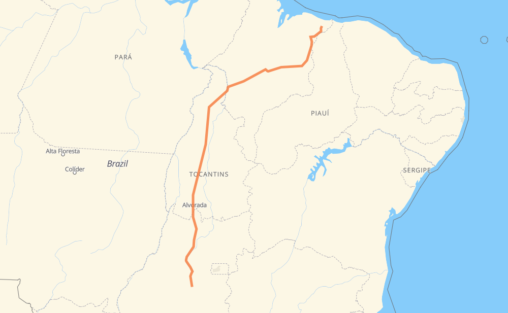
| Point | Distance | Time | Fuel | |
| Goiânia | 0 mi | 00 min | 0.0 gal | |
|
3 mi, 03 min
|
||||
| Negrão de Lima | 3 mi | 03 min | 0.1 gal | |
|
GO-080 11 mi, 12 min
|
||||
| Chácara Bom Retiro | 14 mi | 16 min | 0.2 gal | |
|
GO-080 104 mi, 1 h 53 min
|
||||
| Jardim Paulista | 117 mi | 2 h 09 min | 3.7 gal | |
|
BR-153 144 mi, 2 h 42 min
|
||||
| Setor Galiléia | 261 mi | 4 h 52 min | 8.6 gal | |
|
BR-153 216 mi, 3 h 55 min
|
||||
| Santana | 477 mi | 8 h 47 min | 16.0 gal | |
|
BR-153 11 mi, 12 min
|
||||
| Serrano II | 488 mi | 8 h 59 min | 16.5 gal | |
|
BR-153 298 mi, 5 h 24 min
|
||||
| Estreito | 786 mi | 14 h 24 min | 26.6 gal | |
|
BR-226 354 mi, 6 h 48 min
|
||||
| Caxias | 1,140 mi | 21 h 13 min | 38.5 gal | |
|
BR-316 MA-034 177 mi, 3 h 16 min
|
||||
| Bairro São José | 1,317 mi | 24 h 30 min | 44.7 gal | |
Frequently Asked Questions
How much does it cost to drive from Goiânia to Bairro São José?
Fuel cost: 176.1 USD
This fuel cost is calculated as: (Route length 1,317.3 mi) / (Fuel consumption 29.4 mpg) * (Fuel price 3.93 USD / gal)
You can adjust fuel consumption and fuel price here.
How long is a car ride from Goiânia to Bairro São José?
Driving time: 24 h 30 min
This time is calculated for driving at the maximum permitted speed, taking into account traffic rules restrictions.
- 886 mi with a maximum speed 56 mph = 15 h 49 min
- 430 mi with a maximum speed 50 mph = 8 h 38 min
- 1 mi with a maximum speed 37 mph = 1 min
The calculated driving time does not take into account intermediate stops and traffic jams.
How far is Goiânia to Bairro São José by land?
The distance between Goiânia and Bairro São José is 1,317.3 mi by road.
Precise satellite coordinates of highways were used for this calculation. The start and finish points are the centers of Goiânia and Bairro São José respectively.
How far is Goiânia to Bairro São José by plane?
The shortest distance (air line, as the crow flies) between Goiânia and Bairro São José is 1,046.4 mi.
This distance is calculated using the Haversine formula as a great-circle distance between two points on the surface of a sphere. The start and finish points are the centers of Goiânia and Bairro São José respectively. Actual distance between airports may be different.
How many hours is Goiânia from Bairro São José by plane?
Boeing 737 airliner needs 2 h 6 min to cover the distance of 1,046 mi at a cruising speed of 497 mph.
Small plane "Cessna 172" needs 7 h 39 min to flight this distance at average speed of 136 mph.
This time is approximate and do not take into account takeoff and landing times, airport location and other real world factors.
How long is a helicopter ride from Goiânia to Bairro São José?
Fast helicopter "Eurocopter AS350" or "Hughes OH-6 Cayuse" need 7 h 1 min to cover the distance of 1,046 mi at a cruising speed of 149 mph.
Popular "Robinson R44" needs 8 h 1 min to flight this distance at average speed of 130 mph.
This time is approximate and do not take into account takeoff and landing times, aerodrome location and other real world factors.
What city is halfway between Goiânia and Bairro São José?
The halfway point between Goiânia and Bairro São José is Ponta do Asfalto. It is located about 71 mi from the exact midpoint by road.
The distance from Ponta do Asfalto to Goiânia is 729 mi and driving will take about 13 h 20 min. The road between Ponta do Asfalto and Bairro São José has length 587 mi and will take approximately 11 h 9 min.
The other cities located close to halfway point:
Where is Goiânia in relation to Bairro São José?
Goiânia is located 1,046 mi south-west of Bairro São José.
Goiânia has geographic coordinates: latitude -16.68088, longitude -49.25327.
Bairro São José has geographic coordinates: latitude -3.11888, longitude -42.39377.
Which highway goes from Goiânia to Bairro São José?
The route from Goiânia to Bairro São José follows BR-153, BR-226, MA-034, GO-080.
Other minor sections pass along the road:
- BR-414: 22 mi
- BR-010: 17 mi
- BR-222: 14 mi
- BR-316: 13 mi
- MA-307: 10 mi
- MA-327: 7 mi
- BR-230: 1 mi
- BR-135: 1 mi