Distance between Golfo de Santa Clara and Rancho Gallardo
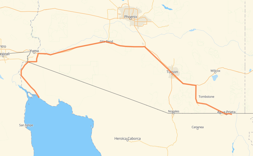
The distance from Golfo de Santa Clara to Rancho Gallardo is 465 miles by road including 273 miles on motorways. Road takes approximately 7 hours and 49 minutes and goes through San Luis Rio Colorado, Tucson, Agua Prieta, San Luis, Fortuna Foothills, Wellton and Gila Bend.
| Shortest distance by air | 302 mi ✈️ |
| Car route length | 464.8 mi 🚗 |
| Driving time | 7 h 49 min |
| Fuel amount | 15.8 gal |
| Fuel cost | 61.7 USD |
| Point | Distance | Time | Fuel | |
| Golfo de Santa Clara | 0 mi | 00 min | 0.0 gal | |
|
SON 003 Spur SON 003 73 mi, 1 h 23 min
|
||||
| San Luis Rio Colorado | 73 mi | 1 h 23 min | 2.5 gal | |
|
MEX 2 4 mi, 05 min
|
||||
| San Luis | 77 mi | 1 h 29 min | 2.5 gal | |
|
AZ 195 28 mi, 30 min
|
||||
| Fortuna Foothills | 105 mi | 1 h 59 min | 3.5 gal | |
|
I 8 14 mi, 13 min
|
||||
| Wellton | 119 mi | 2 h 12 min | 3.9 gal | |
|
I 8 87 mi, 1 h 16 min
|
||||
| Gila Bend | 207 mi | 3 h 29 min | 6.9 gal | |
|
I 8 62 mi, 54 min
|
||||
| Casa Grande | 268 mi | 4 h 24 min | 9.1 gal | |
|
I 8 I 10 67 mi, 1 h 02 min
|
||||
| Tucson | 336 mi | 5 h 26 min | 10.9 gal | |
|
I 10 AZ 90 119 mi, 2 h 08 min
|
||||
| Agua Prieta | 455 mi | 7 h 35 min | 15.4 gal | |
|
MEX 2 11 mi, 13 min
|
||||
| Rancho Gallardo | 466 mi | 7 h 49 min | 15.8 gal | |
Frequently Asked Questions
How much does it cost to drive from Golfo de Santa Clara to Rancho Gallardo?
Fuel cost: 61.7 USD
This fuel cost is calculated as: (Route length 464.8 mi) / (Fuel consumption 29.4 mpg) * (Fuel price 3.9 USD / gal)
You can adjust fuel consumption and fuel price here.
How long is a car ride from Golfo de Santa Clara to Rancho Gallardo?
Driving time: 7 h 49 min
This time is calculated for driving at the maximum permitted speed, taking into account traffic rules restrictions.
- 222 mi with a maximum speed 68 mph = 3 h 15 min
- 26 mi with a maximum speed 65 mph = 24 min
- 6 mi with a maximum speed 62 mph = 5 min
- 78 mi with a maximum speed 56 mph = 1 h 23 min
- 48 mi with a maximum speed 56 mph = 51 min
- 10 mi with a maximum speed 55 mph = 11 min
- 63 mi with a maximum speed 50 mph = 1 h 15 min
- 4 mi with a maximum speed 45 mph = 4 min
- 1 mi with a maximum speed 37 mph = 2 min
- 4 mi with a maximum speed 31 mph = 8 min
- 1 mi with a maximum speed 30 mph = 2 min
- 1 mi with a maximum speed 25 mph = 1 min
The calculated driving time does not take into account intermediate stops and traffic jams.
How far is Golfo de Santa Clara to Rancho Gallardo by land?
The distance between Golfo de Santa Clara and Rancho Gallardo is 464.8 mi by road including 273.4 mi on motorways.
Precise satellite coordinates of highways were used for this calculation. The start and finish points are the centers of Golfo de Santa Clara and Rancho Gallardo respectively.
How far is Golfo de Santa Clara to Rancho Gallardo by plane?
The shortest distance (air line, as the crow flies) between Golfo de Santa Clara and Rancho Gallardo is 302 mi.
This distance is calculated using the Haversine formula as a great-circle distance between two points on the surface of a sphere. The start and finish points are the centers of Golfo de Santa Clara and Rancho Gallardo respectively. Actual distance between airports may be different.
How many hours is Golfo de Santa Clara from Rancho Gallardo by plane?
Boeing 737 airliner needs 36 min to cover the distance of 302 mi at a cruising speed of 497 mph.
Small plane "Cessna 172" needs 2 h 12 min to flight this distance at average speed of 136 mph.
This time is approximate and do not take into account takeoff and landing times, airport location and other real world factors.
How long is a helicopter ride from Golfo de Santa Clara to Rancho Gallardo?
Fast helicopter "Eurocopter AS350" or "Hughes OH-6 Cayuse" need 2 h 1 min to cover the distance of 302 mi at a cruising speed of 149 mph.
Popular "Robinson R44" needs 2 h 18 min to flight this distance at average speed of 130 mph.
This time is approximate and do not take into account takeoff and landing times, aerodrome location and other real world factors.
What city is halfway between Golfo de Santa Clara and Rancho Gallardo?
The halfway point between Golfo de Santa Clara and Rancho Gallardo is Freeman. It is located about 2 mi from the exact midpoint by road.
The distance from Freeman to Golfo de Santa Clara is 234 mi and driving will take about 3 h 53 min. The road between Freeman and Rancho Gallardo has length 231 mi and will take approximately 3 h 55 min.
The other cities located close to halfway point:
Where is Golfo de Santa Clara in relation to Rancho Gallardo?
Golfo de Santa Clara is located 302 mi west of Rancho Gallardo.
Golfo de Santa Clara has geographic coordinates: latitude 31.68774, longitude -114.49423.
Rancho Gallardo has geographic coordinates: latitude 31.30583, longitude -109.39033.
Which highway goes from Golfo de Santa Clara to Rancho Gallardo?
The route from Golfo de Santa Clara to Rancho Gallardo follows I 8, I 10, SON 003.
Other minor sections pass along the road:
- AZ 90: 47 mi
- AZ 80: 32 mi
- AZ 195: 21 mi
- MEX 2: 10 mi
- SON 003 Spur: 2 mi
- SR 80: 1 mi
- US 191 Bus: 1 mi