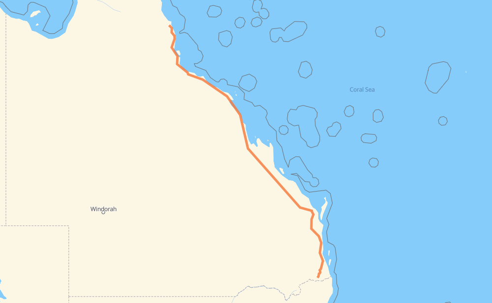
Distance between Gordonvale and Rathdowney

The distance from Gordonvale to Rathdowney is 1,106 miles by road including 134 miles on motorways. Road takes approximately 20 hours and 23 minutes and goes through Rockhampton, Maryborough, Gympie, El Arish, Tully, Cardwell and Ingham.

There are tolls on the route.
Shortest distance by air 890 mi ✈️
Car route length 1,106 mi 🚗
Driving time 20 h 23 min
Fuel amount 37.6 gal
Fuel cost 147.8 USD
Click here to load the interactive map
Compare this route in other services:
City
Town
Village
Hamlet
Motorway
Primary
Secondary
Unclassified
Point Distance Time Fuel
Gordonvale 0 mi 0:00 00 min 0.0 gal
A1 63 mi, 1 h 11 min
El Arish 63 mi 1:11 1 h 11 min 2.0 gal
A1 9 mi, 10 min
Tully 72 mi 1:21 1 h 21 min 2.3 gal
A1 28 mi, 31 min
Cardwell 100 mi 1:52 1 h 52 min 3.3 gal
A1 31 mi, 34 min
Ingham 131 mi 2:26 2 h 26 min 4.3 gal
A1 62 mi, 1 h 07 min
Shaw 193 mi 3:34 3 h 34 min 6.5 gal
A1 456 mi, 8 h 32 min
Rockhampton 650 mi 12:06 12 h 06 min 22.0 gal
A1 237 mi, 4 h 27 min
Maryborough 887 mi 16:34 16 h 34 min 30.1 gal
A1 50 mi, 58 min
Gympie 937 mi 17:33 17 h 33 min 31.7 gal
A1 M1 169 mi, 2 h 49 min
Rathdowney 1,106 mi 20:23 20 h 23 min 37.5 gal
City
Town
Village
Hamlet
Motorway
Primary
Secondary
Unclassified
Point Distance Time Fuel
Gordonvale 0 mi 0:00 00 min 0.0 gal
A1 10 mi, 11 min
Fishery Falls 10 mi 0:11 11 min 0.3 gal
A1 4 mi, 04 min
Deeral 14 mi 0:15 15 min 0.4 gal
A1 9 mi, 09 min
Babinda 22 mi 0:25 25 min 0.7 gal
A1 2 mi, 03 min
Mirriwinni 25 mi 0:28 28 min 0.8 gal
A1 20 mi, 23 min
Mourilyan 45 mi 0:51 51 min 1.5 gal
A1 12 mi, 13 min
Silkwood 58 mi 1:05 1 h 05 min 1.9 gal
A1 5 mi, 05 min
El Arish 63 mi 1:11 1 h 11 min 2.0 gal
A1 9 mi, 10 min
Tully 72 mi 1:21 1 h 21 min 2.3 gal
A1 28 mi, 31 min
Cardwell 100 mi 1:52 1 h 52 min 3.3 gal
A1 31 mi, 34 min
Ingham 131 mi 2:26 2 h 26 min 4.3 gal
A1 6 mi, 06 min
Toobanna 137 mi 2:33 2 h 33 min 4.6 gal
A1 14 mi, 15 min
Bambaroo 150 mi 2:48 2 h 48 min 5.0 gal
A1 7 mi, 08 min
Mutarnee 158 mi 2:56 2 h 56 min 5.3 gal
A1 9 mi, 10 min
Rollingstone 168 mi 3:06 3 h 06 min 5.7 gal
A1 25 mi, 27 min
Shaw 193 mi 3:33 3 h 33 min 6.5 gal
A1 7 mi, 06 min
Douglas 200 mi 3:40 3 h 40 min 6.8 gal
A1 8 mi, 09 min
Stuart 209 mi 3:50 3 h 50 min 7.0 gal
A1 43 mi, 46 min
Brandon 252 mi 4:36 4 h 36 min 8.5 gal
A1 3 mi, 04 min
Ayr 255 mi 4:40 4 h 40 min 8.6 gal
A1 9 mi, 09 min
Home Hill 263 mi 4:50 4 h 50 min 8.9 gal
A1 24 mi, 26 min
Gumlu 287 mi 5:16 5 h 16 min 9.6 gal
A1 10 mi, 11 min
Guthalungra 297 mi 5:28 5 h 28 min 10.0 gal
A1 24 mi, 26 min
Merinda 321 mi 5:55 5 h 55 min 10.9 gal
A1 14 mi, 15 min
Intaburra 335 mi 6:10 6 h 10 min 11.3 gal
A1 11 mi, 12 min
Debella 347 mi 6:23 6 h 23 min 11.7 gal
A1 12 mi, 13 min
Mrytlevale 359 mi 6:36 6 h 36 min 12.0 gal
A1 13 mi, 14 min
Goorganga Plains 372 mi 6:51 6 h 51 min 12.5 gal
A1 5 mi, 05 min
Lethebrook 377 mi 6:56 6 h 56 min 12.7 gal
A1 21 mi, 22 min
Pindi Pindi 397 mi 7:18 7 h 18 min 13.2 gal
A1 12 mi, 13 min
Kolijo 409 mi 7:31 7 h 31 min 13.9 gal
A1 7 mi, 07 min
Buthurra 417 mi 7:39 7 h 39 min 14.1 gal
A1 7 mi, 07 min
Hampden 424 mi 7:47 7 h 47 min 14.3 gal
A1 6 mi, 06 min
The Leap 430 mi 7:53 7 h 53 min 14.6 gal
A1 6 mi, 06 min
Farleigh 436 mi 8:00 8 h 00 min 14.8 gal
A1 9 mi, 09 min
Paget 444 mi 8:10 8 h 10 min 15.1 gal
A1 6 mi, 07 min
Sandy Creek 451 mi 8:18 8 h 18 min 15.2 gal
A1 14 mi, 15 min
Jilalan 465 mi 8:33 8 h 33 min 15.8 gal
A1 6 mi, 06 min
Yukan 470 mi 8:40 8 h 40 min 15.8 gal
A1 7 mi, 07 min
Koumala 477 mi 8:48 8 h 48 min 16.2 gal
A1 5 mi, 06 min
Mount Christian 482 mi 8:54 8 h 54 min 16.3 gal
A1 7 mi, 07 min
Ilbilbie 488 mi 9:02 9 h 02 min 16.5 gal
A1 6 mi, 06 min
West Hill 494 mi 9:08 9 h 08 min 16.7 gal
A1 10 mi, 11 min
Carmila 504 mi 9:20 9 h 20 min 17.0 gal
A1 5 mi, 06 min
Flaggy Rock 510 mi 9:26 9 h 26 min 17.3 gal
A1 5 mi, 05 min
Joyview 514 mi 9:32 9 h 32 min 17.5 gal
A1 7 mi, 08 min
Clairview 521 mi 9:40 9 h 40 min 17.6 gal
A1 26 mi, 29 min
Prospect Hill 547 mi 10:09 10 h 09 min 18.5 gal
A1 40 mi, 44 min
Marlborough 588 mi 10:53 10 h 53 min 19.8 gal
A1 35 mi, 39 min
Yaamba 623 mi 11:33 11 h 33 min 21.0 gal
A1 11 mi, 12 min
The Caves 634 mi 11:45 11 h 45 min 21.4 gal
A1 9 mi, 10 min
Parkhurst 642 mi 11:56 11 h 56 min 21.8 gal
A1 3 mi, 04 min
Kawana 646 mi 12:00 12 h 00 min 21.9 gal
A1 4 mi, 05 min
Rockhampton 650 mi 12:05 12 h 05 min 22.0 gal
A1 21 mi, 23 min
Bajool 671 mi 12:29 12 h 29 min 22.7 gal
A1 22 mi, 23 min
Ambrose 692 mi 12:52 12 h 52 min 23.5 gal
A1 5 mi, 05 min
Mount Larcom 697 mi 12:58 12 h 58 min 23.6 gal
A1 11 mi, 12 min
West Stowe 708 mi 13:11 13 h 11 min 24.0 gal
A1 4 mi, 04 min
River Ranch 713 mi 13:15 13 h 15 min 24.2 gal
A1 6 mi, 06 min
Calliope 718 mi 13:22 13 h 22 min 24.4 gal
A1 6 mi, 07 min
Benaraby 724 mi 13:29 13 h 29 min 24.5 gal
A1 9 mi, 10 min
Iveragh 733 mi 13:39 13 h 39 min 24.8 gal
A1 9 mi, 10 min
Bororen 743 mi 13:50 13 h 50 min 25.1 gal
A1 73 mi, 1 h 20 min
Gin Gin 816 mi 15:10 15 h 10 min 27.5 gal
A1 20 mi, 22 min
Booyal 836 mi 15:33 15 h 33 min 28.1 gal
A1 11 mi, 11 min
Apple Tree Creek 847 mi 15:45 15 h 45 min 28.8 gal
A1 2 mi, 02 min
Childers 849 mi 15:48 15 h 48 min 28.8 gal
A1 5 mi, 06 min
Doolbi 854 mi 15:54 15 h 54 min 29.0 gal
A1 19 mi, 21 min
Howard 873 mi 16:16 16 h 16 min 29.4 gal
A1 11 mi, 12 min
Aldershot 884 mi 16:28 16 h 28 min 30.0 gal
A1 4 mi, 04 min
Maryborough 887 mi 16:33 16 h 33 min 30.1 gal
A1 21 mi, 24 min
Tiaro 908 mi 16:57 16 h 57 min 30.5 gal
A1 14 mi, 17 min
Gunalda 921 mi 17:14 17 h 14 min 31.3 gal
A1 16 mi, 17 min
Gympie 937 mi 17:32 17 h 32 min 31.7 gal
A1 M1 23 mi, 22 min
Pomona 960 mi 17:54 17 h 54 min 32.6 gal
M1 9 mi, 08 min
Cooroy 969 mi 18:03 18 h 03 min 32.7 gal
M1 37 mi, 32 min
Beerburrum 1,005 mi 18:36 18 h 36 min 34.1 gal
M1 13 mi, 12 min
Burpengary East 1,018 mi 18:48 18 h 48 min 34.6 gal
M1 6 mi, 05 min
Dakabin 1,023 mi 18:53 18 h 53 min 34.8 gal
M1 3 mi, 03 min
Griffin 1,027 mi 18:56 18 h 56 min 34.9 gal
M1 8 mi, 07 min
Boondall 1,035 mi 19:03 19 h 03 min 35.1 gal
M1 16 mi, 15 min
Mackenzie 1,050 mi 19:19 19 h 19 min 35.7 gal
M1 M2 5 mi, 04 min
Kuraby 1,055 mi 19:23 19 h 23 min 35.9 gal
M2 7 mi, 07 min
Hillcrest 1,062 mi 19:31 19 h 31 min 36.1 gal
13 6 mi, 06 min
Munruben 1,068 mi 19:37 19 h 37 min 36.3 gal
13 3 mi, 03 min
South Maclean 1,070 mi 19:40 19 h 40 min 36.4 gal
13 3 mi, 03 min
Jimboomba 1,073 mi 19:44 19 h 44 min 36.4 gal
13 13 mi, 15 min
Beaudesert 1,087 mi 19:59 19 h 59 min 36.9 gal
13 19 mi, 21 min
Rathdowney 1,106 mi 20:21 20 h 21 min 37.5 gal

Frequently Asked Questions

How much does it cost to drive from Gordonvale to Rathdowney?

Fuel cost: 147.8 USD

This fuel cost is calculated as: (Route length 1,106 mi) / (Fuel consumption 29.4 mpg) * (Fuel price 3.93 USD / gal)

You can adjust fuel consumption and fuel price here.

How long is a car ride from Gordonvale to Rathdowney?

Driving time: 20 h 23 min

This time is calculated for driving at the maximum permitted speed, taking into account traffic rules restrictions.

  • 60 mi with a maximum speed 68 mph = 52 min
  • 62 mi with a maximum speed 62 mph = 59 min
  • 646 mi with a maximum speed 56 mph = 11 h 32 min
  • 6 mi with a maximum speed 56 mph = 6 min
  • 299 mi with a maximum speed 50 mph = 6 h 1 min
  • 13 mi with a maximum speed 43 mph = 18 min
  • 17 mi with a maximum speed 37 mph = 26 min
  • 3 mi with a maximum speed 31 mph = 5 min

The calculated driving time does not take into account intermediate stops and traffic jams.

How far is Gordonvale to Rathdowney by land?

The distance between Gordonvale and Rathdowney is 1,106 mi by road including 133.6 mi on motorways.

Precise satellite coordinates of highways were used for this calculation. The start and finish points are the centers of Gordonvale and Rathdowney respectively.

How far is Gordonvale to Rathdowney by plane?

The shortest distance (air line, as the crow flies) between Gordonvale and Rathdowney is 890.4 mi.

This distance is calculated using the Haversine formula as a great-circle distance between two points on the surface of a sphere. The start and finish points are the centers of Gordonvale and Rathdowney respectively. Actual distance between airports may be different.

How many hours is Gordonvale from Rathdowney by plane?

Boeing 737 airliner needs 1 h 47 min to cover the distance of 890 mi at a cruising speed of 497 mph.

Small plane "Cessna 172" needs 6 h 30 min to flight this distance at average speed of 136 mph.

This time is approximate and do not take into account takeoff and landing times, airport location and other real world factors.

How long is a helicopter ride from Gordonvale to Rathdowney?

Fast helicopter "Eurocopter AS350" or "Hughes OH-6 Cayuse" need 5 h 58 min to cover the distance of 890 mi at a cruising speed of 149 mph.

Popular "Robinson R44" needs 6 h 49 min to flight this distance at average speed of 130 mph.

This time is approximate and do not take into account takeoff and landing times, aerodrome location and other real world factors.

What city is halfway between Gordonvale and Rathdowney?

The halfway point between Gordonvale and Rathdowney is Prospect Hill. It is located about 6 mi from the exact midpoint by road.

The distance from Prospect Hill to Gordonvale is 547 mi and driving will take about 10 h 9 min. The road between Prospect Hill and Rathdowney has length 559 mi and will take approximately 10 h 13 min.

The other cities located close to halfway point:

  • Clairview is in 521 mi from Gordonvale and 585 mi from Rathdowney
  • Marlborough is in 588 mi from Gordonvale and 518 mi from Rathdowney
  • Joyview is in 514 mi from Gordonvale and 592 mi from Rathdowney

Where is Gordonvale in relation to Rathdowney?

Gordonvale is located 890 mi north-west of Rathdowney.

Gordonvale has geographic coordinates: latitude -17.09359, longitude 145.78418.

Rathdowney has geographic coordinates: latitude -28.21006, longitude 152.86524.

Which highway goes from Gordonvale to Rathdowney?

The route from Gordonvale to Rathdowney follows A1, M1.

Other minor sections pass along the road:

  • 13: 43 mi
  • 16: 19 mi
  • M2: 6 mi
The distance between Gordonvale and Rathdowney is ranked 26,030th in the ranking popularity.
Have any questions? Contact us!