Distance between Grézolles and Carros

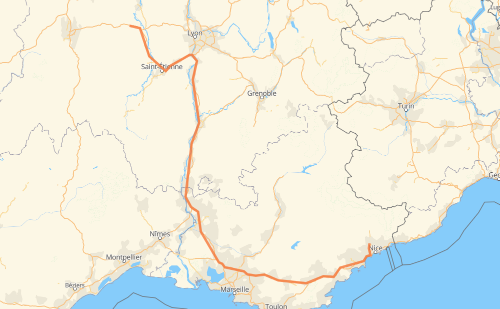
The distance from Grézolles to Carros is 352 miles by road including 334 miles on motorways. Road takes approximately 5 hours and 25 minutes and goes through Saint-Étienne, Aviñón, Aix-en-Provence and Niza.

There are tolls on the route.
Click here to load the interactive map
Compare this route in other services:
City
Town
Village
Hamlet
Motorway
Primary
Secondary
Unclassified
Point Distance Time Fuel
Grézolles 0 mi 0:00 00 min 0.0 gal
D 1 A 72 45 mi, 43 min
Saint-Jean-Bonnefonds 45 mi 0:43 43 min 1.4 gal
A 72 6 mi, 06 min
Saint-Chamond 50 mi 0:49 49 min 1.6 gal
A 47 8 mi, 08 min
Rive-de-Gier 58 mi 0:57 57 min 1.9 gal
A 47 7 mi, 07 min
Givors 66 mi 1:05 1 h 05 min 2.2 gal
A 47 A 7 6 mi, 06 min
Vienne 72 mi 1:12 1 h 12 min 2.4 gal
A 7 124 mi, 1 h 50 min
Aviñón 196 mi 3:02 3 h 02 min 6.6 gal
A 7 41 mi, 36 min
Aix-en-Provence 237 mi 3:39 3 h 39 min 7.9 gal
A 8 109 mi, 1 h 38 min
Niza 346 mi 5:18 5 h 18 min 11.6 gal
A 8 M 6210 8 mi, 10 min
Carros 354 mi 5:28 5 h 28 min 12.0 gal
City
Town
Village
Hamlet
Motorway
Primary
Secondary
Unclassified
Point Distance Time Fuel
Grézolles 0 mi 0:00 00 min 0.0 gal
D 1 A 89 18 mi, 18 min
Chambéon 18 mi 0:18 18 min 0.4 gal
A 72 7 mi, 05 min
Chalain-le-Comtal 25 mi 0:24 24 min 0.8 gal
A 72 2 mi, 02 min
Boisset-lès-Montrond 27 mi 0:26 26 min 0.9 gal
A 72 10 mi, 08 min
Les Perrotins 37 mi 0:35 35 min 1.2 gal
A 72 2 mi, 01 min
La Fouillouse 39 mi 0:36 36 min 1.3 gal
A 72 2 mi, 02 min
Villars 41 mi 0:38 38 min 1.4 gal
A 72 4 mi, 04 min
Saint-Jean-Bonnefonds 45 mi 0:43 43 min 1.4 gal
A 72 6 mi, 06 min
Saint-Chamond 50 mi 0:49 49 min 1.6 gal
A 47 4 mi, 03 min
L'Horme 54 mi 0:52 52 min 1.8 gal
A 47 4 mi, 04 min
Rive-de-Gier 58 mi 0:57 57 min 1.9 gal
A 47 2 mi, 02 min
Châteauneuf 60 mi 0:59 59 min 2.0 gal
A 47 2 mi, 01 min
Le-Moulin-Glattard 62 mi 1:01 1 h 01 min 2.1 gal
A 47 1 mi, 00 min
La-Fléchette 62 mi 1:01 1 h 01 min 2.1 gal
A 47 1 mi, 00 min
Saint-Romain-en-Gier 63 mi 1:02 1 h 02 min 2.1 gal
A 47 2 mi, 02 min
Givors 66 mi 1:05 1 h 05 min 2.2 gal
A 47 A 7 6 mi, 06 min
Vienne 72 mi 1:12 1 h 12 min 2.4 gal
A 7 2 mi, 02 min
Saint-Romain-en-Gal 75 mi 1:14 1 h 14 min 2.5 gal
A 7 6 mi, 04 min
Reventin-Vaugris 80 mi 1:18 1 h 18 min 2.7 gal
A 7 2 mi, 02 min
Auberives-sur-Varèze 82 mi 1:21 1 h 21 min 2.8 gal
A 7 3 mi, 02 min
L'Enclos 85 mi 1:23 1 h 23 min 2.9 gal
A 7 2 mi, 01 min
Salaise-sur-Sanne 88 mi 1:25 1 h 25 min 3.0 gal
A 7 2 mi, 01 min
Chanas 89 mi 1:27 1 h 27 min 3.0 gal
A 7 12 mi, 10 min
Villeneuve de Vals 101 mi 1:37 1 h 37 min 3.4 gal
A 7 5 mi, 04 min
La Burge 106 mi 1:41 1 h 41 min 3.5 gal
A 7 3 mi, 02 min
Les Malfondières 109 mi 1:44 1 h 44 min 3.7 gal
A 7 2 mi, 01 min
Les Chassis-Sud 111 mi 1:45 1 h 45 min 3.7 gal
A 7 3 mi, 02 min
Pont-de-l'Isère 113 mi 1:48 1 h 48 min 3.8 gal
A 7 2 mi, 02 min
Bourg-lès-Valence 116 mi 1:50 1 h 50 min 3.9 gal
A 7 4 mi, 03 min
Valence 119 mi 1:54 1 h 54 min 4.0 gal
A 7 3 mi, 02 min
Portes-lès-Valence 122 mi 1:57 1 h 57 min 4.2 gal
A 7 4 mi, 03 min
La Paillasse 126 mi 2:00 2 h 00 min 4.2 gal
A 7 9 mi, 07 min
Saulce-sur-Rhône 135 mi 2:08 2 h 08 min 4.6 gal
A 7 4 mi, 03 min
Les Tourrettes 139 mi 2:11 2 h 11 min 4.7 gal
A 7 7 mi, 06 min
Montboucher-sur-Jabron 146 mi 2:17 2 h 17 min 4.9 gal
A 7 19 mi, 16 min
Bollène 165 mi 2:34 2 h 34 min 5.5 gal
A 7 7 mi, 05 min
Mornas 171 mi 2:40 2 h 40 min 5.8 gal
A 7 3 mi, 02 min
Piolenc 175 mi 2:42 2 h 42 min 5.9 gal
A 7 9 mi, 08 min
Courthézon 184 mi 2:51 2 h 51 min 6.2 gal
A 7 6 mi, 04 min
Sorgues 190 mi 2:55 2 h 55 min 6.4 gal
A 7 3 mi, 02 min
Vedène 193 mi 2:58 2 h 58 min 6.5 gal
A 7 4 mi, 03 min
Aviñón 196 mi 3:01 3 h 01 min 6.6 gal
A 7 4 mi, 03 min
Cabannes 201 mi 3:05 3 h 05 min 6.8 gal
A 7 6 mi, 05 min
Orgon 207 mi 3:11 3 h 11 min 7.0 gal
A 7 4 mi, 03 min
Sénas 211 mi 3:14 3 h 14 min 7.1 gal
A 7 4 mi, 03 min
Lamanon 214 mi 3:18 3 h 18 min 7.3 gal
A 7 3 mi, 02 min
Salon de Provence 217 mi 3:20 3 h 20 min 7.3 gal
A 7 12 mi, 10 min
Coudoux 229 mi 3:31 3 h 31 min 7.8 gal
A 8 8 mi, 07 min
Aix-en-Provence 237 mi 3:38 3 h 38 min 7.9 gal
A 8 4 mi, 04 min
Palette 242 mi 3:43 3 h 43 min 8.2 gal
A 8 2 mi, 01 min
Pont de Bayeux 243 mi 3:44 3 h 44 min 8.3 gal
A 8 1 mi, 00 min
Le Canet 244 mi 3:45 3 h 45 min 8.3 gal
A 8 4 mi, 03 min
Châteauneuf-le-Rouge 248 mi 3:49 3 h 49 min 8.4 gal
A 8 4 mi, 04 min
Trets 253 mi 3:53 3 h 53 min 8.5 gal
A 8 4 mi, 03 min
Pourcieux 257 mi 3:57 3 h 57 min 8.7 gal
A 8 7 mi, 06 min
Saint-Maximin-la-Sainte-Baume 264 mi 4:03 4 h 03 min 8.8 gal
A 8 12 mi, 10 min
Brignoles 275 mi 4:13 4 h 13 min 9.1 gal
A 8 10 mi, 09 min
Le Luc 286 mi 4:22 4 h 22 min 9.7 gal
A 8 2 mi, 01 min
Le Théron 288 mi 4:23 4 h 23 min 9.7 gal
A 8 2 mi, 02 min
Les Termes 290 mi 4:25 4 h 25 min 9.8 gal
A 8 11 mi, 09 min
Le Muy 301 mi 4:35 4 h 35 min 10.2 gal
A 8 4 mi, 03 min
Roquebrune-sur-Argens 304 mi 4:38 4 h 38 min 10.2 gal
A 8 4 mi, 03 min
Puget-sur-Argens 308 mi 4:41 4 h 41 min 10.4 gal
A 8 4 mi, 03 min
Fréjus 311 mi 4:45 4 h 45 min 10.5 gal
A 8 12 mi, 10 min
Mandelieu-la-Napoule 324 mi 4:55 4 h 55 min 10.9 gal
A 8 3 mi, 02 min
Le Cannet 327 mi 4:58 4 h 58 min 11.1 gal
A 8 3 mi, 02 min
Mougins 330 mi 5:01 5 h 01 min 11.1 gal
A 8 3 mi, 02 min
Vallauris 333 mi 5:04 5 h 04 min 11.3 gal
A 8 2 mi, 02 min
Antibes 336 mi 5:06 5 h 06 min 11.3 gal
A 8 2 mi, 02 min
Villeneuve-Loubet 339 mi 5:08 5 h 08 min 11.5 gal
A 8 1 mi, 01 min
Cagnes-sur-Mer 340 mi 5:10 5 h 10 min 11.5 gal
A 8 6 mi, 06 min
Niza 346 mi 5:16 5 h 16 min 11.6 gal
A 8 M 6210 8 mi, 10 min
Carros 354 mi 5:27 5 h 27 min 12.0 gal

Frequently Asked Questions

How much does it cost to drive from Grézolles to Carros?

Fuel cost: 47 USD

This fuel cost is calculated as: (Route length 351.7 mi) / (Fuel consumption 29.4 mpg) * (Fuel price 3.93 USD / gal)

You can adjust fuel consumption and fuel price here.

How long is a car ride from Grézolles to Carros?

Driving time: 5 h 25 min

This time is calculated for driving at the maximum permitted speed, taking into account traffic rules restrictions.

  • 295 mi with a maximum speed 68 mph = 4 h 20 min
  • 6 mi with a maximum speed 56 mph = 6 min
  • 34 mi with a maximum speed 56 mph = 36 min
  • 7 mi with a maximum speed 50 mph = 9 min
  • 6 mi with a maximum speed 43 mph = 8 min
  • 1 mi with a maximum speed 31 mph = 2 min

The calculated driving time does not take into account intermediate stops and traffic jams.

How far is Grézolles to Carros by land?

The distance between Grézolles and Carros is 351.7 mi by road including 333.7 mi on motorways.

Precise satellite coordinates of highways were used for this calculation. The start and finish points are the centers of Grézolles and Carros respectively.

How far is Grézolles to Carros by plane?

The shortest distance (air line, as the crow flies) between Grézolles and Carros is 213.8 mi.

This distance is calculated using the Haversine formula as a great-circle distance between two points on the surface of a sphere. The start and finish points are the centers of Grézolles and Carros respectively. Actual distance between airports may be different.

How many hours is Grézolles from Carros by plane?

Boeing 737 airliner needs 25 min to cover the distance of 214 mi at a cruising speed of 497 mph.

Small plane "Cessna 172" needs 1 h 33 min to flight this distance at average speed of 136 mph.

This time is approximate and do not take into account takeoff and landing times, airport location and other real world factors.

How long is a helicopter ride from Grézolles to Carros?

Fast helicopter "Eurocopter AS350" or "Hughes OH-6 Cayuse" need 1 h 26 min to cover the distance of 214 mi at a cruising speed of 149 mph.

Popular "Robinson R44" needs 1 h 38 min to flight this distance at average speed of 130 mph.

This time is approximate and do not take into account takeoff and landing times, aerodrome location and other real world factors.

What city is halfway between Grézolles and Carros?

The halfway point between Grézolles and Carros is Piolenc. It is located about 1 mi from the exact midpoint by road.

The distance from Piolenc to Grézolles is 175 mi and driving will take about 2 h 42 min. The road between Piolenc and Carros has length 177 mi and will take approximately 2 h 42 min.

The other cities located close to halfway point:

  • Mornas is in 171 mi from Grézolles and 180 mi from Carros
  • Courthézon is in 184 mi from Grézolles and 168 mi from Carros
  • Bollène is in 165 mi from Grézolles and 187 mi from Carros

Where is Grézolles in relation to Carros?

Grézolles is located 214 mi north-west of Carros.

Grézolles has geographic coordinates: latitude 45.8628, longitude 3.95172.

Carros has geographic coordinates: latitude 43.7846, longitude 7.18785.

Which highway goes from Grézolles to Carros?

The route from Grézolles to Carros follows A 7, A 8.

Other minor sections pass along the road:

  • A 72: 34 mi
  • A 47: 19 mi
  • M 6202 bis: 5 mi
  • A 89: 4 mi
  • D 1: 4 mi
  • N 88: 3 mi
  • D 8: 2 mi
  • M 1: 1 mi
  • M 6210: 1 mi
Have any questions? Contact us!