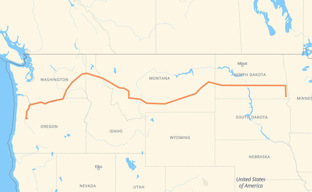
The distance from Hankinson to Lebanon is 1,630 miles by road including 1,506 miles on motorways. Road takes approximately 25 hours and 15 minutes and goes through Fargo, West Fargo, Bismarck, Mandan, Dickinson, Billings and Butte.
You can adjust fuel consumption and fuel price here.
How long is a car ride from Hankinson to Lebanon?
Driving time:
25 h 15 min
This time is calculated for driving at the maximum permitted speed, taking into account traffic rules restrictions.
1,005 mi with a maximum speed 68 mph = 14 h 46 min
185 mi with a maximum speed 65 mph = 2 h 50 min
190 mi with a maximum speed 62 mph = 3 h 3 min
50 mi with a maximum speed 60 mph = 49 min
111 mi with a maximum speed 56 mph = 1 h 59 min
27 mi with a maximum speed 55 mph = 29 min
4 mi with a maximum speed 50 mph = 5 min
55 mi with a maximum speed 50 mph = 1 h 5 min
1 mi with a maximum speed 45 mph = 1 min
1 mi with a maximum speed 35 mph = 1 min
The calculated driving time does not take into account intermediate stops and traffic jams.
How far is Hankinson to Lebanon by land?
The distance between Hankinson and Lebanon is 1,629.9 mi by road including 1,506.2 mi on motorways.
Precise satellite coordinates of highways were used for this calculation. The start and finish points are the centers of Hankinson and Lebanon respectively.
How far is Hankinson to Lebanon by plane?
The shortest distance (air line, as the crow flies) between Hankinson and Lebanon is 1,262.6 mi.
This distance is calculated using the Haversine formula as a great-circle distance between two points on the surface of a sphere. The start and finish points are the centers of Hankinson and Lebanon respectively. Actual distance between airports may be different.
How many hours is Hankinson from Lebanon by plane?
Boeing 737 airliner needs 2 h 32 min to cover the distance of 1,263 mi at a cruising speed of 497 mph.
Small plane "Cessna 172" needs 9 h 14 min to flight this distance at average speed of 136 mph.
This time is approximate and do not take into account takeoff and landing times, airport location and other real world factors.
How long is a helicopter ride from Hankinson to Lebanon?
Fast helicopter "Eurocopter AS350" or "Hughes OH-6 Cayuse" need 8 h 28 min to cover the distance of 1,263 mi at a cruising speed of 149 mph.
Popular "Robinson R44" needs 9 h 40 min to flight this distance at average speed of 130 mph.
This time is approximate and do not take into account takeoff and landing times, aerodrome location and other real world factors.
What city is halfway between Hankinson and Lebanon?
The halfway point between Hankinson and Lebanon is Belgrade. It is located about 1 mi from the exact midpoint by road.
The distance from Belgrade to Hankinson is 816 mi and driving will take about 12 h 30 min. The road between Belgrade and Lebanon has length 814 mi and will take approximately 12 h 45 min.
The other cities located close to halfway point:
Story is in 807 mi from Hankinson and 823 mi from Lebanon
Rocky Creek Trailer Court is in 804 mi from Hankinson and 826 mi from Lebanon
Canyon View Trailer Court is in 800 mi from Hankinson and 830 mi from Lebanon
Where is Hankinson in relation to Lebanon?
Hankinson is located 1,263 mi east of Lebanon.
Hankinson has geographic coordinates: latitude 46.06968, longitude -96.90175.
Lebanon has geographic coordinates: latitude 44.53651, longitude -122.90703.
Which highway goes from Hankinson to Lebanon?
The route from Hankinson to Lebanon follows I 90, I 94, US 395, US 12, I 84, US 52, US 30, WA 14, I 5.