Distance between Heino and Kade
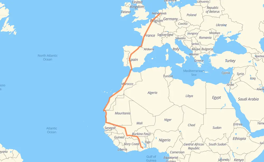
The distance from Heino to Kade is 5,032 miles by road including 1,982 miles on motorways. Road takes approximately 90 hours and 15 minutes and goes through Zwolle, Amersfoort, Utrecht, Antwerp, Ghent, Lille and Montreuil.
| Shortest distance by air | 3,227 mi ✈️ |
| Car route length | 5,031.9 mi 🚗 |
| Driving time | 90 h 15 min |
| Fuel amount | 171.2 gal |
| Fuel cost | 672.6 USD |
| Point | Distance | Time | Fuel | |
| Heino | 0 mi | 00 min | 0.0 gal | |
|
N35 9 mi, 11 min
|
||||
| Zwolle | 9 mi | 11 min | 0.3 gal | |
|
N337 A28 42 mi, 40 min
|
||||
| Amersfoort | 50 mi | 52 min | 1.6 gal | |
|
A28 12 mi, 12 min
|
||||
| Utrecht | 63 mi | 1 h 04 min | 2.1 gal | |
|
A28 A27 74 mi, 1 h 11 min
|
||||
| Antwerp | 137 mi | 2 h 15 min | 4.5 gal | |
|
N49a E17 35 mi, 33 min
|
||||
| Ghent | 171 mi | 2 h 49 min | 5.7 gal | |
|
E17 47 mi, 42 min
|
||||
| Lille | 218 mi | 3 h 31 min | 7.4 gal | |
|
N 356 A 1 138 mi, 2 h 06 min
|
||||
| París | 357 mi | 5 h 38 min | 12.0 gal | |
|
A 6b A 10 146 mi, 2 h 13 min
|
||||
| Tours | 502 mi | 7 h 52 min | 16.9 gal | |
|
A 10 60 mi, 54 min
|
||||
| Poitiers | 563 mi | 8 h 46 min | 19.1 gal | |
|
A 10 A-66 752 mi, 11 h 17 min
|
||||
| Mérida | 1,315 mi | 20 h 03 min | 44.7 gal | |
|
A-66 118 mi, 1 h 46 min
|
||||
| Seville | 1,433 mi | 21 h 50 min | 48.6 gal | |
|
SE-30 A-381 111 mi, 1 h 41 min
|
||||
| Algeciras | 1,544 mi | 23 h 31 min | 52.5 gal | |
|
A-7 N-340 35 mi, 1 h 53 min
|
||||
| Tangier | 1,579 mi | 25 h 25 min | 53.7 gal | |
|
A5 31 mi, 35 min
|
||||
| Arcila | 1,610 mi | 26 h 01 min | 54.6 gal | |
|
A5 25 mi, 22 min
|
||||
| Larache | 1,635 mi | 26 h 23 min | 55.4 gal | |
|
A5 156 mi, 2 h 20 min
|
||||
| Casablanca | 1,791 mi | 28 h 43 min | 60.8 gal | |
|
A1 A3 22 mi, 21 min
|
||||
| Berrechid | 1,814 mi | 29 h 04 min | 61.6 gal | |
|
A3 19 mi, 16 min
|
||||
| Settat | 1,832 mi | 29 h 21 min | 62.2 gal | |
|
A3 58 mi, 51 min
|
||||
| Ben Guerir | 1,891 mi | 30 h 12 min | 63.3 gal | |
|
A3 229 mi, 3 h 42 min
|
||||
| Tiznit | 2,119 mi | 33 h 54 min | 72.0 gal | |
|
RN1 147 mi, 2 h 57 min
|
||||
| Tan-Tan | 2,266 mi | 36 h 52 min | 76.9 gal | |
|
RN1 196 mi, 3 h 41 min
|
||||
| Laayoune | 2,462 mi | 40 h 33 min | 83.5 gal | |
|
RN1 71 mi, 1 h 20 min
|
||||
| Cabo Bojador | 2,534 mi | 41 h 53 min | 84.2 gal | |
|
RN1 715 mi, 12 h 52 min
|
||||
| Nouakchott | 3,249 mi | 54 h 46 min | 110.4 gal | |
|
RN2 511 mi, 10 h 24 min
|
||||
| Kayes | 3,761 mi | 65 h 11 min | 127.9 gal | |
|
RN1 RN3 382 mi, 7 h 29 min
|
||||
| Bamako | 4,142 mi | 72 h 40 min | 140.9 gal | |
|
RN7 231 mi, 4 h 36 min
|
||||
| Sikasso | 4,373 mi | 77 h 16 min | 148.6 gal | |
|
RN7 N 8 108 mi, 2 h 04 min
|
||||
| Bobo-Dioulasso | 4,481 mi | 79 h 20 min | 152.3 gal | |
|
N 8 N12 398 mi, 7 h 50 min
|
||||
| Techiman | 4,879 mi | 87 h 11 min | 165.9 gal | |
|
N10 161 mi, 3 h 11 min
|
||||
| Kade | 5,040 mi | 90 h 22 min | 171.3 gal | |
Frequently Asked Questions
How much does it cost to drive from Heino to Kade?
Fuel cost: 672.6 USD
This fuel cost is calculated as: (Route length 5,031.9 mi) / (Fuel consumption 29.4 mpg) * (Fuel price 3.93 USD / gal)
You can adjust fuel consumption and fuel price here.
How long is a car ride from Heino to Kade?
Driving time: 90 h 15 min
This time is calculated for driving at the maximum permitted speed, taking into account traffic rules restrictions.
- 1,738 mi with a maximum speed 68 mph = 25 h 33 min
- 161 mi with a maximum speed 62 mph = 2 h 35 min
- 1,262 mi with a maximum speed 56 mph = 22 h 32 min
- 408 mi with a maximum speed 56 mph = 7 h 18 min
- 1,274 mi with a maximum speed 50 mph = 25 h 37 min
- 18 mi with a maximum speed 43 mph = 24 min
- 75 mi with a maximum speed 37 mph = 2 h
- 66 mi with a maximum speed 31 mph = 2 h 7 min
- 6 mi with a maximum speed 25 mph = 13 min
- 4 mi with a maximum speed 19 mph = 11 min
- 21 mi with a maximum speed 12 mph = 1 h 39 min
The calculated driving time does not take into account intermediate stops and traffic jams.
How far is Heino to Kade by land?
The distance between Heino and Kade is 5,031.9 mi by road including 1,981.6 mi on motorways.
Precise satellite coordinates of highways were used for this calculation. The start and finish points are the centers of Heino and Kade respectively.
How far is Heino to Kade by plane?
The shortest distance (air line, as the crow flies) between Heino and Kade is 3,227.4 mi.
This distance is calculated using the Haversine formula as a great-circle distance between two points on the surface of a sphere. The start and finish points are the centers of Heino and Kade respectively. Actual distance between airports may be different.
How many hours is Heino from Kade by plane?
Boeing 737 airliner needs 6 h 29 min to cover the distance of 3,227 mi at a cruising speed of 497 mph.
Small plane "Cessna 172" needs 23 h 36 min to flight this distance at average speed of 136 mph.
This time is approximate and do not take into account takeoff and landing times, airport location and other real world factors.
How long is a helicopter ride from Heino to Kade?
Fast helicopter "Eurocopter AS350" or "Hughes OH-6 Cayuse" need 21 h 38 min to cover the distance of 3,227 mi at a cruising speed of 149 mph.
Popular "Robinson R44" needs 24 h 44 min to flight this distance at average speed of 130 mph.
This time is approximate and do not take into account takeoff and landing times, aerodrome location and other real world factors.
What city is halfway between Heino and Kade?
The halfway point between Heino and Kade is Cabo Bojador. It is located about 18 mi from the exact midpoint by road.
The distance from Cabo Bojador to Heino is 2,534 mi and driving will take about 41 h 49 min. The road between Cabo Bojador and Kade has length 2,498 mi and will take approximately 48 h 26 min.
The other cities located close to halfway point:
Where is Heino in relation to Kade?
Heino is located 3,227 mi north of Kade.
Heino has geographic coordinates: latitude 52.43619, longitude 6.23376.
Kade has geographic coordinates: latitude 6.0988, longitude -0.83651.
Which highway goes from Heino to Kade?
The route from Heino to Kade follows RN1, RN2, A 10, A-66, A3, RN7, RN3, N12, A5, A-62, A 63, A 1, AP-1, N 8, N10.
Other minor sections pass along the road:
- E17: 60 mi
- A-381: 55 mi
- A28: 50 mi
- A1: 45 mi
- AP-4: 44 mi
- AP-8: 43 mi
- R64: 42 mi
- A27: 40 mi
- N6: 37 mi
- IR11: 27 mi
- RN10: 26 mi
- E19: 22 mi
- A-1: 21 mi
- A 3: 13 mi
- A 22: 11 mi
- N-340: 11 mi
- A-4: 8 mi
- RN11A: 7 mi
- N 230: 7 mi
- RN 11: 7 mi
- A 6b: 6 mi
- SE-30: 6 mi
- IR2: 6 mi
- A 630: 5 mi
- N35: 5 mi
- N 356: 5 mi
- A58: 4 mi
- A-7: 4 mi
- A-66: 4 mi
- N-240: 3 mi
- A16: 3 mi
- N337: 2 mi
- BU-30: 2 mi
- N49a: 2 mi
- RP1018: 2 mi
- N 2: 2 mi
- A-5: 2 mi
- IR3: 2 mi
- RP1016: 2 mi
- RNط و 1: 1 mi
- A501: 1 mi
- N8: 1 mi
- R1: 1 mi
- N1: 1 mi
- A-6: 1 mi
- ط و 1: 1 mi
- N180: 1 mi