Distance between Huaniqueo de Morales and Catalina Trujillo
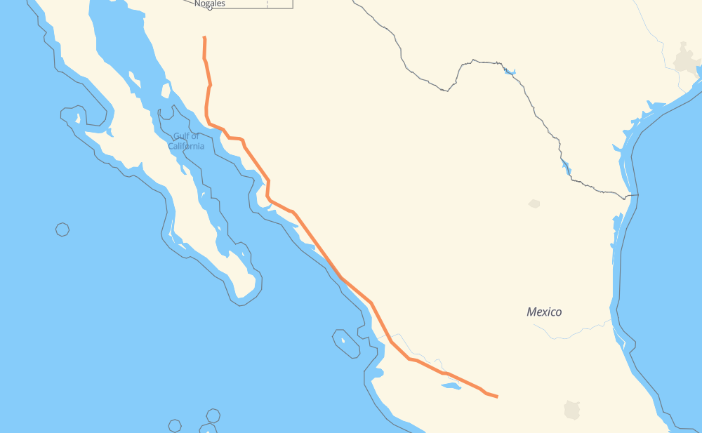
The distance from Huaniqueo de Morales to Catalina Trujillo is 1,086 miles by road including 1,020 miles on motorways. Road takes approximately 18 hours and 53 minutes and goes through Tonalá, Tepic, Dimas (Estación Dimas), Gabriel Leyva Solano, Los Mochis, Navojoa and Hermosillo.
You can adjust fuel consumption and fuel price here.
Toll roads cost:
2,105 + ? MXN
How long is a car ride from Huaniqueo de Morales to Catalina Trujillo?
Driving time:
18 h 53 min
This time is calculated for driving at the maximum permitted speed, taking into account traffic rules restrictions.
260 mi with a maximum speed 68 mph = 3 h 49 min
390 mi with a maximum speed 62 mph = 6 h 16 min
12 mi with a maximum speed 56 mph = 13 min
40 mi with a maximum speed 56 mph = 42 min
361 mi with a maximum speed 50 mph = 7 h 15 min
7 mi with a maximum speed 43 mph = 10 min
12 mi with a maximum speed 37 mph = 18 min
2 mi with a maximum speed 31 mph = 4 min
1 mi with a maximum speed 25 mph = 1 min
The calculated driving time does not take into account intermediate stops and traffic jams.
How far is Huaniqueo de Morales to Catalina Trujillo by land?
The distance between Huaniqueo de Morales and Catalina Trujillo is 1,085.5 mi by road including 1,020.3 mi on motorways.
Precise satellite coordinates of highways were used for this calculation. The start and finish points are the centers of Huaniqueo de Morales and Catalina Trujillo respectively.
How far is Huaniqueo de Morales to Catalina Trujillo by plane?
The shortest distance (air line, as the crow flies) between Huaniqueo de Morales and Catalina Trujillo is 949.5 mi.
This distance is calculated using the Haversine formula as a great-circle distance between two points on the surface of a sphere. The start and finish points are the centers of Huaniqueo de Morales and Catalina Trujillo respectively. Actual distance between airports may be different.
How many hours is Huaniqueo de Morales from Catalina Trujillo by plane?
Boeing 737 airliner needs 1 h 54 min to cover the distance of 949 mi at a cruising speed of 497 mph.
Small plane "Cessna 172" needs 6 h 56 min to flight this distance at average speed of 136 mph.
This time is approximate and do not take into account takeoff and landing times, airport location and other real world factors.
How long is a helicopter ride from Huaniqueo de Morales to Catalina Trujillo?
Fast helicopter "Eurocopter AS350" or "Hughes OH-6 Cayuse" need 6 h 22 min to cover the distance of 949 mi at a cruising speed of 149 mph.
Popular "Robinson R44" needs 7 h 16 min to flight this distance at average speed of 130 mph.
This time is approximate and do not take into account takeoff and landing times, aerodrome location and other real world factors.
What city is halfway between Huaniqueo de Morales and Catalina Trujillo?
The halfway point between Huaniqueo de Morales and Catalina Trujillo is Campo Balbuena. It is located about 16 mi from the exact midpoint by road.
The distance from Campo Balbuena to Huaniqueo de Morales is 559 mi and driving will take about 9 h 32 min. The road between Campo Balbuena and Catalina Trujillo has length 527 mi and will take approximately 9 h 20 min.
The other cities located close to halfway point:
El Batallón is in 561 mi from Huaniqueo de Morales and 524 mi from Catalina Trujillo
Abuya y Ceuta Segunda (Ejido Echeverría) is in 516 mi from Huaniqueo de Morales and 570 mi from Catalina Trujillo
San Blas is in 572 mi from Huaniqueo de Morales and 513 mi from Catalina Trujillo
Where is Huaniqueo de Morales in relation to Catalina Trujillo?
Huaniqueo de Morales is located 949 mi south-east of Catalina Trujillo.
Huaniqueo de Morales has geographic coordinates: latitude 19.89792, longitude -101.50611.
Catalina Trujillo has geographic coordinates: latitude 30.553, longitude -111.12117.
Which highway goes from Huaniqueo de Morales to Catalina Trujillo?
The route from Huaniqueo de Morales to Catalina Trujillo follows MEX 15D.