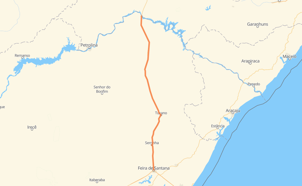
Distance between Ibó and Feira de Santana
The distance from Ibó to Feira de Santana is 267 miles by road. Road takes approximately 5 hours and 6 minutes and goes through Teofilândia, Antônio Conselheiro, Umbuzeiro, Caraíbas and São Cristovão.
| Shortest distance by air | 252 mi ✈️ |
| Car route length | 266.6 mi 🚗 |
| Driving time | 5 h 6 min |
| Fuel amount | 9.1 gal |
| Fuel cost | 35.4 USD |
| Point | Distance | Time | Fuel | |
| -8.62971, -39.24890 | 0 mi | 00 min | 0.0 gal | |
|
BR-116 4 mi, 04 min
|
||||
| Antônio Conselheiro | 4 mi | 04 min | 0.1 gal | |
|
BR-116 9 mi, 10 min
|
||||
| Mocó Gordo | 12 mi | 14 min | 0.3 gal | |
|
BR-116 7 mi, 08 min
|
||||
| Castaninha | 19 mi | 23 min | 0.6 gal | |
|
BR-116 32 mi, 35 min
|
||||
| Caraíbas | 52 mi | 58 min | 1.6 gal | |
|
BR-116 21 mi, 23 min
|
||||
| Serra das Plantas | 72 mi | 1 h 21 min | 2.4 gal | |
|
BR-116 69 mi, 1 h 14 min
|
||||
| Queimada do Raso | 142 mi | 2 h 36 min | 4.7 gal | |
|
BR-116 37 mi, 43 min
|
||||
| Jorrinho | 178 mi | 3 h 20 min | 6.1 gal | |
|
BR-116 9 mi, 10 min
|
||||
| Agrovila Associação Santa Virgínia | 187 mi | 3 h 31 min | 6.2 gal | |
|
BR-116 24 mi, 27 min
|
||||
| Teofilândia | 212 mi | 3 h 58 min | 7.1 gal | |
|
BR-116 46 mi, 50 min
|
||||
| São Cristovão | 257 mi | 4 h 48 min | 8.6 gal | |
|
BR-116 12 mi, 17 min
|
||||
| -12.25789, -38.95980 | 270 mi | 5 h 05 min | 9.2 gal | |
Hotels of Feira de Santana
Frequently Asked Questions
How much does it cost to drive from Ibó to Feira de Santana?
Fuel cost: 35.4 USD
This fuel cost is calculated as: (Route length 266.6 mi) / (Fuel consumption 29.4 mpg) * (Fuel price 3.9 USD / gal)
You can adjust fuel consumption and fuel price here.
How long is a car ride from Ibó to Feira de Santana?
Driving time: 5 h 6 min
This time is calculated for driving at the maximum permitted speed, taking into account traffic rules restrictions.
- 162 mi with a maximum speed 56 mph = 2 h 53 min
- 102 mi with a maximum speed 50 mph = 2 h 3 min
- 6 mi with a maximum speed 37 mph = 8 min
The calculated driving time does not take into account intermediate stops and traffic jams.
How far is Ibó to Feira de Santana by land?
The distance between Ibó and Feira de Santana is 266.6 mi by road.
Precise satellite coordinates of highways were used for this calculation. The start and finish points are the centers of Ibó and Feira de Santana respectively.
How far is Ibó to Feira de Santana by plane?
The shortest distance (air line, as the crow flies) between Ibó and Feira de Santana is 251.7 mi.
This distance is calculated using the Haversine formula as a great-circle distance between two points on the surface of a sphere. The start and finish points are the centers of Ibó and Feira de Santana respectively. Actual distance between airports may be different.
How many hours is Ibó from Feira de Santana by plane?
Boeing 737 airliner needs 30 min to cover the distance of 252 mi at a cruising speed of 497 mph.
Small plane "Cessna 172" needs 1 h 50 min to flight this distance at average speed of 136 mph.
This time is approximate and do not take into account takeoff and landing times, airport location and other real world factors.
How long is a helicopter ride from Ibó to Feira de Santana?
Fast helicopter "Eurocopter AS350" or "Hughes OH-6 Cayuse" need 1 h 41 min to cover the distance of 252 mi at a cruising speed of 149 mph.
Popular "Robinson R44" needs 1 h 55 min to flight this distance at average speed of 130 mph.
This time is approximate and do not take into account takeoff and landing times, aerodrome location and other real world factors.
What city is halfway between Ibó and Feira de Santana?
The halfway point between Ibó and Feira de Santana is Queimada do Raso. It is located about 8 mi from the exact midpoint by road.
The distance from Queimada do Raso to Ibó is 142 mi and driving will take about 2 h 36 min. The road between Queimada do Raso and Feira de Santana has length 125 mi and will take approximately 2 h 29 min.
Where is Ibó in relation to Feira de Santana?
Ibó is located 252 mi north of Feira de Santana.
Ibó has geographic coordinates: latitude -8.62971, longitude -39.2489.
Feira de Santana has geographic coordinates: latitude -12.25789, longitude -38.9598.
Which highway goes from Ibó to Feira de Santana?
The route from Ibó to Feira de Santana follows BR-116.