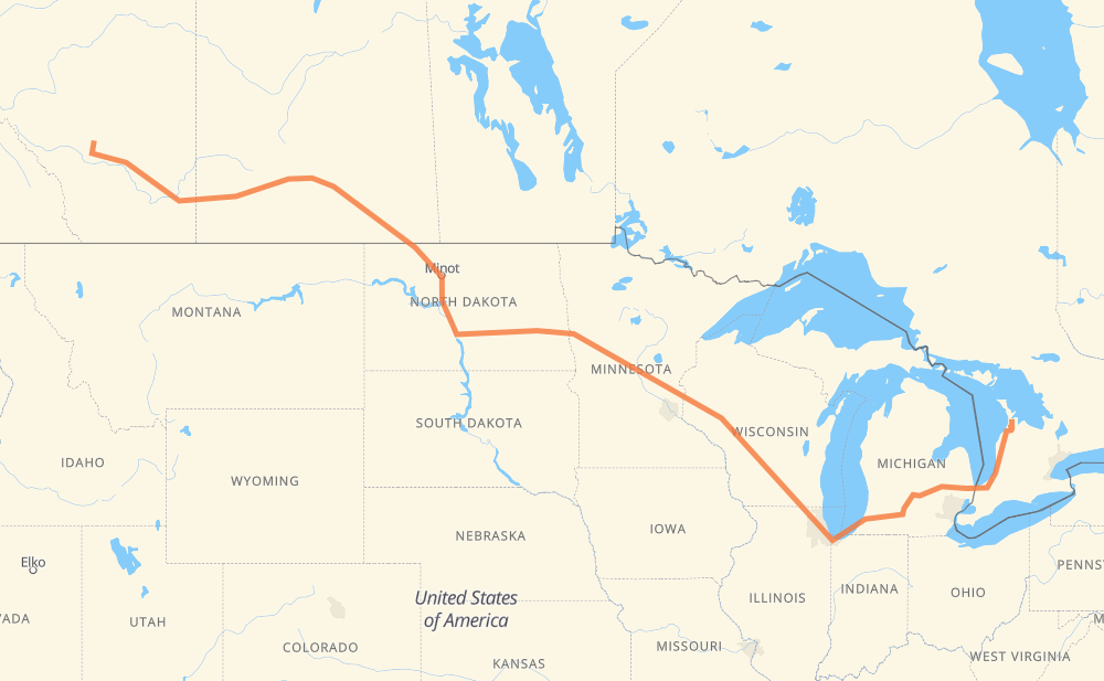
Distance between Irricana AB and Wiarton ON
The distance from Irricana to Wiarton is 2,139 miles by road including 1,212 miles on motorways. Road takes approximately 35 hours and 45 minutes and goes through Chestermere, Brooks, Medicine Hat, Swift Current, Moose Jaw, Weyburn and Estevan.
| Shortest distance by air | 1,553 mi ✈️ |
| Car route length | 2,138.8 mi 🚗 |
| Driving time | 35 h 45 min |
| Fuel amount | 72.7 gal |
| Fuel cost | 285.9 USD |
| Point | Distance | Time | Fuel | |
| Irricana | 0 mi | 00 min | 0.0 gal | |
|
9 24 mi, 26 min
|
||||
| Chestermere | 24 mi | 26 min | 0.8 gal | |
|
1 96 mi, 1 h 42 min
|
||||
| Brooks | 119 mi | 2 h 09 min | 3.9 gal | |
|
1 66 mi, 1 h 10 min
|
||||
| Medicine Hat | 185 mi | 3 h 19 min | 6.2 gal | |
|
1 137 mi, 2 h 27 min
|
||||
| Swift Current | 323 mi | 5 h 47 min | 10.9 gal | |
|
1 102 mi, 1 h 49 min
|
||||
| Moose Jaw | 425 mi | 7 h 37 min | 14.2 gal | |
|
1 39 94 mi, 1 h 44 min
|
||||
| Weyburn | 519 mi | 9 h 21 min | 16.3 gal | |
|
39 54 mi, 1 h 01 min
|
||||
| Estevan | 573 mi | 10 h 22 min | 19.4 gal | |
|
39A US 52 130 mi, 2 h 31 min
|
||||
| Minot | 703 mi | 12 h 53 min | 23.5 gal | |
|
US 83 98 mi, 1 h 54 min
|
||||
| Bismarck | 802 mi | 14 h 48 min | 27.1 gal | |
|
US 83 I 94 181 mi, 2 h 40 min
|
||||
| West Fargo | 984 mi | 17 h 29 min | 33.4 gal | |
|
I 94 5 mi, 04 min
|
||||
| Fargo | 988 mi | 17 h 34 min | 33.5 gal | |
|
US 52 I 94 324 mi, 5 h 00 min
|
||||
| Eau Claire | 1,312 mi | 22 h 34 min | 44.4 gal | |
|
I 94 175 mi, 2 h 35 min
|
||||
| Madison | 1,487 mi | 25 h 10 min | 50.4 gal | |
|
I 39 35 mi, 30 min
|
||||
| Janesville | 1,522 mi | 25 h 40 min | 51.7 gal | |
|
I 39 I 90 107 mi, 1 h 39 min
|
||||
| Chicago | 1,630 mi | 27 h 20 min | 54.9 gal | |
|
I 90 I 94 144 mi, 2 h 12 min
|
||||
| Kalamazoo | 1,773 mi | 29 h 33 min | 60.3 gal | |
|
I 94 I 69 65 mi, 56 min
|
||||
| Lansing | 1,838 mi | 30 h 30 min | 62.5 gal | |
|
I 69 62 mi, 54 min
|
||||
| Flint | 1,900 mi | 31 h 24 min | 64.5 gal | |
|
I 69 76 mi, 1 h 14 min
|
||||
| Sarnia | 1,975 mi | 32 h 39 min | 67.0 gal | |
|
402 21 163 mi, 3 h 05 min
|
||||
| Wiarton | 2,139 mi | 35 h 45 min | 72.6 gal | |
Frequently Asked Questions
How much does it cost to drive from Irricana to Wiarton?
Fuel cost: 285.9 USD
This fuel cost is calculated as: (Route length 2,138.8 mi) / (Fuel consumption 29.4 mpg) * (Fuel price 3.93 USD / gal)
You can adjust fuel consumption and fuel price here.
How long is a car ride from Irricana to Wiarton?
Driving time: 35 h 45 min
This time is calculated for driving at the maximum permitted speed, taking into account traffic rules restrictions.
- 963 mi with a maximum speed 68 mph = 14 h 8 min
- 21 mi with a maximum speed 65 mph = 19 min
- 137 mi with a maximum speed 62 mph = 2 h 12 min
- 21 mi with a maximum speed 60 mph = 20 min
- 634 mi with a maximum speed 56 mph = 11 h 19 min
- 24 mi with a maximum speed 55 mph = 26 min
- 320 mi with a maximum speed 50 mph = 6 h 26 min
- 8 mi with a maximum speed 45 mph = 10 min
- 1 mi with a maximum speed 43 mph = 1 min
- 2 mi with a maximum speed 37 mph = 3 min
- 1 mi with a maximum speed 35 mph = 1 min
- 6 mi with a maximum speed 31 mph = 10 min
- 1 mi with a maximum speed 25 mph = 2 min
The calculated driving time does not take into account intermediate stops and traffic jams.
How far is Irricana to Wiarton by land?
The distance between Irricana and Wiarton is 2,138.8 mi by road including 1,212.3 mi on motorways.
Precise satellite coordinates of highways were used for this calculation. The start and finish points are the centers of Irricana and Wiarton respectively.
How far is Irricana to Wiarton by plane?
The shortest distance (air line, as the crow flies) between Irricana and Wiarton is 1,553.4 mi.
This distance is calculated using the Haversine formula as a great-circle distance between two points on the surface of a sphere. The start and finish points are the centers of Irricana and Wiarton respectively. Actual distance between airports may be different.
How many hours is Irricana from Wiarton by plane?
Boeing 737 airliner needs 3 h 7 min to cover the distance of 1,553 mi at a cruising speed of 497 mph.
Small plane "Cessna 172" needs 11 h 21 min to flight this distance at average speed of 136 mph.
This time is approximate and do not take into account takeoff and landing times, airport location and other real world factors.
How long is a helicopter ride from Irricana to Wiarton?
Fast helicopter "Eurocopter AS350" or "Hughes OH-6 Cayuse" need 10 h 25 min to cover the distance of 1,553 mi at a cruising speed of 149 mph.
Popular "Robinson R44" needs 11 h 54 min to flight this distance at average speed of 130 mph.
This time is approximate and do not take into account takeoff and landing times, aerodrome location and other real world factors.
What city is halfway between Irricana and Wiarton?
The halfway point between Irricana and Wiarton is Fergus Falls. It is located about 24 mi from the exact midpoint by road.
The distance from Fergus Falls to Irricana is 1,046 mi and driving will take about 18 h 30 min. The road between Fergus Falls and Wiarton has length 1,093 mi and will take approximately 17 h 15 min.
The other cities located close to halfway point:
Where is Irricana in relation to Wiarton?
Irricana is located 1,553 mi west of Wiarton.
Irricana has geographic coordinates: latitude 51.32, longitude -113.60319.
Wiarton has geographic coordinates: latitude 44.74074, longitude -81.13324.
Which highway goes from Irricana to Wiarton?
The route from Irricana to Wiarton follows I 94, 1, I 90, US 52, I 69, 39, US 83, I 39, 21.
Other minor sections pass along the road:
- CR 1: 42 mi
- ND 5: 29 mi
- I 694: 29 mi
- 9: 22 mi
- 402: 21 mi
- US 51: 20 mi
- 19: 16 mi
- US 2: 12 mi
- US 59: 11 mi
- 41: 10 mi
- CR 3: 9 mi
- 6: 9 mi
- CR 17: 9 mi
- ND 3: 7 mi
- 39A: 7 mi
- 18: 7 mi
- CR 10: 6 mi
- ND 1: 5 mi
- I 96: 4 mi
- US 10: 4 mi
- ND 200: 4 mi
- MN 95: 4 mi
- US 12: 4 mi
- ND 1804: 4 mi
- 25: 4 mi
- MN 210: 3 mi
- US 31: 3 mi
- US 83 Bypass: 2 mi
- WI 35: 2 mi
- US 52 Truck: 2 mi
- WI 11: 2 mi
- US 281 Truck: 1 mi